
Moores Mill is an unincorporated community and census-designated place (CDP) in Madison County, Alabama, United States, and is included in the Huntsville-Decatur Combined Statistical Area. The population was 6,729 at the 2020 census, up from 5,682 at the 2010 census.

Oroville East or Kelly Ridge is a census-designated place (CDP) in Butte County, California, United States. The population was 8,280 at the 2010 census, down from 8,680 at the 2000 census. Most citizens are dependent on the commerce of Oroville, and the vast majority of high school students in Kelly Ridge attend Las Plumas High School. The community of Kelly Ridge sits at Lake Oroville and offers direct access to boating, camping, fishing and a variety of water sports. Some of Oroville's most beautiful and modern properties can be found here and this neighborhood is also a popular place to retire and enjoy the outdoors.

El Cerrito is a census-designated place (CDP) in Riverside County, California, United States. It is an unincorporated area mostly surrounded by the city of Corona. The population was 5,100 at the 2010 census, up from 4,590 at the 2000 census.

Wilmington Manor is a census-designated place (CDP) in north-eastern New Castle County, Delaware, United States. The population was 7,889 at the 2010 census.

Lake of the Woods is a census-designated place (CDP) in Champaign County, Illinois, United States. The population was 2403 at the 2020 census. Lake of the Woods is in Mahomet Township and mostly surrounded by the northeast part of the village of Mahomet.

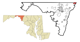
Discovery-Spring Garden is a former census-designated place in Frederick County, Maryland, United States. It is the combination of the two unincorporated communities of Discovery and Spring Garden. As of the 2000 census, the population was 2,152; its population was not counted in 2010.
Chewsville is a census-designated place (CDP) in Washington County, Maryland, United States. The population was 293 at the 2000 census.
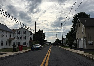
Highfield-Cascade is a census-designated place (CDP) in Washington County, Maryland, United States. The CDP is, however, more commonly referred to as just Cascade, MD. The official CDP name encompasses two closely-spaced unincorporated communities, Highfield and Cascade. The population of the CDP was 1,141 at the 2000 census.

Maugansville is a census-designated place (CDP) in Washington County, Maryland, United States. The population was 2,295 at the 2000 census.

Gray Summit is an unincorporated community and census-designated place (CDP) in Franklin County, Missouri, United States. The population was 2,701 at the 2010 census. Also called "Gray's Summit", it was founded by Daniel Gray of New York, who built a hotel here in 1845. It is located on Missouri Route 100 just north of Interstate 44.

Masonboro was a census-designated place (CDP) in New Hanover County, North Carolina. The last census count in 2000 was 11,812. Masonboro was located southeast of Wilmington near the Atlantic coast.

Sea Breeze is a census-designated place (CDP) in New Hanover County, North Carolina, United States. The population was 1,969 at the 2010 census, up from 1,312 in 2000. It is part of the Wilmington Metropolitan Statistical Area.
Lower Allen is a census-designated place (CDP) in Lower Allen Township in Cumberland County, Pennsylvania, United States. The population was 6,694 at the 2010 census. It is part of the Harrisburg–Carlisle metropolitan statistical area.
Schlusser is a census-designated place (CDP) in North Middleton and Middlesex townships, Cumberland County, Pennsylvania, United States. The population was 5,265 at the 2010 census. It is part of the Harrisburg–Carlisle Metropolitan Statistical Area.

Newington is a census-designated place (CDP) in Fairfax County, Virginia, United States. The population was 12,943 at the 2010 census. The 2010 census showed a significant decrease after half the population was split off to the newly created Newington Forest CDP.
Spotsylvania Courthouse is a census-designated place (CDP) and the county seat of Spotsylvania County, Virginia, United States, located 10 miles (16 km) southwest of Fredericksburg. Recognized by the U.S. Census Bureau as a census designated place (CDP), the population was 4,239 at the 2010 census.

Tichigan is a census-designated place (CDP) in Racine County, Wisconsin, United States. The population was 5,277 at the 2020 census.
Brighton is a census-designated place (CDP) in Monroe County, New York, United States. The population was 36,609 at the 2010 census. The CDP takes its name from locations in the county.
Bennington is a census-designated place (CDP) in Bennington County, Vermont, United States. It is located entirely within the town of Bennington. The population of the CDP was 9,074 at the 2010 census, or 57.6% of the population of the entire town.
Lincoln is a census-designated place (CDP) consisting of the primary settlement in the town of Lincoln in Penobscot County, Maine, United States. The population was 2,884 at the 2010 census.

