
Brunswick County is the southernmost county in the U.S. state of North Carolina. As of the 2020 census, the population was 136,693. Its population was only 73,143 in 2000, making it one of the fastest-growing counties in the state. With a nominal growth rate of approximately 47% in ten years, much of the growth is centered in the eastern section of the county in the suburbs of Wilmington such as Leland, Belville and Southport. The county seat is Bolivia, which at a population of around 150 people is among the least populous county seats in the state.
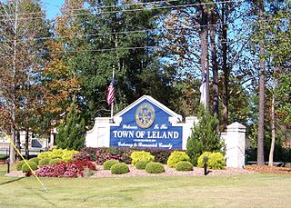
Leland is the most populous town in Brunswick County, North Carolina, United States. The population was 23,504 at the 2020 census, up from 13,527 in 2010. As of 2020, it is considered to be one of the fastest growing towns in North Carolina. It is part of the Myrtle Beach Metropolitan Statistical Area. and the Cape Fear Council of Governments. The town of Leland is in the northeastern part of Brunswick County, with the town of Navassa to the north, Belville to east, and Boiling Springs Lake to the south. It is part of the Town Creek township, and Cape Fear region of North Carolina, a short distance north of the South Carolina state line. Leland is located five miles (8.0 km) west of Wilmington, 71 miles (114 km) north of Myrtle Beach, 84 miles (135 km) southeast of Fayetteville, and 135 miles (217 km) southeast of Raleigh.

Carolina Beach is a beach town in New Hanover County, North Carolina, United States, situated about 12 miles (19 km) south of Wilmington International Airport in southeastern coastal North Carolina. As of the 2020 census, the city population was 6,564. It is part of the Wilmington metropolitan area. The community of Wilmington Beach was annexed by the town in 2000.

Castle Hayne is a census-designated place (CDP) in New Hanover County, North Carolina, United States. The population was 1,202 at the 2010 census, up from 1,116 in 2000. It is part of the Wilmington Metropolitan Statistical Area.

Kure Beach is a town in New Hanover County, North Carolina, United States, approximately 15 miles south of Wilmington. It is part of the Wilmington Metropolitan Statistical Area. The population was 2,012 at the 2010 census. It is found on Pleasure Island directly south of the Wilmington Beach annex of Carolina Beach and just north of Fort Fisher. The town is less than 1 square mile (2.6 km2) in area, stretching along about 3.5 miles (5.6 km) of coastline along Pleasure Island, and a maximum width of less than 0.5 miles (0.80 km), in most places only a few hundred yard/meters wide.

Masonboro was a census-designated place (CDP) in New Hanover County, North Carolina. The last census count in 2000 was 11,812. Masonboro was located southeast of Wilmington near the Atlantic coast.

Sea Breeze is a census-designated place (CDP) in New Hanover County, North Carolina, United States. The population was 1,969 at the 2010 census, up from 1,312 in 2000. It is part of the Wilmington Metropolitan Statistical Area.
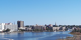
Wilmington is a port city in and the county seat of New Hanover County in coastal southeastern North Carolina. With a population of 115,451 at the 2020 census, it is the eighth-most populous city in the state. Wilmington is the principal city of the Wilmington Metropolitan Statistical Area, which includes New Hanover and Pender counties in southeastern North Carolina, which had a population of 285,905 in 2020.

Wrightsville Beach is a town in New Hanover County, North Carolina, United States. Wrightsville Beach is just east of Wilmington and is part of the Wilmington Metropolitan Statistical Area. The population was 2,477 at the 2010 census. The town consists of a 4-mile (6 km) long beach island, an interior island called Harbor Island, and pockets of commercial property on the mainland. It served as a filming location of Dawson's Creek.

Port Royal is a town on Port Royal Island in Beaufort County, South Carolina, United States. The population was 14,220 at the 2020 census. It is part of the Hilton Head Island–Bluffton metropolitan area. Port Royal is home to Marine Corps Recruit Depot Parris Island and United States Naval Hospital Beaufort.

Beach City is a U.S. city in Chambers County, Texas. The population was 3,221 at the 2020 census. It can now be considered as a part of Greater Houston.

Hebron is a town in Denton County in the U.S. state of Texas with a small disconnected section in Collin County. The population was 415 at the 2010 census.

Surf City is a town in Pender and Onslow counties in the U.S. state of North Carolina. The population was 1,853 at the 2010 census. It is located on Topsail Island.

Cape Fear is a coastal plain and Tidewater region of North Carolina centered about the city of Wilmington. The region takes its name from the adjacent Cape Fear headland, as does the Cape Fear River which flows through the region and empties into the Atlantic Ocean near the cape. Much of the region's populated areas are found along the Atlantic beaches and the Atlantic Intracoastal Waterway, while the rural areas are dominated by farms and swampland like that of the Green Swamp. The general area can be also identified by the titles "Lower Cape Fear", "Wilmington Metropolitan Area", "Southeastern North Carolina", and "Azalea Coast". The latter name is derived from the North Carolina Azalea Festival held annually in Wilmington. Municipalities in the area belong to the Cape Fear Council of Governments.

Pleasure Island is a coastal barrier island in Southeastern North Carolina, United States, just south of the City of Wilmington. Pleasure Island is located within Federal Point Township, in New Hanover County. The coastal resort towns of Carolina Beach and Kure Beach, as well as the annexed communities of Wilmington Beach and Hanby Beach are located on the island. The southern end of Pleasure Island was separated from Bald Head Island by Corncake Inlet until the inlet was shoaled and closed in 1998 by Hurricane Bonnie; thus Pleasure Island and Bald Head Island are no longer separate islands.

Monkey Junction is an unincorporated area near Wilmington in New Hanover County at the intersection of College Road and Carolina Beach Road. It is one of several centers of recent commercial and residential growth near Wilmington. In 2008, Wilmington began controversial efforts to annex the community, but in 2012, the annexation requests were overturned by the North Carolina General Assembly.

East Toronto was an incorporated community, currently part of Toronto, Ontario, Canada. It covered much of the present day neighbourhood of the Upper Beaches, stretching up to Danforth Avenue in the north, part of it stretching to Lake Ontario in the south a portion of the present-day neighbourhood, The Beaches. The central street in East Toronto was Main Street, running between Danforth Avenue to Kingston Road. The commercial centre of the town was located at the intersection of Main Street and Lake View Avenue. Following the annexation of East Toronto into Toronto, Main Street retained its name despite Toronto's conceptual Main Street being historically designated to be Yonge Street.

U.S. Route 421 (US 421) is part of the United States Numbered Highway System that runs from Fort Fisher, North Carolina to Michigan City, Indiana. In the U.S. state of North Carolina, US 421 travels 328 miles (528 km) from its southern terminus at Fort Fisher to the Tennessee state line near the community of Zionville, North Carolina. US 421 traverses the state from east to west travelling from the coastal plains to Appalachian Mountains. It provides an important connection between the cities of Wilmington, Sanford, Greensboro, Winston-Salem, and Boone. Despite being signed as north–south, much of the routing of US 421 in North Carolina runs in an east–west direction, particularly between Greensboro and the Tennessee state line. Portions of US 421 have been upgraded to freeway standards including the majority of its routing between Sanford and North Wilkesboro.
Rocky Point is a census-designated place and unincorporated community in southern Pender County, North Carolina, United States. It is part of the Wilmington Metropolitan Statistical Area. Rocky Point is situated on North Carolina Highway 210, North Carolina Highway 133 and U.S. Route 117, at an elevation of 39 feet. The ZIP Code for Rocky Point is 28457.

