Laurel Park, Virginia

Last updated

Laurel Park, Virginia
CDP
VAMap-doton-LaurelPark.PNG
Location of Laurel Park, Virginia
Coordinates: 36°41′23″N79°47′27″W / 36.68972°N 79.79083°W / 36.68972; -79.79083
CountryUnited States
State Virginia
County Henry
Area
  Total1.3 sq mi (3.3 km2)
  Land1.3 sq mi (3.3 km2)
  Water0.0 sq mi (0.0 km2)
Elevation
791 ft (241 m)
Population
 (2010)
  Total675
  Density520/sq mi (200/km2)
Time zone UTC−5 (Eastern (EST))
  Summer (DST) UTC−4 (EDT)
FIPS code 51-44476 [1]
GNIS feature ID1497321 [2]

Laurel Park is a census-designated place (CDP) in Henry County, Virginia, United States. The population was 675 at the 2010 census. It is part of the Martinsville Micropolitan Statistical Area.

Contents

Geography

Laurel Park is located at 36°41′23″N79°47′27″W / 36.68972°N 79.79083°W / 36.68972; -79.79083 (36.689798, 79.790791). [3]

According to the United States Census Bureau, the CDP has a total area of 1.3 square miles (3.3 km2), of which, 1.3 square miles (3.3 km2) of it is land and 0.78% is water. Laurel Park is not to be confused with the housing estate within the Laurel region of Henrico County, Virginia. Also, Henry County is not to be confused with Henrico County, also in Virginia. Henrico is a largely suburban county surrounding Richmond north of the James River.

Demographics

2020 census

Laurel Park CDP, Virginia – Racial and ethnic composition
Note: the US Census treats Hispanic/Latino as an ethnic category. This table excludes Latinos from the racial categories and assigns them to a separate category. Hispanics/Latinos may be of any race.
Race / Ethnicity (NH = Non-Hispanic)Pop 2010 [4] Pop 2020 [5] % 2010% 2020
White alone (NH)22217032.89%25.88%
Black or African American alone (NH)41442361.33%64.38%
Native American or Alaska Native alone (NH)000.00%0.00%
Asian alone (NH)791.04%1.37%
Pacific Islander alone (NH)010.00%0.15%
Some Other Race alone (NH)010.00%0.15%
Mixed Race or Multi-Racial (NH)9171.33%2.59%
Hispanic or Latino (any race)23363.41%5.48%
Total675657100.00%100.00%

2000 census

As of the census [1] of 2000, there were 781 people, 331 households, and 231 families residing in the CDP. The population density was 614.4 people per square mile (237.4/km2). There were 342 housing units at an average density of 269.0/sq mi (104.0/km2). The racial makeup of the CDP was 33.29% White, 64.40% African American, 0.38% Asian, 0.13% Pacific Islander, 1.15% from other races, and 0.64% from two or more races. Hispanic or Latino of any race were 1.92% of the population.

There were 331 households, out of which 34.1% had children under the age of 18 living with them, 52.3% were married couples living together, 15.7% had a female householder with no husband present, and 30.2% were non-families. 27.5% of all households were made up of individuals, and 5.4% had someone living alone who was 65 years of age or older. The average household size was 2.36 and the average family size was 2.87.

In the CDP, the population was spread out, with 24.7% under the age of 18, 9.6% from 18 to 24, 30.1% from 25 to 44, 29.1% from 45 to 64, and 6.5% who were 65 years of age or older. The median age was 36 years. For every 100 females, there were 87.3 males. For every 100 females age 18 and over, there were 80.9 males.

The median income for a household in the CDP was $42,361, and the median income for a family was $47,143. Males had a median income of $29,904 versus $23,363 for females. The per capita income for the CDP was $17,413. About 2.7% of families and 3.8% of the population were below the poverty line, including none of those under the age of eighteen or sixty-five or over.

Related Research Articles

<span class="mw-page-title-main">West Laurel, Maryland</span> Census-designated place in Maryland

West Laurel is an unincorporated area and census-designated place (CDP) in Prince George's County, Maryland, United States. Per the 2020 census, the population was 4,428.

<span class="mw-page-title-main">Laurel, New York</span> Hamlet and census-designated place in New York, United States

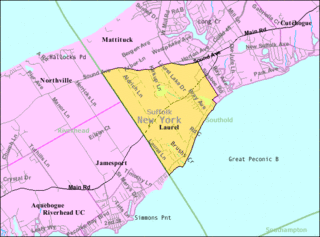
Laurel is a census-designated place (CDP) roughly corresponding to the hamlet of Laurel in Suffolk County, New York, United States. It is located mostly within the Town of Southold, with a small portion in the Town of Riverhead. The population was 1,394 at the 2010 census.

<span class="mw-page-title-main">Greenville, Virginia</span> CDP in Virginia, United States

Greenville is a census-designated place (CDP) in Augusta County, Virginia, United States. The population was 887 at the 2020 census. It is part of the Staunton–Waynesboro Micropolitan Statistical Area.

<span class="mw-page-title-main">Jolivue, Virginia</span> Census-designated place in Virginia, United States

Jolivue is a census-designated place (CDP) in Augusta County, Virginia, United States. The population was 1,129 at the 2010 census. It is part of the Staunton–Waynesboro Micropolitan Statistical Area.

<span class="mw-page-title-main">Verona, Virginia</span> CDP in Virginia, United States

Verona is a census-designated place (CDP) in Augusta County, Virginia, United States. The population was 4,239 at the 2010 census. It is part of the Staunton–Waynesboro Micropolitan Statistical Area.

<span class="mw-page-title-main">Timberlake, Virginia</span> CDP in Virginia, United States

Timberlake is a census-designated place (CDP) in Campbell County, Virginia, United States. The population was 13,267 at the 2020 census. It is part of the Lynchburg Metropolitan Statistical Area.

<span class="mw-page-title-main">Chamberlayne, Virginia</span> Census-designated place in Virginia

Chamberlayne is a census-designated place (CDP) in Henrico County, Virginia, United States. The population was 5,581 at the 2020 census.

<span class="mw-page-title-main">East Highland Park, Virginia</span> Census-designated place in Virginia

East Highland Park is a census-designated place (CDP) in Henrico County, Virginia, in the United States. The population was 15,131 at the 2020 census.

<span class="mw-page-title-main">Highland Springs, Virginia</span> Census-designated place in Virginia

Highland Springs is a census-designated place (CDP) located in Henrico County, Virginia, United States, 4.3 miles (7 km) east of Richmond. The population was 16,604 at the 2020 census.

<span class="mw-page-title-main">Laurel, Virginia</span> Census-designated place in Virginia, United States

Laurel is a census-designated place (CDP) in western Henrico County, Virginia, United States. The population was 17,769 at the 2020 United States Census. It is the county seat of Henrico County.

<span class="mw-page-title-main">Montrose, Virginia</span> Census-designated place in Virginia

Montrose is a census-designated place (CDP) in Henrico County, Virginia, United States. The population was 7,909 at the 2020 census.

<span class="mw-page-title-main">Tuckahoe, Virginia</span> Census-designated place in Virginia

Tuckahoe is a census-designated place (CDP) in Henrico County, Virginia, United States. It is an upper middle-class suburb to the west of Richmond. The population of Tuckahoe was 44,990 at the 2010 census. It is named after the area's history as the site of Thomas Randolph's Tuckahoe Plantation which still stands along the James River.

<span class="mw-page-title-main">Wyndham, Virginia</span> Census-designated place in Virginia

Wyndham is a census-designated place (CDP) in Henrico County, Virginia, United States, in the West End area outside of Richmond. The population was 9,785 at the 2010 census. The CDP is named for Wyndham, a planned community there. It is an affluent suburb of Richmond, Virginia.

<span class="mw-page-title-main">Horsepasture, Virginia</span> CDP in Virginia, United States

Horsepasture is a census-designated place (CDP) in Henry County, Virginia, United States. The population was 2,227 at the 2010 census. It is part of the Martinsville Micropolitan Statistical Area.

<span class="mw-page-title-main">Oak Level, Virginia</span> CDP in Virginia, United States

Oak Level is a census-designated place (CDP) in Henry County, Virginia, United States. The population was 857 at the 2010 census. It is part of the Martinsville Micropolitan Statistical Area.

Sandy Level is a census-designated place (CDP) in Henry County, Virginia, United States. The population was 484 at the 2010 census, which was a significant decrease from the 689 reported in 2000. It is part of the Martinsville Micropolitan Statistical Area.

<span class="mw-page-title-main">Stanleytown, Virginia</span> CDP in Virginia, United States

Stanleytown is a census-designated place (CDP) in Henry County, Virginia, United States. The population was 1,422 at the 2010 census. It is part of the Martinsville Micropolitan Statistical Area.

Villa Heights is a census-designated place (CDP) in Henry County, Virginia, United States. The population was 717 at the 2010 census. It is part of the Martinsville Micropolitan Statistical Area.

<span class="mw-page-title-main">Laurel Hill, Virginia</span> Census-designated place in Virginia, United States

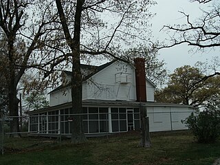
Laurel Hill is a census-designated place in Fairfax County, Virginia, United States. The population at the 2020 census was 8,307. Formerly part of the Lorton CDP, it comprises most of what was formerly the Lorton Reformatory grounds, which were purchased by Fairfax County in 2002 following the prison's closing and redeveloped as a new suburban community. The name "Laurel Hill" was adopted from Laurel Hill House, an 18th-century structure which had served as the residence of the Superintendent of the Reformatory, and originally was the home of Revolutionary War patriot William Lindsay.

Norridgewock is a census-designated place (CDP) in the town of Norridgewock in Somerset County, Maine, United States. The population was 1,351 at the 2020 census.

References

  1. 1 2 "U.S. Census website". United States Census Bureau . Retrieved January 31, 2008.
  2. "US Board on Geographic Names". United States Geological Survey. October 25, 2007. Retrieved January 31, 2008.
  3. "US Gazetteer files: 2010, 2000, and 1990". United States Census Bureau. February 12, 2011. Retrieved April 23, 2011.
  4. "P2 Hispanic or Latino, and Not Hispanic or Latino by Race – 2010: DEC Redistricting Data (PL 94-171) – Laurel Park CDP, Virginia". United States Census Bureau .
  5. "P2 Hispanic or Latino, and Not Hispanic or Latino by Race – 2020: DEC Redistricting Data (PL 94-171) - Laurel Park CDP, Virginia". United States Census Bureau .