Sandy Level, Virginia

Last updated

Sandy Level, Virginia
USA Virginia location map.svg
Red pog.svg
Sandy Level
Usa edcp location map.svg
Red pog.svg
Sandy Level
Coordinates: 36°33′33″N79°43′35″W / 36.55917°N 79.72639°W / 36.55917; -79.72639
CountryUnited States
State Virginia
County Henry
Area
  Total6.8 sq mi (17.6 km2)
  Land6.7 sq mi (17.5 km2)
  Water0.0 sq mi (0.1 km2)
Elevation
794 ft (242 m)
Population
 (2010)
  Total484
  Density71/sq mi (28/km2)
Time zone UTC−5 (Eastern (EST))
  Summer (DST) UTC−4 (EDT)
FIPS code 51-70296 [1]
GNIS feature ID1474026 [2]

Sandy Level is a census-designated place (CDP) in Henry County, Virginia, United States. The population was 484 at the 2010 census, which was a significant decrease from the 689 reported in 2000. It is part of the Martinsville Micropolitan Statistical Area.

Contents

Geography

Sandy Level is located at 36°33′33″N79°43′35″W / 36.55917°N 79.72639°W / 36.55917; -79.72639 (36.559188, 79.726501). [3]

According to the United States Census Bureau, the CDP has a total area of 6.8 square miles (17.6 km2), of which, 6.7 square miles (17.5 km2) of it is land and 0.04 square miles (0.1 km2) of it is water. The total area is 0.59% water.

Demographics

2020 census

Sandy Level CDP, Virginia – Racial and ethnic composition
Note: the US Census treats Hispanic/Latino as an ethnic category. This table excludes Latinos from the racial categories and assigns them to a separate category. Hispanics/Latinos may be of any race.
Race / Ethnicity (NH = Non-Hispanic)Pop 2010 [4] Pop 2020 [5] % 2010% 2020
White alone (NH)17118235.33%39.22%
Black or African American alone (NH)30123462.19%50.43%
Native American or Alaska Native alone (NH)0110.00%2.37%
Asian alone (NH)020.00%0.43%
Pacific Islander alone (NH)000.00%0.00%
Some Other Race alone (NH)010.00%0.22%
Mixed Race or Multi-Racial (NH)8151.65%3.23%
Hispanic or Latino (any race)4190.83%4.09%
Total484464100.00%100.00%

2000 census

As of the census [1] of 2000, there were 689 people, 256 households, and 186 families residing in the CDP. The population density was 102.2 people per square mile (39.5/km2). There were 277 housing units at an average density of 41.1/sq mi (15.9/km2). The racial makeup of the CDP was 25.69% White, 73.29% African American, 0.15% Native American, and 0.87% from two or more races. Hispanic or Latino of any race were 0.58% of the population.

There were 256 households, out of which 30.5% had children under the age of 18 living with them, 43.0% were married couples living together, 24.2% had a female householder with no husband present, and 27.0% were non-families. 24.2% of all households were made up of individuals, and 7.4% had someone living alone who was 65 years of age or older. The average household size was 2.69 and the average family size was 3.22.

In the CDP, the population was spread out, with 28.0% under the age of 18, 8.7% from 18 to 24, 27.0% from 25 to 44, 24.4% from 45 to 64, and 11.9% who were 65 years of age or older. The median age was 34 years. For every 100 females, there were 84.2 males. For every 100 females age 18 and over, there were 83.7 males.

The median income for a household in the CDP was $20,089, and the median income for a family was $37,011. Males had a median income of $27,969 versus $19,342 for females. The per capita income for the CDP was $12,757. About 15.5% of families and 21.4% of the population were below the poverty line, including 22.1% of those under age 18 and 38.1% of those age 65 or over.

Related Research Articles

<span class="mw-page-title-main">West Crossett, Arkansas</span> CDP in Arkansas, United States

West Crossett is a census-designated place (CDP) in Ashley County, Arkansas, United States. Per the 2020 census, the population was 1,144.

<span class="mw-page-title-main">Salem, Saline County, Arkansas</span> CDP in Arkansas, United States

Salem is a census-designated place (CDP) in Saline County, Arkansas, United States. Per the 2020 census, the population was 2,544. It is part of the Little Rock–North Little Rock–Conway Metropolitan Statistical Area.

<span class="mw-page-title-main">Olympia Heights, Florida</span> Census-designated place in Florida

Olympia Heights is a census-designated place in Miami-Dade County, Florida, United States. It is located in the Miami metropolitan area of South Florida. The population was 12,873 at the 2020 census.

<span class="mw-page-title-main">Pinewood, Florida</span> Census-designated place in Florida

Pinewood is an unincorporated community and census-designated place (CDP) in Miami-Dade County, Florida, United States. It is part of the Miami metropolitan area of South Florida. The population was 17,246 at the 2020 census.

<span class="mw-page-title-main">Westview, Florida</span> Census-designated place in Florida

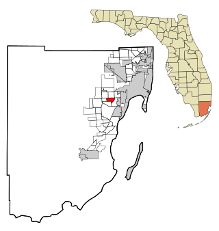
Westview is a census-designated place (CDP) in Miami-Dade County, Florida, United States. It is part of the Miami metropolitan area of South Florida. The population was 9,923 at the 2020 census.

<span class="mw-page-title-main">South Apopka, Florida</span> Census-designated place in Florida, United States

South Apopka is a census-designated place and an unincorporated area in Orange County, Florida, United States. Per the 2020 census, the population was 6,803. It is part of the Orlando–Kissimmee Metropolitan Statistical Area.

Long Lake is an unincorporated community and census-designated place (CDP) in Lake County, Illinois, United States. Per the 2020 census, the population was 3,663.

<span class="mw-page-title-main">Frankfort Square, Illinois</span> Census-designated place in Illinois, United States

Frankfort Square is a census-designated place (CDP) in Will County, Illinois, United States. Per the 2020 census, the population was 8,968.

<span class="mw-page-title-main">Willow Brook Estates, Illinois</span> Census-designated place in Illinois, United States

Willow Brook Estates is an unincorporated census-designated place in Will County, Illinois, United States. The population was 1,346 at the 2020 census. it is considered a far south suburb of Chicago.

Garyville is a census-designated place (CDP) in St. John the Baptist Parish, Louisiana, United States. The population was 2,775 at the 2000 census and 2,123 in 2020. It is part of the New Orleans–Metairie–Kenner Metropolitan Statistical Area.

<span class="mw-page-title-main">Fairland, Maryland</span> Census-designated place in Maryland, United States

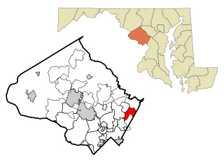
Fairland is a census-designated place and an unincorporated area in Montgomery County, Maryland, United States. It had a population of 25,396 per the 2020 census.

<span class="mw-page-title-main">Benton Heights, Michigan</span> Census-designated place & unincorporated community in Michigan, United States

Benton Heights is an unincorporated community in Berrien County in the U.S. state of Michigan. It is also a census-designated place (CDP) for statistical purposes without any legal status as an incorporated municipality. Per the 2020 Census, the population was 3,652. The community is a part of Benton Charter Township and is adjacent to the city of Benton Harbor.

<span class="mw-page-title-main">Castle Point, Missouri</span> Place in Missouri, United States

Castle Point is an unincorporated community and census-designated place (CDP) in St. Louis County, Missouri, United States. The population was 3,962 at the 2010 census.

<span class="mw-page-title-main">Lakeview, New York</span> Hamlet and Census-designated place in New York, United States

Lakeview is a hamlet and census-designated place (CDP) in the Town of Hempstead in Nassau County, on Long Island, in New York, United States. The population was 6,077 at the 2020 census.

<span class="mw-page-title-main">Fairview, Westchester County, New York</span> CDP in New York, United States

Fairview is a hamlet and a census-designated place (CDP) located in the town of Greenburgh, Westchester County, New York, United States. The population was 3,099 at the 2010 census. As of 2000, Fairview had the fourth-highest percentage of African-Americans in New York.

<span class="mw-page-title-main">Jolivue, Virginia</span> Census-designated place in Virginia, United States

Jolivue is a census-designated place (CDP) in Augusta County, Virginia, United States. The population was 1,129 at the 2010 census. It is part of the Staunton–Waynesboro Micropolitan Statistical Area.

<span class="mw-page-title-main">Verona, Virginia</span> CDP in Virginia, United States

Verona is a census-designated place (CDP) in Augusta County, Virginia, United States. The population was 4,239 at the 2010 census. It is part of the Staunton–Waynesboro Micropolitan Statistical Area.

<span class="mw-page-title-main">East Highland Park, Virginia</span> Census-designated place in Virginia

East Highland Park is a census-designated place (CDP) in Henrico County, Virginia, in the United States. The population was 15,131 at the 2020 census.

<span class="mw-page-title-main">Montrose, Virginia</span> Census-designated place in Virginia

Montrose is a census-designated place (CDP) in Henrico County, Virginia, United States. The population was 7,909 at the 2020 census.

<span class="mw-page-title-main">Laurel Park, Virginia</span> CDP in Virginia, United States

Laurel Park is a census-designated place (CDP) in Henry County, Virginia, United States. The population was 675 at the 2010 census. It is part of the Martinsville Micropolitan Statistical Area.

References

  1. 1 2 "U.S. Census website". United States Census Bureau . Retrieved January 31, 2008.
  2. "US Board on Geographic Names". United States Geological Survey. October 25, 2007. Retrieved January 31, 2008.
  3. "US Gazetteer files: 2010, 2000, and 1990". United States Census Bureau. February 12, 2011. Retrieved April 23, 2011.
  4. "P2 Hispanic or Latino, and Not Hispanic or Latino by Race – 2010: DEC Redistricting Data (PL 94-171) – Sandy Level CDP, Virginia". United States Census Bureau .
  5. "P2 Hispanic or Latino, and Not Hispanic or Latino by Race – 2020: DEC Redistricting Data (PL 94-171) - Sandy Level CDP, Virginia". United States Census Bureau .