Villa Heights, Virginia

Last updated
Villa Heights, Virginia
USA Virginia location map.svg
Red pog.svg
Villa Heights
Usa edcp location map.svg
Red pog.svg
Villa Heights
Coordinates: 36°41′59″N79°53′59″W / 36.69972°N 79.89972°W / 36.69972; -79.89972 Coordinates: 36°41′59″N79°53′59″W / 36.69972°N 79.89972°W / 36.69972; -79.89972
CountryUnited States
State Virginia
County Henry
Area
  Total1.0 sq mi (2.5 km2)
  Land1.0 sq mi (2.5 km2)
  Water0.0 sq mi (0.0 km2)
Elevation
735 ft (224 m)
Population
 (2010)
  Total717
  Density720/sq mi (290/km2)
Time zone UTC−5 (Eastern (EST))
  Summer (DST) UTC−4 (EDT)
FIPS code 51-81152 [1]
GNIS feature ID1867600 [2]

Villa Heights is a census-designated place (CDP) in Henry County, Virginia, United States. The population was 717 at the 2010 census. It is part of the Martinsville Micropolitan Statistical Area.

Contents

Geography

Villa Heights is located at 36°41′59″N79°53′59″W / 36.69972°N 79.89972°W / 36.69972; -79.89972 (36.699667, 79.899666). [3]

According to the United States Census Bureau, the CDP has a total area of 1.0 square miles (2.5 km2), all of it land.

Demographics

As of the census [1] of 2000, there were 845 people, 343 households, and 229 families residing in the CDP. The population density was 877.9 people per square mile (339.9/km2). There were 358 housing units at an average density of 372.0/sq mi (144.0/km2). The racial makeup of the CDP was 73.02% White, 20.71% African American, 4.97% from other races, and 1.30% from two or more races. Hispanic or Latino of any race were 18.34% of the population.

There were 343 households, out of which 26.5% had children under the age of 18 living with them, 45.2% were married couples living together, 16.0% had a female householder with no husband present, and 33.2% were non-families. 28.9% of all households were made up of individuals, and 13.1% had someone living alone who was 65 years of age or older. The average household size was 2.46 and the average family size was 2.98.

In the CDP, the population was spread out, with 21.5% under the age of 18, 11.2% from 18 to 24, 29.0% from 25 to 44, 21.4% from 45 to 64, and 16.8% who were 65 years of age or older. The median age was 36 years. For every 100 females, there were 95.6 males. For every 100 females age 18 and over, there were 95.0 males.

The median income for a household in the CDP was $25,526, and the median income for a family was $30,052. Males had a median income of $21,488 versus $17,300 for females. The per capita income for the CDP was $13,491. About 10.2% of families and 18.6% of the population were below the poverty line, including 19.9% of those under age 18 and none of those age 65 or over.

Related Research Articles

Wofford Heights, California census-designated place in California, United States

Wofford Heights is a census-designated place (CDP) in the southern Sierra Nevada, in Kern County, California, United States. Wofford Heights is located in the west Kern River Valley, 3.5 miles (5.6 km) south-southwest of Kernville, at an elevation of 2,684 feet (818 m). The population was 2,200 at the 2010 census, down from 2,276 at the 2000 census.

Holden Heights, Florida Census-designated place in Florida, United States

Holden Heights is a census-designated place and unincorporated area in Orange County, Florida, United States. The population was 3,679 at the 2010 census. The ZIP code serving the CDP is 32839. It is part of the Orlando–Kissimmee Metropolitan Statistical Area.

Benton Heights, Michigan Census-designated place & unincorporated community in Michigan, United States

Benton Heights is an unincorporated community in Berrien County in the U.S. state of Michigan. It is also a census-designated place (CDP) for statistical purposes without any legal status as an incorporated municipality. The population was 4,084 at the 2010 Census, down from 5,458 at the 2000 census. The community is a part of Benton Charter Township and is adjacent to the city of Benton Harbor.

Pemberton Heights, New Jersey Census-designated place in New Jersey, United States

Pemberton Heights is an unincorporated community and census-designated place (CDP) located within Pemberton Township, in Burlington County, New Jersey, United States. As of the 2010 United States Census, the CDP's population was 2,423.

Washington Heights, New York CDP in New York, United States

Washington Heights is a census-designated place (CDP) in Orange County, New York, United States. The population was 1,689 at the 2010 census.

Ashley Heights, North Carolina Census-designated place in North Carolina, United States

Ashley Heights is an unincorporated community and census-designated place (CDP) in Hoke County, North Carolina, United States. The population was 380 at the 2010 census.

Lenape Heights, Pennsylvania Census-designated place in Pennsylvania, United States

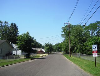
Lenape Heights is a census-designated place (CDP) in Armstrong County, Pennsylvania, United States. The population was 1,167 at the 2010 census.

Orchard Hills, Pennsylvania Census-designated place in Pennsylvania, United States

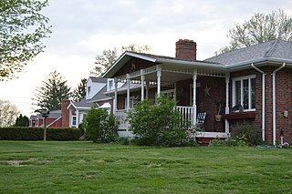
Orchard Hills is a census-designated place (CDP) in Armstrong County, Pennsylvania, United States. The population was 1,952 at the 2010 census.

Shanor-Northvue, Pennsylvania Census-designated place in Pennsylvania, United States

Shanor-Northvue is a census-designated place (CDP) in Butler County, Pennsylvania, United States. The population was 5,051 at the 2010 census.

Elim, Pennsylvania Census-designated place in Pennsylvania, United States

Elim is an unincorporated community and census-designated place (CDP) in Upper Yoder Township, Cambria County, Pennsylvania, United States. The population was 3,727 at the 2010 census, down from 4,175 at the 2000 census.

Chevy Chase Heights, Pennsylvania Census-designated place in Pennsylvania, United States

Chevy Chase Heights is a census-designated place within White Township, Indiana County, Pennsylvania, United States. The population was 1,502 at the 2010 census.

Hasson Heights is a census-designated place (CDP) in Venango County, Pennsylvania, United States. The population was 1,351 at the 2010 census.

Woodland Heights, Pennsylvania CDP in Pennsylvania, United States

Woodland Heights is a census-designated place (CDP) in Venango County, Pennsylvania, United States. The population was 1,402 at the 2000 census.

Grapeville, Pennsylvania CDP in Pennsylvania, United States

Grapeville is a census-designated place (CDP) in Hempfield Township, Westmoreland County, Pennsylvania, United States. The population was 676 at the 2000 census.

Lawson Heights, Pennsylvania CDP in Pennsylvania, United States

Lawson Heights is a census-designated place (CDP) in Unity Township, Westmoreland County, Pennsylvania, United States. The population was 2,339 at the 2000 census.

South Huntingdon Township, Westmoreland County, Pennsylvania Township in Pennsylvania, United States

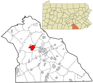
South Huntingdon Township is a township in Westmoreland County, Pennsylvania, United States. The population was 6,175 at the 2000 census.

Weigelstown, Pennsylvania CDP in Pennsylvania, United States

Weigelstown is a census-designated place (CDP) in York County, Pennsylvania, United States. The population was 12,875 at the 2010 census.

Colonial Heights is a census-designated place (CDP) in Sullivan County, Tennessee, United States. The population was 6,934 at the 2010 census. It is part of the Kingsport–Bristol (TN)–Bristol (VA) Metropolitan Statistical Area, which is a component of the Johnson City–Kingsport–Bristol, TN-VA Combined Statistical Area – commonly known as the "Tri-Cities" region.

Timberlake, Virginia CDP in Virginia, United States

Timberlake is a census-designated place (CDP) in Campbell County, Virginia, United States. The population was 12,183 at the 2010 census. It is part of the Lynchburg Metropolitan Statistical Area.

Fieldale, Virginia CDP in Virginia, United States

Fieldale is a census-designated place (CDP) in Henry County, Virginia, United States. The population was 879 at the 2010 census. It is part of the Martinsville Micropolitan Statistical Area.

References

  1. 1 2 "U.S. Census website". United States Census Bureau . Retrieved 2008-01-31.
  2. "US Board on Geographic Names". United States Geological Survey. 2007-10-25. Retrieved 2008-01-31.
  3. "US Gazetteer files: 2010, 2000, and 1990". United States Census Bureau. 2011-02-12. Retrieved 2011-04-23.