Oak Level, Virginia

Last updated

Oak Level, Virginia
CDP
VAMap-doton-Oaklevel.PNG
Location of Oak Level, Virginia
Coordinates: 36°47′51″N79°56′22″W / 36.79750°N 79.93944°W / 36.79750; -79.93944
CountryUnited States
State Virginia
County Henry
Area
  Total6.1 sq mi (15.8 km2)
  Land6.1 sq mi (15.8 km2)
  Water0.0 sq mi (0.0 km2)
Elevation
1,280 ft (390 m)
Population
 (2010)
  Total857
  Density140/sq mi (54/km2)
Time zone UTC−5 (Eastern (EST))
  Summer (DST) UTC−4 (EDT)
ZIP code
24055
Area code 276
FIPS code 51-58312 [1]
GNIS feature ID1471759 [2]

Oak Level is a census-designated place (CDP) in Henry County, Virginia, United States. The population was 857 at the 2010 census. It is part of the Martinsville Micropolitan Statistical Area.

Contents

History

Redfield was listed on the National Register of Historic Places in 1978. [3]

Geography

Oak Level is located at 36°47′51″N79°56′22″W / 36.79750°N 79.93944°W / 36.79750; -79.93944 (36.797437, 79.939578). [4]

According to the United States Census Bureau, the CDP has a total area of 6.1 square miles (15.8 km2), all of it land.

Demographics

As of the census [1] of 2000, there were 885 people, 415 households, and 278 families residing in the CDP. The population density was 145.4 people per square mile (56.1/km2). There were 465 housing units at an average density of 76.4/sq mi (29.5/km2). The racial makeup of the CDP was 92.54% White, 7.12% African American, 0.11% Native American, 0.11% from other races, and 0.11% from two or more races. Hispanic or Latino of any race were 0.34% of the population.

There were 415 households, out of which 23.4% had children under the age of 18 living with them, 54.2% were married couples living together, 8.9% had a female householder with no husband present, and 33.0% were non-families. 30.4% of all households were made up of individuals, and 10.6% had someone living alone who was 65 years of age or older. The average household size was 2.13 and the average family size was 2.60.

In the CDP, the population was spread out, with 18.3% under the age of 18, 6.2% from 18 to 24, 26.4% from 25 to 44, 31.0% from 45 to 64, and 18.1% who were 65 years of age or older. The median age was 44 years. For every 100 females, there were 102.1 males. For every 100 females age 18 and over, there were 100.8 males.

The median income for a household in the CDP was $31,607, and the median income for a family was $38,250. Males had a median income of $26,429 versus $17,198 for females. The per capita income for the CDP was $20,439. About 5.7% of families and 8.8% of the population were below the poverty line, including 6.5% of those under age 18 and 9.1% of those age 65 or over.

Related Research Articles

<span class="mw-page-title-main">Laguna Beach, Florida</span> Census-designated place in Florida, United States

Laguna Beach is a census-designated place (CDP) in Bay County, Florida, United States. The population was 3,932 at the 2010 census. It is part of the Panama City–Lynn Haven–Panama City Beach Metropolitan Statistical Area. Laguna Beach was named for the many coastal dune lakes unique to this area of Northwest Florida.

<span class="mw-page-title-main">Pine Ridge, Collier County, Florida</span> Census-designated place in Florida

Pine Ridge is a census-designated place (CDP) in Collier County, Florida, United States. The population was 1,918 at the 2010 census. It is part of the Naples–Marco Island Metropolitan Statistical Area.

<span class="mw-page-title-main">Mount Vernon, Maryland</span> CDP in Maryland, United States

Mount Vernon is a census-designated place (CDP) in Somerset County, Maryland, United States. The population was 761 at the 2000 census. It is included in the Salisbury, Maryland-Delaware Metropolitan Statistical Area.

<span class="mw-page-title-main">Princeton Meadows, New Jersey</span> Populated place in Middlesex County, New Jersey, US

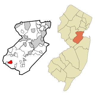
Princeton Meadows is an unincorporated community and census-designated place (CDP) located within Plainsboro Township, in Middlesex County, in the U.S. state of New Jersey. As of the 2010 United States Census, the CDP's population was 13,834.

<span class="mw-page-title-main">Dulce, New Mexico</span> Census-designated place in New Mexico, United States

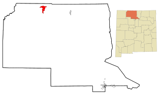
Dulce is a census-designated place (CDP) in Rio Arriba County, New Mexico, United States. The population was 2,743 at the 2010 census, almost entirely Native American. It is the largest community and tribal headquarters of the Jicarilla Apache Reservation.

<span class="mw-page-title-main">Angola on the Lake, New York</span> Census-designated place in New York, United States

Angola on the Lake is a hamlet and census-designated place (CDP) in Erie County, New York, United States. The population was 1,675 at the 2010 census. It is part of the Buffalo–Niagara Falls Metropolitan Statistical Area.

<span class="mw-page-title-main">Woodlawn, North Carolina</span> Census-designated place in North Carolina, United States

Woodlawn is a census-designated place in Alamance County, North Carolina, United States.

<span class="mw-page-title-main">Curtisville, Pennsylvania</span> Census-designated place in Pennsylvania, United States

Curtisville is a census-designated place (CDP) in Allegheny County, Pennsylvania, United States. The population was 1,097 at the 2020 census.

<span class="mw-page-title-main">Russellton, Pennsylvania</span> Census-designated place in Pennsylvania, United States

Russellton is a census-designated place (CDP) in Allegheny County, Pennsylvania, United States. The population was 1,330 at the 2020 census.

<span class="mw-page-title-main">Orchard Hills, Pennsylvania</span> Census-designated place in Pennsylvania, United States

Orchard Hills is a census-designated place (CDP) in Armstrong County, Pennsylvania, United States. The population was 1,949 at the 2020 census.

Woodland Heights is a census-designated place (CDP) in Venango County, Pennsylvania, United States. The population was 1,402 at the 2000 census.

<span class="mw-page-title-main">Sheffield, Pennsylvania</span> Census-designated place in Pennsylvania, United States

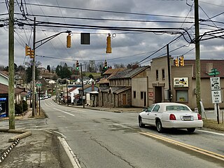
Sheffield is a census-designated place (CDP) within Sheffield Township in southeastern Warren County, Pennsylvania, United States. It is named after Sheffield, England. The population was 1,123 at the 2010 census.

<span class="mw-page-title-main">Harrison City, Pennsylvania</span> Census-designated place in Pennsylvania, United States

Harrison City is a census-designated place (CDP) in Westmoreland County, Pennsylvania, United States. The population was 174 at the 2020 census.

Loyalhanna is a census-designated place (CDP) in Westmoreland County, Pennsylvania, United States. The population was 3,415 at the 2000 census, at which time it was listed as McChesneytown-Loyalhanna, before just becoming the CDP of Loyalhanna for the 2010 census. As of the 2010 census the population was 3,428 residents.

<span class="mw-page-title-main">Fieldale, Virginia</span> CDP in Virginia, United States

Fieldale is a census-designated place (CDP) in Henry County, Virginia, United States. The population was 879 at the 2010 census. It is part of the Martinsville Micropolitan Statistical Area.

<span class="mw-page-title-main">Stanleytown, Virginia</span> CDP in Virginia, United States

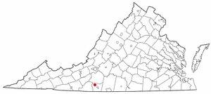
Stanleytown is a census-designated place (CDP) in Henry County, Virginia, United States. The population was 1,422 at the 2010 census. It is part of the Martinsville Micropolitan Statistical Area.

Villa Heights is a census-designated place (CDP) in Henry County, Virginia, United States. The population was 717 at the 2010 census. It is part of the Martinsville Micropolitan Statistical Area.

<span class="mw-page-title-main">Potter Lake, Wisconsin</span> CDP in Wisconsin, United States

Potter Lake is a census-designated place (CDP) in the town of East Troy, Walworth County, Wisconsin, United States. The population was 1,117 at the 2020 census.

<span class="mw-page-title-main">Cheektowaga (CDP), New York</span> Census-designated place in New York, United States

Cheektowaga is a suburban community and census-designated place (CDP) in Erie County, New York, United States. The population was 75,178 at the 2010 census, making it the most populous census-designated place in New York. It is within the town of Cheektowaga. The CDP includes Buffalo Niagara International Airport.

<span class="mw-page-title-main">Brattleboro (CDP), Vermont</span> CDP in Vermont, United States

Brattleboro is a census-designated place (CDP) corresponding to the densely populated core of the town of Brattleboro in Windham County, Vermont, United States. The population was 8,289 at the 2000 census.

References

  1. 1 2 "U.S. Census website". United States Census Bureau . Retrieved January 31, 2008.
  2. "US Board on Geographic Names". United States Geological Survey. October 25, 2007. Retrieved January 31, 2008.
  3. "National Register Information System". National Register of Historic Places . National Park Service. July 9, 2010.
  4. "US Gazetteer files: 2010, 2000, and 1990". United States Census Bureau. February 12, 2011. Retrieved April 23, 2011.