
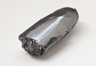
Iridium is a chemical element with the symbol Ir and atomic number 77. A very hard, brittle, silvery-white transition metal of the platinum group, it is considered the second-densest naturally occurring metal with a density of 22.56 g/cm3 (0.815 lb/cu in) as defined by experimental X-ray crystallography. It is one of the most corrosion-resistant metals, even at temperatures as high as 2,000 °C (3,630 °F). However, corrosion-resistance is not quantifiable in absolute terms; although only certain molten salts and halogens are corrosive to solid iridium, finely divided iridium dust is much more reactive and can be flammable, whereas gold dust is not flammable but can be attacked by substances that iridium resists, such as aqua regia.

Osmium is a chemical element with the symbol Os and atomic number 76. It is a hard, brittle, bluish-white transition metal in the platinum group that is found as a trace element in alloys, mostly in platinum ores. Osmium is the densest naturally occurring element. When experimentally measured using X-ray crystallography, it has a density of 22.59 g/cm3. Manufacturers use its alloys with platinum, iridium, and other platinum-group metals to make fountain pen nib tipping, electrical contacts, and in other applications that require extreme durability and hardness.

Platinum is a chemical element with the symbol Pt and atomic number 78. It is a dense, malleable, ductile, highly unreactive, precious, silverish-white transition metal. Its name originates from Spanish platina, a diminutive of plata "silver".
Ruthenium is a chemical element with the symbol Ru and atomic number 44. It is a rare transition metal belonging to the platinum group of the periodic table. Like the other metals of the platinum group, ruthenium is inert to most other chemicals. Russian-born scientist of Baltic-German ancestry Karl Ernst Claus discovered the element in 1844 at Kazan State University and named ruthenium in honor of Russia. Ruthenium is usually found as a minor component of platinum ores; the annual production has risen from about 19 tonnes in 2009 to some 35.5 tonnes in 2017. Most ruthenium produced is used in wear-resistant electrical contacts and thick-film resistors. A minor application for ruthenium is in platinum alloys and as a chemistry catalyst. A new application of ruthenium is as the capping layer for extreme ultraviolet photomasks. Ruthenium is generally found in ores with the other platinum group metals in the Ural Mountains and in North and South America. Small but commercially important quantities are also found in pentlandite extracted from Sudbury, Ontario, and in pyroxenite deposits in South Africa.

The Americas, sometimes collectively called America, are a landmass comprising the totality of North and South America. The Americas make up most of the land in Earth's Western Hemisphere and comprise the New World.

Earthquakes are caused by movements within the Earth's crust and uppermost mantle. They range from events too weak to be detectable except by sensitive instrumentation, to sudden and violent events lasting many minutes which have caused some of the greatest disasters in human history. Below, earthquakes are listed by period, region or country, year, magnitude, cost, fatalities and number of scientific studies.

The Geographic Names Information System (GNIS) is a database of name and location information about more than two million physical and cultural features throughout the United States and its territories, Antarctica, and the associated states of the Marshall Islands, Federated States of Micronesia, and Palau. It is a type of gazetteer. It was developed by the United States Geological Survey (USGS) in cooperation with the United States Board on Geographic Names (BGN) to promote the standardization of feature names.
The platinum-group metals (PGMs), also known as the platinoids, platinides, platidises, platinum group, platinum metals, platinum family or platinum-group elements (PGEs), are six noble, precious metallic elements clustered together in the periodic table. These elements are all transition metals in the d-block.

The National Map is a collaborative effort of the United States Geological Survey (USGS) and other federal, state, and local agencies to improve and deliver topographic information for the United States. The purpose of the effort is to provide "...a seamless, continuously maintained set of public domain geographic base information that will serve as a foundation for integrating, sharing, and using other data easily and consistently".
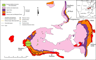
The Bushveld Igneous Complex (BIC) is the largest layered igneous intrusion within the Earth's crust. It has been tilted and eroded forming the outcrops around what appears to be the edge of a great geological basin: the Transvaal Basin. It is approximately 2 billion years old and is divided into four different limbs: the northern, southern, eastern, and western limbs. The Bushveld Complex comprises the Rustenburg Layered suite, the Lebowa Granites and the Rooiberg Felsics, that are overlain by the Karoo sediments. The site was first publicised around 1897 by Gustaaf Molengraaff who found the native South African tribes residing in and around the area.

Tukgahgo Mountain (TUG-a-ho) is a mountain in the Takshanuk Mountains in the U.S. state of Alaska with a peak elevation of 4,675 feet (1,425 m). It is located in Haines Borough, 3.5 miles (5.6 km) to the southwest of Chilkoot Lake and 16 miles (26 km) to the southwest of Skagway. Geological investigations of the veins in the mountain have revealed silver, gold, platinum, and palladium mineralization, derived from mid-Cretaceous events.

Mining in South Africa was once the main driving force behind the history and development of Africa's most advanced and richest economy. Large-scale and profitable mining started with the discovery of a diamond on the banks of the Orange River in 1867 by Erasmus Jacobs and the subsequent discovery of the Kimberley pipes a few years later. Gold rushes to Pilgrim's Rest and Barberton were precursors to the biggest discovery of all, the Main Reef/Main Reef Leader on Gerhardus Oosthuizen's farm Langlaagte, Portion C, in 1886, the Witwatersrand Gold Rush and the subsequent rapid development of the gold field there, the biggest of them all.
The mineral industry of Russia is one of the world's leading mineral industries and accounts for a large percentage of the Commonwealth of Independent States' production of a range of mineral products, including metals, industrial minerals, and mineral fuels. In 2005, Russia ranked among the leading world producers or was a significant producer of a vast range of mineral commodities, including aluminum, arsenic, cement, copper, magnesium compounds and metals, nitrogen, palladium, silicon, nickel and vanadium.
Mining in the United States has been active since the beginning of colonial times, but became a major industry in the 19th century with a number of new mineral discoveries causing a series of mining rushes. In 2015, the value of coal, metals, and industrial minerals mined in the United States was US $109.6 billion. 158,000 workers were directly employed by the mining industry.

The United States Geological Survey (USGS), founded as the Geological Survey, is an agency of the United States government whose work spans the disciplines of biology, geography, geology, and hydrology. The agency was founded on March 3, 1879, to study the landscape of the United States, its natural resources, and the natural hazards that threaten it. The agency also makes maps of extraterrestrial planets and moons based on data from U.S. space probes.

The Middle Fork Clearwater River is a short, but high volume river in Idaho County, Idaho, United States and is the major source of the Clearwater River, a tributary of the Snake River.
The Advanced National Seismic System (ANSS) is a collaboration of the U.S. Geological Survey (USGS) and regional, state, and academic partners that collects and analyzes data on significant earthquakes to provide near real-time information to emergency responders and officials, the news media, and the public. Such information is used to anticipate the likely severity and extent of damage, and to guide decisions on the responses needed.
