Related Research Articles

Clay County is a county located in the U.S. state of Indiana. As of 2020, the population was 26,466. The county seat is Brazil.
Vigo County is a county on the western border of the U.S. state of Indiana. According to the 2020 United States Census, it had a population of 106,153. Its county seat is Terre Haute.

Vermillion County lies in the western part of the U.S. state of Indiana between the Illinois border and the Wabash River. As of the 2020 census, the population was 15,439. The county seat is Newport. It was officially established in 1824 and was the fiftieth Indiana county created. Vermillion County is included in the Terre Haute, Indiana, Metropolitan Statistical Area. The county contains seven incorporated towns with a total population of about 9,900. as well as several unincorporated communities; it is also divided into five townships which provide local services. An interstate highway, two U.S. routes, and five state roads cross the county, as does a major railroad line.

Sullivan County is a county in the U.S. state of Indiana, and determined by the US Census Bureau to include the mean center of U.S. population in 1940. As of 2020, the population was 20,758. The county seat is Sullivan.

Parke County lies in the western part of the U.S. state of Indiana along the Wabash River. The county was formed in 1821 out of a portion of Vigo County. According to the 2020 census, the population was 16,156. The county seat is Rockville.

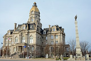
Terre Haute is the city that holds the county seat of Vigo County, Indiana, United States, about 5 miles (8 km) east of the state's western border with Illinois. As of the 2020 census, the city had a population of 58,389 and its metropolitan area had a population of 168,716.

West Terre Haute is a town in Sugar Creek Township, Vigo County, Indiana, on the western side of the Wabash River near Terre Haute. The population was 2,236 at the 2010 census. It is part of the Terre Haute Metropolitan Statistical Area. Bethany Congregational Church was placed on the National Register of Historic Places in 2003.
Headquartered in Indianapolis, Indiana, the Crossroads of America Council ( #160) serves Scouts and Scouters in Central Indiana. It was initially formed when Central Indiana Council, Delaware County Council, Kikthawenund Council, and Whitewater Valley Council merged in 1972. Recently, in the past decade, Wabash Valley and Crossroads of America were merged to form the new Crossroads of America Council, serving 25 counties in Indiana, extending from the Illinois state line to the Ohio state line. As of the end of 2012, the council served more than 36,000 youth thanks to more than 9,000 volunteer leaders.
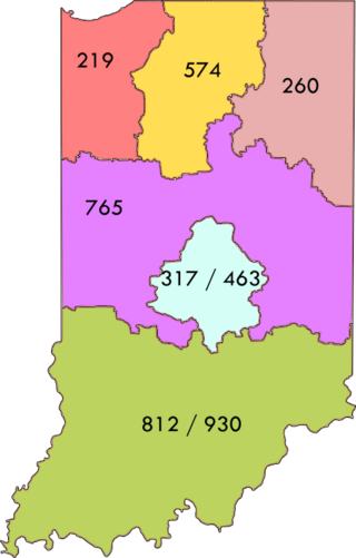
Area codes 812 and 930 are telephone area codes in the North American Numbering Plan (NANP) for the southern third of the state of Indiana.

The Wabash Valley is a region located in sections of both Illinois and Indiana. It is named for the Wabash River and, as the name is typically used, spans the middle to the middle-lower portion of the river's valley and is centered at Terre Haute, Indiana. The term Wabash Valley is frequently used in local media in Clinton, Lafayette, Mount Carmel, Princeton, Terre Haute, and Vincennes all of which are either on or near the Lower Wabash River.

Saint Mary-of-the-Woods, often called St. Mary's, is an unincorporated community in Sugar Creek Township in northwestern Vigo County, in the U.S. state of Indiana. The community is part of the Terre Haute Metropolitan Statistical Area. A large portion of Saint Mary-of-the-Woods along U.S. Route 150 is taken up by the grounds of the Sisters of Providence of Saint Mary-of-the-Woods, which contain the motherhouse of the Sisters of Providence as well as Saint Mary-of-the-Woods College. Although Saint Mary-of-the-Woods is unincorporated, it has a post office, with the ZIP code of 47876. It had a population of 797 at the 2010 census.

Harrison Township is one of twelve townships in Vigo County, Indiana, United States. As of the 2010 census, its population was 51,272 and it contained 22,940 housing units. It is entirely contained in Terre Haute's city limits, thus explaining why it is both the most densely populated and the most populated overall.
The Tribune-Star is a seven-day morning daily newspaper based in Terre Haute, Indiana, covering the Wabash Valley area of Indiana and Illinois. It is owned by Community Newspaper Holdings. Counties within the newspaper's coverage areas include Clay, Greene, Parke, Sullivan, Vermillion and Vigo counties, Indiana, and Clark, Crawford and Edgar counties, Illinois. It was preceded by The Tribune.
Terre Haute South Vigo High School is a public high school located in Terre Haute, Indiana. As the name implies, the school's district covers the southern portion of Terre Haute, as well as most of southern Vigo County, the county in which Terre Haute is located.

Indiana's 8th congressional district is a congressional district in the U.S. state of Indiana. Based in southwest and west central Indiana, the district is anchored in Evansville and also includes Jasper, Princeton, Terre Haute, Vincennes, and Washington.

Otter Creek Township is one of twelve townships in Vigo County, Indiana, United States. As of the 2010 census, its population was 9,069 and it contained 3,917 housing units.

Riley Township is one of twelve townships in Vigo County, Indiana, United States. As of the 2010 census, its population was 3,123 and it contained 1,260 housing units.

U.S. Route 150 (US 150) in Indiana is a 176.315-mile-long (283.751 km) east–west highway that travels from the Illinois state line east of Paris, Illinois to Louisville, Kentucky at the Kentucky state line. A section of US 150 from New Goshen to Vincennes travels north–south instead of east–west. US 150 travels concurrently with its parent route, US 50, from Vincennes to Shoals. Between West Terre Haute and Terre Haute, US 150 travels along part of the historic National Road. Also, from Vincennes to New Albany, the route is designated as part of Indiana's Historic Pathways, as it roughly parallels what was then part of the Buffalo Trace.
References
- ↑ "Southeast School Corporation" . Retrieved 21 June 2011.
- ↑ "Northeast School Corporation" . Retrieved 21 June 2011.
- ↑ "Clay Community Schools" . Retrieved 21 June 2011.
- ↑ "North Vermillion Community School Corporation" . Retrieved 21 June 2011.
- ↑ "South Vermillion Community School Corporation" . Retrieved 21 June 2011.
- ↑ "John Paul II Catholic High School" . Retrieved 21 June 2011.