Loma Linda, Missouri

Last updated

Loma Linda, Missouri
Newton County Missouri Incorporated and Unincorporated areas Loma Linda Highlighted.svg
Location of Loma Linda, Missouri
Coordinates: 36°59′34″N94°35′43″W / 36.99278°N 94.59528°W / 36.99278; -94.59528
Country United States
State Missouri
County Newton
Area
[1]
  Total3.56 sq mi (9.23 km2)
  Land3.56 sq mi (9.21 km2)
  Water0.01 sq mi (0.02 km2)
Elevation
[2]
1,070 ft (330 m)
Population
 (2020)
  Total943
  Density265.19/sq mi (102.38/km2)
Time zone UTC-6 (Central (CST))
  Summer (DST) UTC-5 (CDT)
FIPS code 29-43672 [3]
GNIS feature ID2396722 [2]
Website http://www.lomalinda-mo.us/index.php

Loma Linda is a town in Newton County, Missouri, United States. The population was 725 at the 2010 census. It is part of the Joplin, Missouri Metropolitan Statistical Area.

Contents

History

The village, a collection of homes and properties surrounding the golf course and country club of the name, was incorporated in 1995. Loma Linda Country Club was created by Joe Blau of New York and the late Ted Hoffman in 1971. Until August 2005, the golf professional at Loma Linda was Benny Pell.[ citation needed ]

On January 1, 2006, the course, Village Water Company, and the surrounding 2,500 acres (10 km2) area were sold to Joplin businessman Bobby Landis. Landis had acquired the resort and apartment complex of Loma Linda by the end of 2005.[ citation needed ] In 2007, the Country Club was sold to the Downstream Casino and Resort [4] owned and operated by the Quapaw Tribe. The tribe also owns a casino less than a mile west of the Loma Linda property. [4] The country club was split into three golf courses: The Eagle Creek Golf Club at Downstream Casino Resort, Bald Eagle Golf Course, and Golden Eagle Golf Courses. [4]

Loma Linda is part of the Seneca R-7 school district. [5]

Geography

According to the United States Census Bureau, the village has a total area of 3.57 square miles (9.25 km2), of which 3.56 square miles (9.22 km2) is land and 0.01 square miles (0.03 km2) is water. [6]

Demographics

Historical population
CensusPop.Note
2000 507
2010 72543.0%
2020 94330.1%
U.S. Decennial Census

2010 census

At the 2010 census, [7] there were 725 people, 302 households and 241 families residing in the village. The population density was 203.7 inhabitants per square mile (78.6/km2). There were 327 housing units at an average density of 91.9 per square mile (35.5/km2). The racial makeup of the village was 89.0% White, 2.6% African American, 4.7% Native American, 1.1% Asian, 0.3% Pacific Islander, 0.1% from other races, and 2.2% from two or more races. Hispanic or Latino of any race were 2.8% of the population.

There were 302 households, of which 25.5% had children under the age of 18 living with them, 73.5% were married couples living together, 4.0% had a female householder with no husband present, 2.3% had a male householder with no wife present, and 20.2% were non-families. 16.9% of all households were made up of individuals, and 4.6% had someone living alone who was 65 years of age or older. The average household size was 2.40 and the average family size was 2.66.

The median age in the village was 50.4 years. 18.6% of residents were under the age of 18; 4.7% were between the ages of 18 and 24; 19.3% were from 25 to 44; 38.1% were from 45 to 64; and 19.2% were 65 years of age or older. The gender makeup of the village was 50.9% male and 49.1% female.

2000 census

At the 2000 census, [3] there were 507 people, 203 households and 169 families residing in the town. The population density was 141.1 inhabitants per square mile (54.5/km2). There were 220 housing units at an average density of 61.2 per square mile (23.6/km2). The racial makeup of the town was 96.25% White, 0.79% African American, 1.78% Native American, 0.39% Asian, 0.20% from other races, and 0.59% from two or more races. Hispanic or Latino of any race were 1.58% of the population.

There were 203 households, of which 28.6% had children under the age of 18 living with them, 74.9% were married couples living together, 4.4% had a female householder with no husband present, and 16.7% were non-families. 12.8% of all households were made up of individuals, and 3.0% had someone living alone who was 65 years of age or older. The average household size was 2.50 and the average family size was 2.72.

20.3% of the population were under the age of 18, 5.3% from 18 to 24, 26.8% from 25 to 44, 34.5% from 45 to 64, and 13.0% who were 65 years of age or older. The median age was 44 years. For every 100 females, there were 105.3 males. For every 100 females age 18 and over, there were 106.1 males.

The median household income was $53,750 and the median family income was $61,250. Males had a median income of $52,188 compared with $26,500 for females. The per capita income for the town was $28,583. About 1.2% of families and 1.4% of the population were below the poverty line, including none of those under the age of eighteen or sixty-five or over.

Related Research Articles

<span class="mw-page-title-main">Newton County, Missouri</span> County in Missouri, United States

Newton County is a county located in the southwest portion of the U.S. state of Missouri. As of the 2020 census, the population was 58,648. Its county seat is Neosho. The county was organized in 1838 and is named in honor of John Newton, a hero who fought in the Revolutionary War.

<span class="mw-page-title-main">Rising Sun, Indiana</span> City in Indiana, United States

Rising Sun is a city in Randolph Township and the county seat of Ohio County, Indiana, United States, along the Ohio River. It is also the only incorporated community in the county. The population of Rising Sun was 2,304 at the 2010 census.

<span class="mw-page-title-main">French Lick, Indiana</span> Town in Indiana, United States

French Lick is a town in French Lick Township, Orange County, Indiana. The population was 1,722 at the time of the 2020 census.

<span class="mw-page-title-main">Larchwood, Iowa</span> City in Iowa, United States

Larchwood is a city in Lyon County, Iowa, United States. The population was 926 at the time of the 2020 census.

<span class="mw-page-title-main">Augusta, Michigan</span> Village in Michigan, United States

Augusta is a village in Kalamazoo County in the U.S. state of Michigan. The population was 885 at the 2010 census. The village is mostly within Ross Township, though a small portion extends south into Charleston Township.

<span class="mw-page-title-main">Rothbury, Michigan</span> Village in Michigan, United States

Rothbury is a village in Grant Township, Oceana County in the U.S. state of Michigan. The population was 486 at the 2010 census.

<span class="mw-page-title-main">Breezy Point, Minnesota</span> City in Minnesota, United States

Breezy Point is a city in Crow Wing County, Minnesota, United States. It is part of the Brainerd Micropolitan Statistical Area. The population was 2,346 at the 2010 census.

<span class="mw-page-title-main">Brooklyn Heights, Missouri</span> Village in Missouri, United States

Brooklyn Heights is a village in Jasper County, Missouri, United States. The population was 101 at the 2020 census. It is part of the Joplin, Missouri Metropolitan Statistical Area.

<span class="mw-page-title-main">Duquesne, Missouri</span> City in Missouri, United States

Duquesne is a Fourth-Class City in Jasper County, Missouri, United States. The population was 2,159 at the 2020 census. It is part of the Joplin, Missouri Metropolitan Statistical Area.

<span class="mw-page-title-main">Fidelity, Missouri</span> Village in Missouri, United States

Fidelity is a village in Jasper County, Missouri, United States. The population was 227 at the 2020 census. It is part of the Joplin, Missouri Metropolitan Statistical Area.

<span class="mw-page-title-main">Wentworth, Missouri</span> Village in Missouri, United States

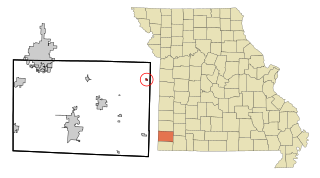
Wentworth is a village in northeastern Newton County, Missouri, United States. The population was 151 at the 2010 census. It is part of the Joplin, Missouri Metropolitan Statistical Area.

<span class="mw-page-title-main">Innsbrook, Missouri</span> Village in Missouri, United States

Innsbrook is a village in Warren County, Missouri, United States. The population was 552 at the 2010 census. The village of Innsbrook is comprised almost entirely by Innsbrook Resort—a private, gated community. The village was founded in 1998.

<span class="mw-page-title-main">Ritchey, Missouri</span> Town in Missouri, United States

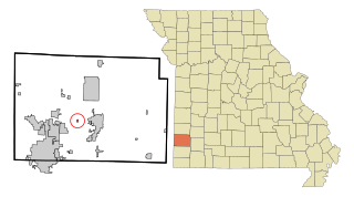
Ritchey is a village in Newton County, Missouri, United States. The population was 82 at the 2010 census. It is part of the Joplin, Missouri Metropolitan Statistical Area.

<span class="mw-page-title-main">Silver Creek, Missouri</span> Neighborhood in Newton, Missouri, United States

Silver Creek was a village in Newton County, Missouri, United States. The population was 623 at the 2010 census. It is part of the Joplin, Missouri Metropolitan Statistical Area. On August 7, 2012, residents of the Village of Silver Creek and the City of Joplin voted to consolidate and become part of the city of Joplin.

<span class="mw-page-title-main">Santa Ana Pueblo, New Mexico</span> CDP in New Mexico, United States

Santa Ana Pueblo is a census-designated place (CDP) in Sandoval County, New Mexico, United States. As of the 2000 census, the CDP had a total population of 479. It is part of the Albuquerque Metropolitan Statistical Area. The Pueblo, named Tamaya in Keres, administers a total reservation land of 73,000 acres (295 km2) in the Rio Grande valley and is composed of Native Americans who speak an eastern dialect of the Keresan languages.

<span class="mw-page-title-main">Waynesfield, Ohio</span> Village in Ohio, United States

Waynesfield is a village in Auglaize County, Ohio, United States. The population was 749 at the 2020 census. It is included in the Wapakoneta, Ohio Micropolitan Statistical Area.

<span class="mw-page-title-main">Golf Manor, Ohio</span> Village in Ohio, United States

Golf Manor is a village in Hamilton County, Ohio, United States. It is almost completely surrounded by the Pleasant Ridge and Roselawn neighborhoods of Cincinnati. The population was 3,814 at the 2020 census.

<span class="mw-page-title-main">Loma Linda East, Texas</span> Census-designated place in Texas, United States

Loma Linda East is a census-designated place (CDP) in Jim Wells County, Texas, United States. The population was 254 at the 2010 census, up from 214 at the 2000 census.

<span class="mw-page-title-main">Del Sol-Loma Linda, Texas</span> Former CDP in Texas, United States

Del Sol-Loma Linda is a census-designated place (CDP) in San Patricio County, Texas, United States. The population was 726 at the 2000 U.S. Census.

<span class="mw-page-title-main">Loma Linda, California</span> City in California, United States

Loma Linda is a city in San Bernardino County, California, United States, that was incorporated in 1970. The population was 24,791 at the 2020 census, up from 23,261 at the 2010 census. The central area of the city was originally known as Mound City, while its eastern half was originally the unincorporated community of Bryn Mawr.

References

  1. "ArcGIS REST Services Directory". United States Census Bureau. Retrieved August 28, 2022.
  2. 1 2 U.S. Geological Survey Geographic Names Information System: Loma Linda, Missouri
  3. 1 2 "U.S. Census website". United States Census Bureau . Retrieved January 31, 2008.
  4. 1 2 3 "Sale of Loma Linda Country Club to Downstream Casino Resort complete". Joplin Globe. Retrieved January 20, 2017.
  5. "Town of Loma Linda - City Services". www.lomalinda-mo.us. Retrieved January 20, 2017.
  6. "US Gazetteer files 2010". United States Census Bureau. Archived from the original on January 25, 2012. Retrieved July 8, 2012.
  7. "U.S. Census website". United States Census Bureau . Retrieved July 8, 2012.