Stella, Missouri

Last updated
Stella, Missouri
Lentz-Carter Merchandise Store.jpg
Historic Lentz-Carter Merchandise Store
Newton County Missouri Incorporated and Unincorporated areas Stella Highlighted.svg
Location of Stella, Missouri
Coordinates: 36°45′45″N94°11′28″W / 36.76250°N 94.19111°W / 36.76250; -94.19111 Coordinates: 36°45′45″N94°11′28″W / 36.76250°N 94.19111°W / 36.76250; -94.19111 [1]
Country United States
State Missouri
County Newton
Area
[2]
  Total0.16 sq mi (0.42 km2)
  Land0.16 sq mi (0.42 km2)
  Water0.00 sq mi (0.00 km2)
Elevation
[1]
1,155 ft (352 m)
Population
 (2020)
  Total166
  Density1,018.40/sq mi (392.12/km2)
Time zone UTC-6 (Central (CST))
  Summer (DST) UTC-5 (CDT)
ZIP code
64867
Area code 417
FIPS code 29-70648 [3]
GNIS feature ID2397681 [1]

Stella is a village in southern Newton County, Missouri, United States. The population was 158 at the 2010 census. It is part of the Joplin, Missouri Metropolitan Statistical Area. The village of Stella is located 17 miles southeast of Neosho.

Contents

History

The first known settlers of this area arrived in the early 1820s. The area of Stella was previously a fishing community called Springs. In October 1880, the St. Louis and San Francisco Railroad sold a portion of what became Stella to Moses Eagle for $200. Moses Eagle's family arrived in the area in 1844. Stella became an incorporated town in 1930. The village was named after Moses Eagle's granddaughter. The water-powered grist mill was built in 1867 by Eagle. The Bank of Stella was established circa 1900. The area's first newspaper, the Amicus Curio, was started in 1901 by a doctor from Kent, Missouri, with the Stella Enterprise and the Stella Weekly Record established after that. The Horner Institute merged with the Stella Academy in 1911 and was located there until moving to Purdy in 1912. The Stella Baptist Church was established in 1886, with the actual church built circa 1911, the Stella Methodist Church circa 1896, while the Stella Church of Christ was established after 1950. [4]

The Lentz-Carter Merchandise Store was listed on the National Register of Historic Places in 2008. [5]

Cardwell Hospital

Clarence C. Cardwell

Despite Stella's small size, for nearly 60 years the Cardwell Hospital, later the Cardwell Memorial Osteopathic Hospital, attracted people from the largely rural surrounding areas of Newton County, Barry County and McDonald County for their healthcare needs. Cardwell Hospital was opened in 1920 by World War I veteran Clarence C. Cardwell, who had been born only two miles outside of Stella in 1892. [6] At first the hospital was only four rooms, [6] but later expanded to meet the needs of the local community. By 1930 a second doctor had joined the staff at Cardwell and it had 10 beds available for patients. [7] A fire in 1942 damaged the hospital, but Cardwell quickly had the building rebuilt. [8] Cardwell continued running the hospital with his wife, Ida Cardwell, and their daughter, Cleta Cardwell, until his death in November 1956. [9] At the time of his death the Cardwell Hospital was reported to have grown to 100 beds. [9]

Following Cardwell's death in November 1956, the Cardwell Hospital was closed for a short time, until it was purchased from Ida and Cleta Cardwell by Silas and Lillian Fountain and reopened on February 11, 1957, as the Cardwell Memorial Osteopathic Hospital. [8] The Fountains, a married couple from Sulphur Springs, Arkansas, had both graduated from the Kansas City College of Osteopathy and Surgery. [10] Their daughter Mary Sue Fountain served as the hospital administrator. [8] Following her husband's death on June 29, 1973, Lillian Fountain continued running the hospital until 1977. Lillian Fountain died on October 13, 1996. [10]

Hospital closure and EPA clean up

The former Cardwell Hospital in Stella, Missouri in 2004, shortly before it was torn down and removed because of asbestos contamination. Cardwell Hospital in Stella, Missouri.jpg
The former Cardwell Hospital in Stella, Missouri in 2004, shortly before it was torn down and removed because of asbestos contamination.

Cardwell Memorial Osteopathic Hospital closed in 1977, but the building was soon reopened as a residential care facility owned by Don and Vera Littlefield. But this venture proved short lived and the building was vacant by the mid-1980s. [8] After sitting empty for nearly 20 years, the residents of Stella, seeking to revive the town's business district, proposed a plan to convert the empty hospital building into a multipurpose building complex, which would house a clinic, a library, city hall, retail space and residential units. [11] However, due to considerable asbestos contamination at the site, the decision was made to remove the now derelict structure. [11] Because of the nature of the contamination, the Environmental Protection Agency declared the former Cardwell Hospital building a superfund site and assisted the town in removing it. [12] In the summer of 2006, the former Cardwell Hospital was torn down and the site was decontaminated, making it safe for other uses. [13] Following the removal of the building, the site was redeveloped as the Stella Veterans Memorial Park, which is dedicated to veterans from the Stella area. [14]

Community of doctors

During the years of the Cardwell Hospital, especially during Clarence Cardwell's ownership, the town of Stella is thought to have produced more than 30 doctors and dentists, most of which are believed to have had experience working in the former Cardwell Hospital during their youth. [8] [15]

Geography

Stella is located on the northeast side of South Indian Creek, one-half mile north of the Newton-McDonald county line. Access is via Missouri Routes O and F, and Missouri Route 76 passes approximately 2.5 miles to the south. [16]

According to the United States Census Bureau, the village has a total area of 0.16 square miles (0.41 km2), all land. [17]

Demographics

Historical population
CensusPop.Note
1930 226
1940 221−2.2%
1950 177−19.9%
1960 166−6.2%
1970 19718.7%
1980 23016.8%
1990 132−42.6%
2000 17834.8%
2010 158−11.2%
2020 1665.1%
U.S. Decennial Census

2010 census

As of the census [18] of 2010, there were 158 people, 65 households, and 40 families residing in the village. The population density was 987.5 inhabitants per square mile (381.3/km2). There were 83 housing units at an average density of 518.8 per square mile (200.3/km2). The racial makeup of the village was 89.9% White, 5.1% Native American, and 5.1% Asian. Hispanic or Latino of any race were 0.6% of the population.

There were 65 households, of which 36.9% had children under the age of 18 living with them, 44.6% were married couples living together, 13.8% had a female householder with no husband present, 3.1% had a male householder with no wife present, and 38.5% were non-families. 33.8% of all households were made up of individuals, and 17% had someone living alone who was 65 years of age or older. The average household size was 2.43 and the average family size was 3.20.

The median age in the village was 37.5 years. 27.8% of residents were under the age of 18; 10.2% were between the ages of 18 and 24; 22.3% were from 25 to 44; 25.3% were from 45 to 64; and 14.6% were 65 years of age or older. The gender makeup of the village was 48.7% male and 51.3% female.

2000 census

As of the census [3] of 2000, there were 178 people, 74 households, and 46 families residing in the town. The population density was 1,152.7 inhabitants per square mile (445.1/km2). There were 87 housing units at an average density of 563.4 per square mile (217.5/km2). The racial makeup of the town was 98.31% White, 0.56% Native American, and 1.12% from two or more races. Hispanic or Latino of any race were 1.12% of the population.

There were 74 households, out of which 29.7% had children under the age of 18 living with them, 48.6% were married couples living together, 9.5% had a female householder with no husband present, and 36.5% were non-families. 31.1% of all households were made up of individuals, and 17.6% had someone living alone who was 65 years of age or older. The average household size was 2.41 and the average family size was 2.98.

In the town the population was spread out, with 29.2% under the age of 18, 6.2% from 18 to 24, 29.8% from 25 to 44, 16.3% from 45 to 64, and 18.5% who were 65 years of age or older. The median age was 36 years. For every 100 females, there were 97.8 males. For every 100 females age 18 and over, there were 100.0 males.

The median income for a household in the town was $25,781, and the median income for a family was $25,417. Males had a median income of $27,813 versus $16,458 for females. The per capita income for the town was $11,799. About 14.6% of families and 12.4% of the population were below the poverty line, including 13.8% of those under the age of eighteen and 3.7% of those 65 or over.

Related Research Articles

<span class="mw-page-title-main">Newton County, Missouri</span> County in Missouri, United States

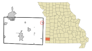
Newton County is a county located in the southwest portion of the U.S. state of Missouri. As of the 2010 census, the population was 58,114. Its county seat is Neosho. The county was organized in 1838 and is named in honor of John Newton, a hero who fought in the Revolutionary War.

<span class="mw-page-title-main">Wooldridge, Missouri</span> Village in Missouri, United States

Wooldridge is a village in northeastern Cooper County, Missouri, United States. The population was 61 at the 2010 census. On October 22, 2022, a large fire destroyed 23 buildings, about half the town.

<span class="mw-page-title-main">Arbyrd, Missouri</span> City in Missouri, United States

Arbyrd is a small town in southeast Dunklin County, Missouri, United States. The population was 404 at the 2020 census. The town was officially incorporated in 1919.

<span class="mw-page-title-main">Cardwell, Missouri</span> City in Missouri, United States

Cardwell is a city in southwest Dunklin County, Missouri, United States. The population was 713 at the 2010 census. The current Mayor of Cardwell is Brandon Cupp and the current aldermen are Harvey Beasley, Mike Clark, and Chuck Walls.

<span class="mw-page-title-main">Pierce City, Missouri</span> City in Missouri, United States

Pierce City, formerly Peirce City, is a city in southwest Lawrence and northwest Barry counties, in southwest Missouri, United States. The population was 1,292 at the 2010 census. In 2010, the town annexed property along Route 97 into Barry County to a point just north of U.S. Route 60. It was estimated to be 1,309 by the City of Pierce City as of July 1, 2019.

<span class="mw-page-title-main">Goodman, Missouri</span> City in Missouri, United States

Goodman is a city in McDonald County, Missouri, United States. The population was 1,248 at the 2010 census.

<span class="mw-page-title-main">Tuscumbia, Missouri</span> Town in Missouri, United States

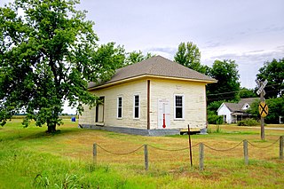
Tuscumbia is a town in and the county seat of Miller County, Missouri, United States. The population was 203 at the 2010 census, at which time it was a town.

<span class="mw-page-title-main">Fairview, Missouri</span> City in Missouri, United States

Fairview is a city in southeastern Newton County, Missouri, United States. The population was 383 at the 2010 census. It is part of the Joplin, Missouri Metropolitan Statistical Area.

<span class="mw-page-title-main">Grand Falls Plaza, Missouri</span> Village in Missouri, United States

Grand Falls Plaza is a village in Newton County, Missouri, United States. The population was 114 at the 2010 census, at which time it was a town. It is part of the Joplin, Missouri Metropolitan Statistical Area.

<span class="mw-page-title-main">Neosho, Missouri</span> City in Missouri, United States

Neosho is the most populous city in Newton County, Missouri, United States, which it serves as the county seat. With a population of 12,590 as of the 2020 census, the city is a part of the Joplin, Missouri Metropolitan Statistical Area, a region with an estimated 176,849 (2011) residents. Neosho lies on the western edge of the Ozarks, in the far southwest of the state.

<span class="mw-page-title-main">Newtonia, Missouri</span> Village in Missouri, United States

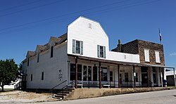
Newtonia is a village in Newton County, Missouri, United States. The population was 199 at the 2010 census. It is part of the Joplin, Missouri Metropolitan Statistical Area. Newtonia was the site of the Battles of Newtonia during the American Civil War. The village contains some Antebellum houses, such as the Mathew H. Ritchey House, as well as a cemetery for Civil War dead. It is a farming community and is immediately adjacent to Stark City, Missouri.

<span class="mw-page-title-main">Seneca, Missouri</span> City in Missouri, United States

Seneca is a city in western Newton County, Missouri, United States. The population was 2,336 at the 2010 census. Located on the southwest border of the state, the city is part of the Joplin, Missouri Metropolitan Statistical Area.

<span class="mw-page-title-main">Stark City, Missouri</span> Town in Missouri, United States

Stark City is a town in Newton County, Missouri, United States. The population was 139 at the 2010 census, at which time it was a town. It is part of the Joplin, Missouri Metropolitan Statistical Area. It is adjacent to the battlefield of the Second Battle of Newtonia.

<span class="mw-page-title-main">Wentworth, Missouri</span> Village in Missouri, United States

Wentworth is a village in northeastern Newton County, Missouri, United States. The population was 151 at the 2010 census. It is part of the Joplin, Missouri Metropolitan Statistical Area.

<span class="mw-page-title-main">Caledonia, Missouri</span> Village in Missouri, United States

Caledonia is a village in southern Washington County, Missouri, United States. The population was 131 at the 2020 census. Caledonia is located 4 miles (6.4 km) east of Belgrade.

<span class="mw-page-title-main">Stella, Nebraska</span> Village in Nebraska, United States

Stella is a village in Richardson County, Nebraska, United States. The population was 150 at the 2020 census.

<span class="mw-page-title-main">Diamond, Missouri</span> City in Missouri, United States

Diamond is a city in north central Newton County, Missouri, United States, located southeast of Joplin. The population was 902 at the 2010 census. It is part of the Joplin, Missouri, Metropolitan Statistical Area. Diamond is primarily renowned as the birthplace of George Washington Carver.

<span class="mw-page-title-main">Redings Mill, Missouri</span> Village in Missouri, United States

Redings Mill is a village in Newton County, Missouri, United States. The population was 151 at the 2010 census. It is part of the Joplin, Missouri Metropolitan Statistical Area.

<span class="mw-page-title-main">Ritchey, Missouri</span> Town in Missouri, United States

Ritchey is a village in Newton County, Missouri, United States. The population was 82 at the 2010 census. It is part of the Joplin, Missouri Metropolitan Statistical Area.

<span class="mw-page-title-main">Neosho, Wisconsin</span> Village in Wisconsin, United States

Neosho is a village in Dodge County, Wisconsin, United States. The population was 574 at the 2010 census.

References

  1. 1 2 3 U.S. Geological Survey Geographic Names Information System: Stella, Missouri
  2. "ArcGIS REST Services Directory". United States Census Bureau. Retrieved August 28, 2022.
  3. 1 2 "U.S. Census website". United States Census Bureau . Retrieved 2008-01-31.
  4. Blanche Pogue Clanton, ed. (1976). The Story of Stella: Pioneer Town of Newton County, Missouri. Noel, Missouri: Pogue Printing Company. pp. 5, 9, 10, 13, 17, 19, 29.
  5. "National Register Information System". National Register of Historic Places . National Park Service. July 9, 2010.
  6. 1 2 Newton County Highlights; by Neosho Christian Schools; 2002; Page 75
  7. Newton County Highlights; by Neosho Christian Schools; 2002; Pages 75 & 76
  8. 1 2 3 4 5 Newton County Highlights; by Neosho Christian Schools; 2002; Page 76
  9. 1 2 Cassville Republican; Obituaries; November 29, 1956
  10. 1 2 "Miscellaneous Jasper County, Missouri Obituaries".
  11. 1 2 "Cardwell Hospital Site, Stella, Missouri | Technical Assistance to Brownfields Communities". Archived from the original on 2013-04-09. Retrieved 2013-03-20.
  12. http://www.atsdr.cdc.gov/HAC/pha//FormerStellaCardwellHospital/FormerStellaCardwellHospitalLHC052208.pdf [ bare URL PDF ]
  13. Joplin Globe; Hospital being razed; July 26, 2006
  14. "Stella Veterans Memorial » Green Right Now". Archived from the original on 2013-04-11. Retrieved 2013-03-20.
  15. "McDonald County, Missouri Genealogy Trails".
  16. Stella, MO, 7.5 Minute Topographic Quadrangle, USGS, 1972
  17. "US Gazetteer files 2010". United States Census Bureau. Archived from the original on 2012-01-25. Retrieved 2012-07-08.
  18. "U.S. Census website". United States Census Bureau . Retrieved 2012-07-08.