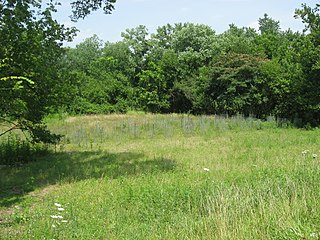
Madisonville is the type site for the Madisonville phase of Fort Ancient pottery. The 5-acre site is located on a bluff above the Little Miami River about 5 miles upstream from the Ohio River. While occupied over hundreds of years, it was settled most intensively in the late sixteenth and early seventeenth centuries, and is the most excavated Fort Ancient site of this time period.[3] Early twentieth-century excavations were carried out by staff of the Peabody Museum at Harvard University in Cambridge, Massachusetts.[4]
Since 1990, the Cincinnati Museum of Natural History has done additional studies, with findings increased by the use of current technology and professional practices. The village site was found to have had two or more small plazas, rather than just one central site, as seen at the earlier SunWatch Indian Village.
This is believed to be the only Fort Ancient site whose people consumed bison as part of the game hunted to supplement their diet of maize. They may have hunted the animals in areas to the west of this site. Elk and deer were also valuable for their meat. The people also processed their bones, tendons and hides to make tools, musical instruments, clothing, and ornaments.[3]
Researchers found a large amount of goods of non-local materials and design, indicating the villagers were connected to a large exchange network. Items were identified as from the St. Lawrence River region, on the New York and Canadian border, eastern present-day Iowa, and northern Alabama, as well as Tennessee. The size and limited range of European goods indicated they came from an indirect network at this time, rather than in direct trading. People at Madisonville made distinctive snake-shaped ornaments, which have been found at other sites as distant as Iroquois settlements in Ontario, Canada and western present-day New York.[3]
The Great Serpent Mound is a 1,348-foot-long (411 m), three-foot-high prehistoric effigy mound located in Peebles, Ohio. It was built on what is known as the Serpent Mound crater plateau, running along the Ohio Brush Creek in Adams County, Ohio. The mound is the largest serpent effigy in the world.
Fort Ancient is a name for a Native American culture that flourished from c. 1000–1750 CE and predominantly inhabited land near the Ohio River valley in the areas of modern-day southern Ohio, northern Kentucky, southeastern Indiana and western West Virginia. Although a contemporary of the Mississippian culture, they are often considered a "sister culture" and distinguished from the Mississippian culture. While far from agreed upon, there is evidence to suggest that the Fort Ancient Culture were not the direct descendants of the Hopewellian Culture. It is suspected that the Fort Ancient Culture introduced maize agriculture to Ohio. The Fort Ancient Culture were most likely the builders of the Great Serpent Mound. Recent archeological study and carbon dating suggests that Alligator Mound in Granville also dates to the Fort Ancient era, rather than the assumed Hopewell era. It is believed that neither the Serpent or Alligator Mounds are burial locations, but rather served as ceremonial effigy sites.
Fort Hawkins was a fort built between 1806 and 1810 in the historic Creek Nation by the United States government under President Thomas Jefferson and used until 1824. Built in what is now Georgia at the Fall Line on the east side of the Ocmulgee River, the fort overlooked the sacred ancient earthwork mounds of the Ocmulgee Old Fields, now known as the Ocmulgee Mounds National Historical Park. The Lower Creek Trading Path passed by just outside the fort's northwestern blockhouse, and continued in a westerly direction until it reached a natural ford on the Ocmulgee River. A trading settlement and later the city of Macon, Georgia, developed in the area prior to the construction of the fort, with British traders being in the area as early as the 1680s. Later, the fort would become important to the Creek Nation, the United States, and the state of Georgia for economic, military, and political reasons.
The Monongahela culture were an Iroquoian Native American cultural manifestation of Late Woodland peoples from AD 1050 to 1635 in present-day Western Pennsylvania, western Maryland, eastern Ohio, and West Virginia. The culture was named by Mary Butler in 1939 for the Monongahela River, whose valley contains the majority of this culture's sites.
The Grave Creek Mound in the Ohio River Valley in West Virginia is one of the largest conical-type burial mounds in the United States, now standing 62 feet (19 m) high and 240 feet (73 m) in diameter. The builders of the site, members of the Adena culture, moved more than 60,000 tons of dirt to create it about 250–150 BC.
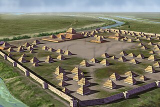
SunWatch Indian Village / Archaeological Park, previously known as the Incinerator Site, and designated by the Smithsonian trinomial 33-MY-57, is a reconstructed Fort Ancient Native American village next to the Great Miami River. The dwellings and site plan of the 3-acre (1.2 ha) site are based on lengthy archeological excavations sponsored by the Dayton Society of Natural History, which owns and operates the site as an open-air museum. Because of its archaeological value, the site was listed in 1974 on the National Register of Historic Places. Since that time, as the many years of archaeological research at the site have led to important findings about the Fort Ancient culture, SunWatch Indian Village was designated in 1990 as a National Historic Landmark.
The Grand Village of the Illinois, also called Old Kaskaskia Village, is a site significant for being the best documented historic Native American village in the Illinois River valley. It was a large agricultural and trading village of Native Americans of the Illinois confederacy, located on the north bank of the Illinois River near the present town of Utica, Illinois. French explorers Louis Joliet and Father Jacques Marquette came across it in 1673. The Kaskaskia, a tribe of the Illiniwek people lived in the village. It grew rapidly after a French mission and fur trading post were established there in 1675, to a population of about 6,000 people in about 460 houses. Around 1691 the Kaskaskia and other Illiniwek moved further south, abandoning the site due to pressure from an Iroquois invasion from the northeast.
The Clough Creek and Sand Ridge Archaeological District is a historic district composed of two archaeological sites in the southwestern part of the U.S. state of Ohio. Its name is derived from those of the two sites included in the district: one that lies along Clough Creek, and one that occupies part of the Sand Ridge near the creek.
The Mariemont Historic District is a National Historic Landmark District encompassing most of the municipality of Mariemont, Ohio, USA. Mariemont was planned and developed in the 1920s by philanthropist Mary Emery and landscape architect John Nolen, and was one of the nation's first planned suburban communities. Its architecture and streetscape are still strongly evocative of its original plans. A large portion of the community was listed on the National Register of Historic Places in 1979; a larger area was designated a National Historic Landmark in 2007.
The State Line Archeological District is a complex of archaeological sites and national historic district located west of Elizabethtown, Ohio, United States. Located on both sides of the Indiana/Ohio border, the historic district is composed of five contributing properties spread out across 8 acres (3.2 ha) of land. It is believed to have been the site of a village of the Fort Ancient culture of prehistoric Native Americans.
The Turpin site (33Ha19) is an archaeological site in the southwestern portion of the U.S. state of Ohio. Located near Newtown in Hamilton County, the site includes the remains of a village of the Fort Ancient culture and of multiple burial mounds. Numerous bodies have been found in and around the mounds as a result of thorough site investigations. The archaeological value of the site has resulted in its use in the study of similar locations and in its designation as a historic site.
Parkin Archeological State Park, also known as Parkin Indian Mound, is an archeological site and state park in Parkin, Cross County, Arkansas. Around 1350–1650 CE an aboriginal palisaded village existed at the site, at the confluence of the St. Francis and Tyronza rivers. Artifacts from this site are on display at the site museum. The Parkin site is the type site for the Parkin phase, an expression of the Mississippian culture from the Late Mississippian period. Many archeologists believe it to be part of the province of Casqui, documented as visited by Spanish explorer Hernando de Soto in 1542. Archeological artifacts from the village of the Parkin people are dated to 1400–1650 CE.
The Clover site (46CB40) is a Fort Ancient culture archeological site located near Lesage in Cabell County, West Virginia, United States. It is significant for its well-preserved remains of a late prehistoric/protohistoric Native American village. The site's unique assemblage has made it the type site for the Clover Phase of the Madisonville horizon of the Fort Ancient culture.
The Prehistory of West Virginia spans ancient times until the arrival of Europeans in the early 17th century. Hunters ventured into West Virginia's mountain valleys and made temporary camp villages since the Archaic period in the Americas. Many ancient human-made earthen mounds from various mound builder cultures survive, especially in the areas of Moundsville, South Charleston, and Romney. The artifacts uncovered in these areas give evidence of a village society with a tribal trade system culture that included limited cold worked copper. As of 2009, over 12,500 archaeological sites have been documented in West Virginia.
Prehistory of Ohio provides an overview of the activities that occurred prior to Ohio's recorded history. The ancient hunters, Paleo-Indians, descended from humans that crossed the Bering Strait. There is evidence of Paleo-Indians in Ohio, who were hunter-gatherers that ranged widely over land to hunt large game. For instance, mastodon bones were found at the Burning Tree Mastodon site that showed that it had been butchered. Clovis points have been found that indicate interaction with other groups and hunted large game. The Paleo Crossing site and Nobles Pond site provide evidence that groups interacted with one another. The Paleo-Indian's diet included fish, small game, and nuts and berries that gathered. They lived in simple shelters made of wood and bark or hides. Canoes were created by digging out trees with granite axes.
The Buffalo Indian Village Site is an archaeological site located near Buffalo, Putnam County, West Virginia, along the Kanawha River in the United States. This site sits atop a high terrace on the eastern bank of the Kanawha River and was once home to a variety of Native American villages including the Archaic, Middle Woodland and Fort Ancient cultures of this region. Buffalo Village was the site of one of the first systematic archaeological projects performed in West Virginia and it was added to the National Register of Historic Places in 1971.
The Hardin Village site (15GP22) is a Fort Ancient culture Montour Phase archaeological site located on a terrace of the Ohio River near South Shore in Greenup County, Kentucky. It is located within the Big Sandy Management Area along with the nearby Lower Shawneetown site. The site was first inhabited sometime in the early 16th century and abandoned by 1625. This era of protohistory saw the arrival of Europeans in North America, although by the time they made it to this area, the village had been long abandoned.
The Bentley site (15Gp15) is a Late Fort Ancient culture Madisonville horizon archaeological site overlain by an 18th-century Shawnee village; it is located within the Lower Shawneetown Archeological District, near South Portsmouth in Greenup County, Kentucky and Lewis County, Kentucky. It was added to the National Register of Historic Places on April 28, 1983. It is located near four groups of Hopewell tradition mounds, built between 100 BCE and 500 CE, known as the Portsmouth Earthworks.
Whittlesey culture is an archaeological designation for a Native American people, who lived in northeastern Ohio during the Late Precontact and Early Contact period between A.D. 1000 to 1640. By 1500, they flourished as an agrarian society that grew maize, beans, and squash. After European contact, their population decreased due to disease, malnutrition, and warfare. There was a period of long, cold winters that would have impacted their success cultivating food from about 1500.
The Hotel Plaza site (Ls-36) is located near Starved Rock, on the Illinois River across from the Zimmerman site (aka Grand Village of the Illinois. It is a multi-component site representing prehistoric, protohistoric and early historic periods, with the main occupation being an early Historic component associated with the French Fort St. Louis.
This page is based on this Wikipedia article Text is available under the CC BY-SA 4.0 license; additional terms may apply. Images, videos and audio are available under their respective licenses.