
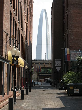
Gateway Arch National Park is an American national park located in St. Louis, Missouri, near the starting point of the Lewis and Clark Expedition.
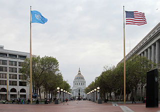
The Civic Center in San Francisco, California, is an area located a few blocks north of the intersection of Market Street and Van Ness Avenue that contains many of the city's largest government and cultural institutions. It has two large plazas and a number of buildings in classical architectural style. The Bill Graham Civic Auditorium, the United Nations Charter was signed in the Veterans Building's Herbst Theatre in 1945, leading to the creation of the United Nations. It is also where the 1951 Treaty of San Francisco was signed. The San Francisco Civic Center was designated a National Historic Landmark in 1987 and listed in the National Register of Historic Places on October 10, 1978.

MetroLink is a light rail system that serves the Greater St. Louis area. Operated by Metro Transit in a shared fare system with MetroBus, the two-line, 38-station system runs from St. Louis Lambert International Airport and Shrewsbury in Missouri to Scott Air Force Base in Illinois. Intermediate destinations include downtown Clayton, Forest Park, and downtown St. Louis. It is the only U.S. light rail system to cross state lines.

Transportation in Greater St. Louis, Missouri includes road, rail, ship, and air transportation modes connecting the bi-state St. Louis metropolitan area with surrounding communities throughout the Midwest, national transportation networks, and international locations. The Greater St. Louis region also supports a multi-modal transportation network that includes bus, paratransit, and light rail service in addition to shared-use paths, bike lanes and greenways.

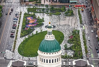
The Old St. Louis County Courthouse was built as a combination federal and state courthouse in St. Louis, Missouri, United States. Missouri's tallest habitable building from 1864 to 1894, it is now part of Gateway Arch National Park and operated by the National Park Service for historical exhibits and events.
Luther Ely Smith was a St. Louis, Missouri lawyer and civic booster. He has been described by the National Park Service as the "father of the Jefferson National Expansion Memorial," which was renamed as the Gateway Arch National Park in 2018. In the 1930s, he conceived of the idea of a memorial to President Thomas Jefferson in St. Louis, the starting point of the Lewis and Clark Expedition and opening of the West through the city. He chaired the Association to develop the memorial for nearly 15 years, every year but one from 1934 through 1949, after the design competition had been completed and the winner Eero Saarinen selected for his "Gateway Arch". Construction of the Gateway Arch started in 1963, after Smith's death; it fulfilled his vision of a symbol of the city to represent its role with the American West.
The architecture of St. Louis exhibits a variety of commercial, residential, and monumental architecture. St. Louis, Missouri is known for the Gateway Arch, the tallest monument constructed in the United States. Architectural influences reflected in the area include French Colonial, German, early American, European influenced, French Second Empire, Victorian, and modern architectural styles.

The Blue Line is the newer and shorter line of the MetroLink light rail service in Greater St. Louis. It serves 25 stations across three counties and two states.

The Gateway Mall in St. Louis, Missouri is an open green space running linearly, one block wide, from the Gateway Arch at Memorial Drive to Union Station at 20th Street. Located in the city's downtown, it runs between Market Street and Chestnut Street.
Aloe Plaza is a public park in the Downtown West neighborhood of St. Louis, Missouri. The park is part of the Gateway Mall and is bounded by Chestnut and Market streets on the north and south and 18th and 20th streets on the east and west.

St. Louis Place Park is a city park in St. Louis, Missouri. Located in the city's north side, the park spans 10 blocks between 21st Street and Rauschenbach Avenue.
The numbered streets of St. Louis, Missouri generally run north–south through the city, starting with 1st Street at the Mississippi River, and increasing in value the further west they are. 1st through 25th Streets are primarily centered around the Downtown and Downtown West neighborhoods, with many extending further north and south into other neighborhoods. There are a few other higher value streets that appear elsewhere in the St. Louis area, and although they are not adjacent to the 1st–25th grid in the eastern part of the city, their numberings in relation to their distances from the river are relatively consistent.
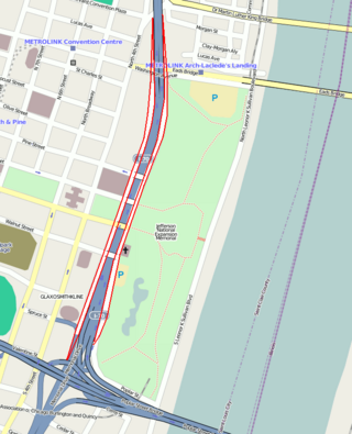
Memorial Drive runs north–south in Downtown St. Louis, Missouri. It is between the city's central business district and the grounds of the Gateway Arch and Gateway Arch National Park. It has an intimate relationship with Interstate 44 ; for most of its length, it runs above the sunken highway, but north of Washington Avenue it goes under it as the highway ramps up above the city.

MetroBus is a public bus service operated by Metro Transit that serves the Greater St. Louis area. In 2023, the service had an annual ridership of 12,531,400, or about 39,400 per weekday as of the fourth quarter of 2023.
The streets of St. Louis, Missouri, United States, and the surrounding area of Greater St. Louis are under the jurisdiction of the City of St. Louis Street Department. According to the department's Streets Division, there are 1,000 miles (1,600 km) of streets and 600 miles (970 km) of alleys within the city.

Dierbergs is a supermarket chain based in Chesterfield, Missouri. It effectively splits the Greater St. Louis grocery market with Schnucks among locally-based retailers. Dierbergs operates 26 stores in both Missouri and Illinois. In 2006 it employed more than 5,000 employees, making it one of the top 25 largest employers in the St. Louis metro area.
The history of St. Louis, Missouri, from 1905 to 1980 saw declines in population and economic basis, particularly after World War II. Although St. Louis made civic improvements in the 1920s and enacted pollution controls in the 1930s, suburban growth accelerated and the city population fell dramatically from the 1950s to the 1980s. Like many urban areas, St. Louis experienced high unemployment during the Great Depression, then expanded its industrial base during World War II. The city became home to Gateway Arch National Park during the 1930s, and during the 1960s the Gateway Arch was built on the memorial grounds. St. Louis City and St. Louis County made multiple attempts at consolidation during the period, but none were particularly successful. Despite attempts at urban renewal that included public housing projects such as the Pruitt-Igoe complex, the city continued to lose population to county cities.
Parks in Greater St. Louis are administered by a variety of state, county, and municipal authorities. The region also is home to Gateway Arch National Park, site of the Gateway Arch, the only National Memorial in the state of Missouri. Among the largest municipal parks is Forest Park, which is 1,293 acres (5.2 km2) and is located in the city of St. Louis, although both Greensfelder County Park and Creve Coeur Park in St. Louis County are larger, at 1,646 and 2,114 acres respectively. St. Louis County is also the location of two large state parks, Babler State Park with 3.8 square miles (9.8 km2) and Castlewood State Park with 2.8 square miles (7.3 km2). The largest state park in the region is Meramec State Park, located near Sullivan, Missouri, with 10.8 square miles (28 km2) of parkland.
Kiener Plaza is a public park in downtown St. Louis, Missouri. The park is part of the Gateway Mall and is bounded by Chestnut and Market streets on the north and south and Broadway and 7th Street on the east and west.

The Green Line is a planned expansion of the MetroLink light rail system in St. Louis, Missouri. The north/south running line will be at-grade street running with a dedicated lane and will be the system's third line.


