
Tyler Park is a neighborhood three miles (5 km) southeast of downtown Louisville, Kentucky, USA. It is considered a part of a larger area of Louisville called The Highlands. Near the middle of the neighborhood is a city park of the same name, and many houses in the neighborhood feature park views. The neighborhood boundaries are St Louis Cemetery to the north, Bardstown Road to the east, Eastern Parkway to the south and Beargrass Creek to the west.
The St. Louis Stars, originally the St. Louis Giants, were a Negro league baseball team that competed independently from as early as 1906 to 1919, and then joined the Negro National League (NNL) for the duration of their existence. After the 1921 season, the Giants were sold by African-American promoter Charlie Mills to Dick Kent and Dr. Sam Sheppard, who built a new park and renamed the club the Stars. As the Stars, they eventually built one of the great dynasties in Negro league history, winning three pennants in four years from 1928 to 1931.

Benton Park West is a neighborhood located in South St. Louis City, Missouri, United States. The neighborhood is bounded by Jefferson Ave. on the east, Gravois Ave. on the north and west, and an irregular boundary consisting of Cherokee Street, S. Compton Ave., and Potomac St. to the south. The neighborhood is the conglomeration of two different neighborhoods in the 1970s, Compton Hill and Marquette-Cherokee. Parts of these two 1970s neighborhoods make up the current day Benton Park West. Marquette-Cherokee was bounded by Arsenal Street on the north, Bates Street on the south and Grand Boulevard on the west. Its eastern edge was the bank of the Mississippi River. Benton Park West has the highest percentage of Latino residents among St. Louis neighborhoods.

Clifton Heights is a neighborhood of St. Louis, Missouri, US, located along the southwest border of the city and highlighted by a park — Clifton Park (38.6143°N 90.2916°W) — with a playground and a lake.

Benton Park is a neighborhood in southside St. Louis, Missouri, just west of the Soulard neighborhood. The official boundaries of the area are Gravois Avenue on the north, Cherokee Street on the south, I-55 on the east, and Jefferson Avenue on the west. Benton Park is unrelated to Benton Place, a private street located in Lafayette Square, St. Louis.

DeBaliviere Place is a neighborhood of St. Louis, Missouri.
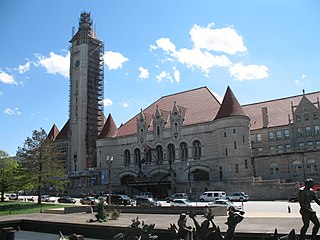
Downtown West is a neighborhood in St. Louis, Missouri. It is, as the name suggests, a section of downtown that is further inland, west from the banks of the Mississippi River. St. Louis City Hall, the Metropolitan Police Headquarters, St. Louis Union Station, Stifel Theatre, Enterprise Center, and CityPark stadium are all located in Downtown West. The Washington Avenue Historic District is a former garment district consisting of turn of the previous century high rise warehouses converted into residential lofts, restaurants, taverns, and coffee shops. It is bounded by Jefferson Avenue on the west, Tucker Boulevard on the east, Cole Street on the north, and Chouteau Avenue on the south.

Dutchtown is a neighborhood of St. Louis, Missouri. It is called "Dutch" from Deutsch, i.e., "German", as it was the southern center of German-American settlement in St. Louis in the early 19th century. It was the original site of Concordia Seminary, Concordia Publishing House, Lutheran Hospital, and other German community organizations. The German Cultural Society still has its headquarters there. St Anthony of Padua Catholic Church towers over the neighborhood and is a symbol of the neighborhood.
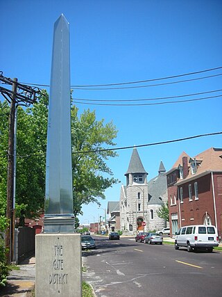
The Gate District is a neighborhood of St. Louis, Missouri. The Gate District is defined as the area between Chouteau Avenue and Interstate 44 on the north and south and between South Jefferson Avenue and South Grand Boulevard on the east and west. This area is just south of the central corridor and west of Lafayette Square. The term Gate was added to define this neighborhood due to the number of ironclad gates lining the streets. Today, the neighborhood is the subject of increased gentrification.
Gravois Park is a historic neighborhood of St. Louis, Missouri. Roughly bounded by Jefferson Avenue, Chippewa Street, Grand Boulevard, and Cherokee Street, the Gravois Park neighborhood is a diverse mix of homeowners, renters, and businesses. The area's architecture reflects its settlement at the turn of the 20th century. The namesake park dates from 1812, and was praised for its beauty in the nineteenth century already, and in 1914 was part of a walking tour of the city meant to show off the City Plan Commission's "idealized view of the shape of the city."

Hyde Park is a neighborhood of St. Louis, Missouri. A historic North St. Louis neighborhood, Hyde Park is bound by Ferry to the North, I-70 to the East, Palm Street and Natural Bridge Avenue to the South, and Glasgow to the West.

St. Louis Hills is a neighborhood in St. Louis, Missouri. The neighborhood, which is home to the Chippewa location of Ted Drewes Frozen Custard, is situated in the southwest part of St. Louis. It is bounded by Chippewa Street to the northwest and north, Hampton Avenue to the east, Gravois Avenue to the southeast, and the St. Louis county border to the southwest.

Kosciusko is a mostly non-residential neighborhood located in St. Louis, Missouri. It begins at the Mississippi River front in the east and goes up to 7th Boulevard and 8th Street in the west. Interstate 55 is a northern border, and St. George and Dorcas Streets border the south of this neighborhood. Kosciusko is named in honor of Tadeusz Kościuszko, an American Revolutionary war general of Polish descent.

Mount Pleasant is a neighborhood of St. Louis, Missouri. The neighborhood's boundaries are defined by Compton Avenue on the west, the Mississippi River on the east, Meramec Street on the north, and Eichelberger Street on the south. The Mount Pleasant neighborhood is home to several landmarks, most notably St. Anthony of Padua Church and Mount Pleasant Park. Mount Pleasant Park is a major attraction to the neighborhood. It features a unique outdoor roller hockey rink in the southwest corner in addition to various standard playground equipment.

North Hampton is a neighborhood of St. Louis, Missouri. Located in Southwest City, North Hampton is bounded by Scanlan and Connecticut to the north, South Kingshighway Boulevard to the east, Chippewa Street to the south, and Hampton Avenue to the west.

O'Fallon is a neighborhood of St. Louis, Missouri. The neighborhood is located on the north side of the City of St. Louis, nestled between O'Fallon Park and Fairground Park. It is bounded by West Florissant, Harris Avenue, Algernon Street and Adelaide on the north, Pope Avenue on the northwest, Kossuth and Natural Bridge Avenues on the south via Fair Avenue, Warne on the east, and Newstead on the west. The O'Fallon neighborhood is located in the 21st Ward which is currently represented by Alderman John Collins-Muhammad.
Windsor Park is a neighborhood in the southeastern part of St. Boniface, a neighbourhood of Winnipeg, Manitoba, Canada. It is bordered by Marion Street on the north, Archibald Street on the west, Lagimodière Boulevard on the east, and Fermor Avenue on the south. Its main thoroughfares include Autumnwood Drive, Drake Boulevard, Cottonwood Road, and Maginot Street.
Union Grounds, also known as Union Base Ball Park, was a baseball grounds in St. Louis, Missouri. It was home to the St. Louis Maroons of the Union Association during the 1884 season and the Maroons entry in the National League in 1885 and 1886.

Hyde Park is a municipal park in St. Louis.

Aboussie Park is a municipal park in St. Louis. It is the city's smallest park, with less than 1-acre (4,000 m2). Aboussie Park was established in 1981.

