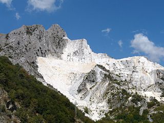
A quarry is a type of open-pit mine in which dimension stone, rock, construction aggregate, riprap, sand, gravel, or slate is excavated from the ground. The operation of quarries is regulated in some jurisdictions to reduce their environmental impact.
Quartzite is a hard, non-foliated metamorphic rock which was originally pure quartz sandstone. Sandstone is converted into quartzite through heating and pressure usually related to tectonic compression within orogenic belts. Pure quartzite is usually white to grey, though quartzites often occur in various shades of pink and red due to varying amounts of hematite. Other colors, such as yellow, green, blue and orange, are due to other minerals.

The Katy Trail State Park is a state park in the U.S. state of Missouri that contains the Katy Trail, the country's longest recreational rail trail. It runs 240 miles (390 km), largely along the northern bank of the Missouri River, in the right-of-way of the former Missouri–Kansas–Texas Railroad. Open year-round from sunrise to sunset, it serves hikers, joggers, and cyclists. Its hard, flat surface is of "limestone pug".

George L. Smith State Park is a 1,634-acre (6.61 km2) Georgia state park located in Emanuel County. The park is named after George L. Smith, a former speaker of the Georgia House of Representatives and Emanuel County native. Attractions include a grist mill, covered bridge, and the dam of the Parrish Mill. The park's location on a 412-acre (1.67 km2) mill pond dotted with many cypress trees makes it a destination for anglers and canoeists. The moderately-sized state park is in a remote location, making it an attraction for bird watchers and naturalists. Rare birds in residence include the great blue heron and the white ibis.
The Driftless Area, a region in the American Midwest, comprises southwestern Wisconsin, southeastern Minnesota, northeastern Iowa, and the extreme northwestern corner of Illinois. It was never covered by ice during the last ice age, and therefore lacks glacial deposits, also termed drift. Its landscape is characterized by steep hills, forested ridges, deeply carved river valleys, and karst geology with spring-fed waterfalls and cold-water trout streams. Ecologically, the Driftless Area's flora and fauna are more closely related to those of the Great Lakes region and New England than those of the broader Midwest and central Plains regions. The steep riverine landscape of both the Driftless Area proper and the surrounding Driftless-like region are the result of early glacial advances that forced preglacial rivers that flowed into the Great Lakes southward, causing them to carve a gorge across bedrock cuestas, thereby forming the modern incised upper Mississippi River valley. The region has elevations ranging from 603 to 1,719 feet at Blue Mound State Park, and together with the Driftless-like region, covers 24,000 square miles (62,200 km2).
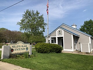
Kelleys Island State Park is a public recreation area occupying one-quarter of Kelleys Island, an island in Lake Erie located 13 miles (21 km) northeast of Port Clinton, Ohio, in the United States. The state park's 677 acres (274 ha) include six miles (9.7 km) of hiking trails, ruins of lime kilns and quarrying operations, sand beach, and campground. The park was established in 1956. The park cooperates with other agencies to manage the adjoining Glacial Grooves State Memorial, a set of rare glacial grooves, North Shore Alvar State Natural Area, a rare alvar habitat, and the North Pond State Nature Preserve, a lake embayment usually separated from the lake by a sand bar.

Cougar Mountain Regional Wildland Park is a regional park in King County, Washington, near the towns of Bellevue and Issaquah. The park was established in June 1983 to protect the central core of Cougar Mountain, the park covers 3,115 acres (12.61 km2) with 38 miles (61 km) of hiking trails and 12 miles (19 km) of equestrian trails.

Cuckmere Haven is an area of flood plains in Sussex, England where the river Cuckmere meets the English Channel between Eastbourne and Seaford. The river is an example of a meandering river, and contains several oxbow lakes. It is a popular tourist destination with an estimated 350,000 visitors per year, where they can engage in long walks, or water activities on the river. The beach at Cuckmere Haven is next to the famous chalk cliffs, the Seven Sisters.
Summit Metro Parks is a Metroparks system serving the citizens of Summit County, Ohio by managing 14,000 acres (5,700 ha) in 16 developed parks, six conservation areas and more than 150 miles (240 km) of trails, with 22.4 miles (36.0 km) of the Ohio & Erie Canal Towpath Trail.

Snow Canyon State Park is a state park in Utah, located in the Red Cliffs Desert Reserve. The park features a canyon carved from the red and white Navajo sandstone of the Red Mountains, as well as the extinct Santa Clara Volcano, lava tubes, lava flows, and sand dunes. Snow Canyon is located near the cities of Ivins and St. George in Washington County.

Bickerton Hill refers to two low red sandstone hills that form the southern end of the Mid Cheshire Ridge in Cheshire, north-west England. The high point, Raw Head, lies on the northerly hill and has an elevation of 227 metres. Parts of the southerly hill are also known as Larkton Hill.
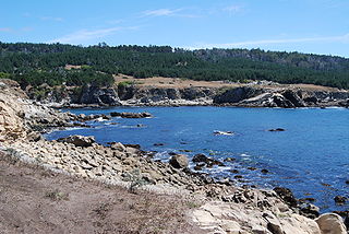
Salt Point State Park is a state park in Sonoma County, California, United States. The park covers 6,000 acres (2,428 ha) on the coast of Northern California, with 20 miles (32 km) of hiking trails and over 6 miles (9.7 km) of a rough rocky coast line including Salt Point which protrudes into the Pacific Ocean. The park also features the first underwater preserves in California. The constant impact of the waves forms the rocks into many different shapes. These rocks continue underwater providing a wide variety of habitats for marine organisms. The activities at Salt Point include hiking, camping, fishing, scuba diving and many others. The weather is cool with fog and cold winds, even during the summer.
Buffalo Rock State Park & Effigy Tumuli is an Illinois state park on 298 acres (121 ha) in LaSalle County, Illinois, United States. The park sits across the Illinois River from Starved Rock State Park, just south of the Illinois and Michigan Canal trail. According to legend, it was once used as a "blind canyon" for Indians to capture buffalo. Effigy Tumuli, an art exhibit on the park property, consists of five earth art animal sculptures native to the Illinois River. It was constructed as a tribute to Native American tradition. The park is located 5 miles (8.0 km) east of Utica, Illinois, and approximately 85 miles (137 km) southwest of Chicago, Illinois. Its sandstone bluffs were carved by the Illinois River near the end of the Pleistocene epoch, and now serves as a State Park for local residents and tourists.

St. Vrain State Park, formerly known as Barbour Ponds is a Colorado state park. The park hosts year-round camping. It is a popular birding destination, hosting the states largest rookery of Blue Heron, it is home to several other bird species as well including migrating waterfowl, songbirds and the occasional bald eagle. Other park activities include year round fishing and hiking. There are plans for a reservoir to be built at the park named Blue Heron Reservoir.

The Chatsworth Nature Preserve (CNP) is a 1,325-acre (536 ha) open-space preserve located in the northwest corner of the San Fernando Valley in Los Angeles, California, United States. The preserve contains oak woodlands, savanna, riparian areas, grassland, vernal pools, and an Ecology Pond, all of which support more than 200 bird species and numerous mammals, amphibians and reptiles.

Penistone Hill Country Park is an open space of moorland that is located to 0.31 miles (0.5 km) west of Haworth and 0.62 miles (1 km) north-west of Oxenhope in West Yorkshire, England. The park's highest point is detailed with a trig point which is 1,030 feet (310 m) above sea level. Since 1994, the park has been notified as being an SSSI as part of the South Pennine Moors.
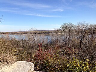
Cliff Cave County Park is a 525-acre public park located in St. Louis, Missouri. The park is operated by St. Louis County Parks. It is named after Cliff Cave, a natural cave located in the park that is a historical and archaeologic site. The park contains woodlands, wetlands, and rocky hillsides and is adjacent to the Mississippi River. It has three trails: the Mississippi Trail, the Spring Valley Trail, and the River Bluff Trail. The Riverside Shelter overlooks the Mississippi River. An active train track runs through the park. Cliff Cave Park is part of the Mississippi River Greenway. The park won the "Best View of the Mississippi" award in 2009, which it was granted by The Riverfront Times.

Sugarloaf Mountain near the town of Patrick is an unusual hill, known locally as "The Mountain," that towers a hundred feet above the surrounding terrain. This site is located within the Sand Hills State Forest, just off US highway 1, near Patrick, South Carolina in the Carolina Sandhills region of the U.S. Atlantic Coastal Plain province.
Indian Camp Creek Park is a public park in Foristell, Missouri. It is located in the northwestern part of St. Charles County and is operated by the St. Charles County Parks Department. It is the county's largest park at 603 acres.
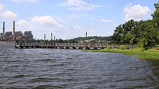
Martin Creek Lake State Park is a 286 acres (116 ha) developed recreational area in East Texas in the United States. The park is located southwest of Tatum on Martin Creek Lake in Rusk County and is managed by the Texas Parks and Wildlife Department. The Texas Utilities Generating Company deeded the park to the state in 1976, and it opened the same year.


