Musquash Parish, New Brunswick

Last updated

Musquash
Saint John County NB - Musquash Parish.png
Location within Saint John County.
map erroneously shows Saint John as part of Simonds Parish
Coordinates: 46°10′N66°22′W / 46.17°N 66.36°W / 46.17; -66.36
Country Flag of Canada (Pantone).svg  Canada
Province Flag of New Brunswick.svg  New Brunswick
County Saint John County
Erected1877
Area
[1]
  Land233.06 km2 (89.98 sq mi)
Population
 (2021) [1]
  Total1,253
  Density5.4/km2 (14/sq mi)
  Change 2016-2021
Increase2.svg 4.9%
  Dwellings
594
Time zone UTC-4 (AST)
  Summer (DST) UTC-3 (ADT)
Median Income*$71,680 CDN
  • Median household total income, 2015 (all households)

Musquash is a geographic parish in Saint John County, New Brunswick, Canada. [4]

Contents

For governance purposes, the parish is part of the incorporated rural community of Fundy Shores, [5] which is a member of the Southwest Regional Service Commission. [6]

Prior to the 2023 governance reform, the parish formed the local service district of the parish of Musquash, [7] which was a member of the Fundy Regional Service Commission (FRSC). [8]

Origin of name

The Provincial Archives of New Brunswick gives it origin as "derived from the Maliseet word for muskrat" but does not mention that word or give a source. [9]

William F. Ganong has entries for Musquash Islands and Musquash Harbour, the former translated from the French I. aux Rats musquez, island of muskrats, the latter uncertain, both possibly related to Maliseet words. [10]

Musquash is a synonym of muskrat, possibly borrowed from Massachusett. [11]

History

Musquash was erected in 1877 from Lancaster Parish. [12]

Boundaries

Musquash Parish is bounded: [2] [13] [14]

Communities

Communities at least partly within the parish. [13] [14] [15]

Bodies of water

Bodies of water [lower-alpha 1] at least partly within the parish. [13] [14] [15]

Islands

Islands at least partly within the parish. [13] [14] [15]

Other notable places

Parks, historic sites, and other noteworthy places at least partly within the parish. [13] [14] [15] [16]

Demographics

Access Routes

Highways and numbered routes that run through the parish, including external routes that start or finish at the parish limits: [20]

See also

Notes

  1. Not including brooks, ponds or coves.

Related Research Articles

<span class="mw-page-title-main">Campobello Island</span> Island in Campobello, New Brunswick, Canada

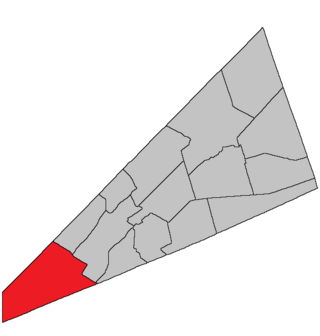
Campobello Island is the largest and only inhabited island in Campobello, a geographic parish in southwestern New Brunswick, Canada, near the border with Maine, United States. The island's permanent population in 2021 was 949. It is the site of the Roosevelt Campobello International Park, Head Harbour Lighthouse, and of Herring Cove Provincial Park.

<span class="mw-page-title-main">Waterborough Parish, New Brunswick</span> Parish in New Brunswick, Canada

Waterborough is a geographic parish in Queens County, New Brunswick, Canada.

<span class="mw-page-title-main">Wicklow Parish, New Brunswick</span> Parish in New Brunswick, Canada

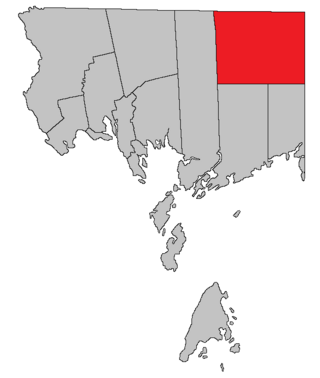
Wicklow is a geographic parish in Carleton County, New Brunswick, Canada, forming the northwestern corner of Carleton County.

<span class="mw-page-title-main">McAdam Parish, New Brunswick</span> Parish in New Brunswick, Canada

McAdam is a geographic parish in York County, New Brunswick, Canada.

<span class="mw-page-title-main">Maugerville Parish, New Brunswick</span> Parish in New Brunswick, Canada

Maugerville is a geographic parish in Sunbury County, New Brunswick, Canada.

Route 790 is a 31.1-kilometre (19.3 mi) long mostly east–west secondary highway in the southwestern portion of New Brunswick, Canada.

<span class="mw-page-title-main">Hillsborough Parish, New Brunswick</span> Parish in New Brunswick, Canada

Hillsborough is a geographic parish in eastern Albert County, New Brunswick, Canada.

<span class="mw-page-title-main">Hammond Parish, New Brunswick</span> Parish in New Brunswick, Canada

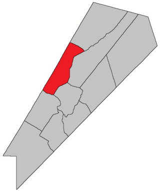
Hammond is a geographic parish in Kings County, New Brunswick, Canada.

<span class="mw-page-title-main">Saint Martins Parish, New Brunswick</span> Parish in New Brunswick, Canada

Saint Martins is a geographic parish in Saint John County, New Brunswick, Canada.

<span class="mw-page-title-main">Simonds Parish, Saint John County, New Brunswick</span> Parish in New Brunswick, Canada

Simonds is a geographic parish in Saint John County, New Brunswick, Canada.

<span class="mw-page-title-main">Westfield Parish, New Brunswick</span> Parish in New Brunswick, Canada

Westfield is a geographic parish in Kings County, New Brunswick, Canada.

<span class="mw-page-title-main">Petersville Parish, New Brunswick</span> Parish in New Brunswick, Canada

Petersville is a geographic parish in Queens County, New Brunswick, Canada.

<span class="mw-page-title-main">Lepreau Parish, New Brunswick</span> Parish in Canada

Lepreau is a geographic parish in Charlotte County, New Brunswick, Canada, west of Saint John.

<span class="mw-page-title-main">Clarendon Parish, New Brunswick</span> Parish in Canada

Clarendon is a geographic parish in Charlotte County, New Brunswick, Canada, located in the interior to the north of Point Lepreau and southwest of CFB Gagetown.

<span class="mw-page-title-main">Canning Parish, New Brunswick</span> Parish in New Brunswick, Canada

Canning is a geographic parish in Queens County, New Brunswick, Canada.

<span class="mw-page-title-main">Sheffield Parish, New Brunswick</span> Parish in New Brunswick, Canada

Sheffield is a geographic parish in Sunbury County, New Brunswick, Canada.

<span class="mw-page-title-main">Wickham Parish, New Brunswick</span> Parish in New Brunswick, Canada

Wickham is a geographic parish in Queens County, New Brunswick, Canada.

<span class="mw-page-title-main">Pennfield Parish, New Brunswick</span> Parish in Canada

Pennfield is a geographic parish in Charlotte County, New Brunswick, Canada, located west of Saint John located east of St. George and west of Saint John.

<span class="mw-page-title-main">West Isles Parish, New Brunswick</span> Parish in Canada

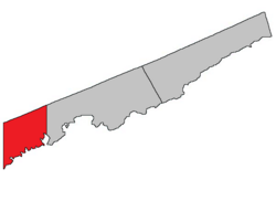
West Isles is a geographic parish in Charlotte County, New Brunswick, Canada.

<span class="mw-page-title-main">Saint George Parish, New Brunswick</span> Parish in Canada

Saint George is a geographic parish in Charlotte County, New Brunswick, Canada, located between St. Stephen and Saint John.

References

  1. 1 2 "Census Profile". Statistics Canada. 26 October 2022. Retrieved 29 October 2022.
  2. 1 2 "Chapter T-3 Territorial Division Act". Government of New Brunswick. Retrieved 16 April 2023.
  3. "Chapter I-13 Interpretation Act". Government of New Brunswick. Retrieved 16 April 2023.
  4. The Territorial Division Act [2] divides the province into 152 parishes, the cities of Saint John and Fredericton, and one town of Grand Falls. The Interpretation Act [3] clarifies that parishes include any local government within their borders.
  5. "Southwest Regional Service Commission: RSC 10". Government of New Brunswick. Retrieved 16 April 2023.
  6. "Regions Regulation – Regional Service Delivery Act". Government of New Brunswick. 21 July 2022. Retrieved 16 April 2023.
  7. "Local Service Districts Regulation - Municipalities Act". Government of New Brunswick. 25 June 2021. Retrieved 16 April 2023.
  8. "Communities in each of the 12 Regional Service Commissions (RSC) / Les communautés dans chacune des 12 Commissions de services régionaux (CSR)" (PDF), Government of New Brunswick, July 2017, retrieved 2 February 2021
  9. "Musquash Parish". Provincial Archives of New Brunswick. Retrieved 23 October 2020.
  10. Ganong, William F. (1896). A Monograph of the Place-Nomenclature of the Province of New Brunswick. Royal Society of Canada. p. 227. Retrieved 17 March 2021.
  11. "musquash". The Free Dictionary. Farlex. Retrieved 23 October 2020. American Heritage Dictionary of the English Language and Collins English Dictionary are cited.
  12. "40 Vic. c. 21 An Act to erect part of the Parish of Lancaster, in the City and County of Saint John, into a separate Parish.". Acts of the General Assembly of Her Majesty's Province of New Brunswick. Passed in the Month of March 1877. Fredericton: Government of New Brunswick. 1877. pp. 91–93. Available as a free ebook from Google Books.
  13. 1 2 3 4 5 "No. 163". Provincial Archives of New Brunswick. Department of Natural Resources and Energy Development. Retrieved 22 June 2021. Remainder of parish on map 164 at same site.
  14. 1 2 3 4 5 "482" (PDF). Transportation and Infrastructure. Government of New Brunswick. Retrieved 22 June 2021. Remainder of parish on mapbooks 483, 492, 493, and 499 at same site.
  15. 1 2 3 4 "Search the Canadian Geographical Names Database (CGNDB)". Government of Canada. Retrieved 2 July 2021.
  16. "Explore New Brunswick's Protected Natural Areas". GeoNB. Retrieved 2 July 2021.
  17. Statistics Canada: 2001, 2006 census
  18. 2011 Statistics Canada Census Profile: Musquash Parish, New Brunswick
  19. 1 2 "Census Profile, 2016 Census: Musquash, Parish [Census subdivision], New Brunswick". Statistics Canada. Retrieved 29 September 2019.
  20. Atlantic Canada Back Road Atlas ISBN   978-1-55368-618-7