Neman

Last updated
Neman
Niemen
Nemunas
Neman river.jpg
The Neman near Alytus
Nemunas-en.png
Map highlighting Neman
Etymologypossible Slavic word for monster
Location
Country Belarus, Lithuania, Russia
Cities Stowbtsy, Grodno, Druskininkai, Alytus, Birštonas, Prienai, Kaunas, Jurbarkas, Sovetsk
Physical characteristics
Source 
  locationSouthwest of Minsk, Belarus
  coordinates 53°15′10″N27°18′21″E / 53.25278°N 27.30583°E / 53.25278; 27.30583
  elevation176 m (577 ft)
Mouth Curonian Lagoon
  location
West of Šilutė, Lithuania
  coordinates
55°20′12″N21°14′50″E / 55.33667°N 21.24722°E / 55.33667; 21.24722
  elevation
0 m (0 ft)
Length937 km (582 mi)
Basin size98,200 km2 (37,900 sq mi)
Discharge 
  location Curonian Lagoon, linked to the Baltic Sea
  average678 m3/s (23,900 cu ft/s) [1]

The Neman,Niemen or Nemunas [nb 1] is a river in Europe that rises in central Belarus and flows through Lithuania then forms the northern border of Kaliningrad Oblast, Russia's western exclave, which specifically follows its southern channel. It drains into the Curonian Lagoon, narrowly connected to the Baltic Sea. The 937 km (582 mi) long Neman is a major Eastern European river. It flows generally west to Grodno within 12 kilometres (7.5 mi) of the Polish border, north to Kaunas, then westward again to the sea.

Contents

The largest river in Lithuania, and the third-largest in Belarus, it is navigable for most of its length. It starts from two small headwaters merging about 15 kilometers (9 mi) southwest of the town of Uzda about 55 km (34 mi) southwest of capital city Minsk. Only 17 kilometres (11 mi), an eastward meander, contributes to the Belarus–Lithuania border. Thereafter the river includes notable loops along a minor tectonic fault.

Its drainage basin settled in the late Quaternary to be roughly along the edge of the last glacial sheet so dates to about 25,000 to 22,000 years BC. Its depth varies from 1 meter (3 ft 3 in) in its upper courses to 5 meters (16 ft) in the lower basin.

Numbers

The Neman near Grodno BelNeman river.jpg
The Neman near Grodno
Neman opposite Kaliningrad Oblast (Russian exclave) Memel R..JPG
Neman opposite Kaliningrad Oblast (Russian exclave)

River course

Nemunas loops

Nemunas bend in Liskiava Liskiava Neman.jpg
Nemunas bend in Liškiava
500 litas banknote featuring Nemunas loops Nemunas loops - 500 litai.jpg
500 litas banknote featuring Nemunas loops

Due to their location, "The Nemunas loops" are often described using the Lithuanian name for the river. In 1992 Nemunas Loops Regional Park was founded. Its goal is to preserve the loops (Lithuanian: vingis) that the river makes in the Punia forest. Near Prienai, the Nemunas makes a 17-kilometer-long (11 mi) loop (like a teardrop) coming within 1.2 km (34 mi) of completing the loop. The Nemunas flows along the double bend between Balbieriškis and Birštonas for 48 km (30 mi) and then moves in a northerly direction for only 4.5 km (2+34 mi). The loops are not conventional river meanders; they follow underlying tectonic structures. The faults are the source of local mineral springs. [5] The area is historically and culturally significant. Its castles served as the first line of defense against forays by the Teutonic knights.

Delta

At its delta the Nemunas splits into a maze of river branches and canals mixing with polders and wetlands and is a very attractive destination for eco-tourism. The four main distributaries are Atmata, Pakalnė, Skirvytė (the southern mouth, marking the international border) and Gilija. The river plays a crucial part in the ecosystem of the Curonian Lagoon. It provides the main water inflow to the lagoon and keeps the water almost fresh. This allows fresh water and brackish water animals to survive there. As the delta extends north the lagoon opposite narrows. Since the delta is in Lithuania, it is often referred to as Nemunas Delta. Nemunas Delta Regional Park was created in the delta in 1992.

Tributaries

The following rivers are tributaries to the river Neman/Nemunas (from source to mouth):

Largest settlements on the river

From west to east, the largest settlements are Sovetsk/Tilsit, Neman, Kaunas, Alytus, Druskininkai, Grodno, and Masty.

Significance in culture

Ptolemy referred to Neman as Chronos (although competing theories suppose Chronos was in fact Pregolya).

The river has lent its name to the Neman Culture, a Neolithic archaeological subculture. [6]

Napoleon and his army crossing the Neman in June 1812 Crossing the Neman in Russia 1812 by Clark.jpg
Napoleon and his army crossing the Neman in June 1812

In German, the part of the river flowing through historic Prussia has been called die Memel at least since about 1250, when Teutonic Knights built Memelburg castle and the town of Memel at the mouth of the Curonian Lagoon, naming it after the indigenous name of the river, Memel. The city of Memel, now in Lithuania, is known today as Klaipėda (confusingly, another city of Memel was on the Dange River, now called the Danė). In German road maps and lexika, only the 112-kilometer (70 mi) section within Prussia (starting at Schmalleningken) was named Memel; the bulk of the river was the Niemen.

The border between the State of the Teutonic Order and Lithuania was fixed in 1422 by the Treaty of Lake Melno and remained stable for centuries. The Treaty of Tilsit between Napoleon and Tsar Alexander I was signed on a raft in the river in 1807. [7] Napoleon's crossing at the outset of the 1812 French invasion of Russia is described in War and Peace [8] and also mentioned in Pan Tadeusz . In 1919, the Treaty of Versailles made the river the border separating the Memel Territory from German East Prussia as of 1920. At that time, Germany's Weimar Republic adopted the Deutschlandlied as its official national anthem. In the first stanza of the song, written in 1841, the river is mentioned as the eastern border of a (then politically yet-to-be united) Germany:

The Nemunas in Druskininkai Druskininkai Neman.jpg
The Nemunas in Druskininkai
German lyricsApproximate English translation
Von der Maas bis an die Memel,
Von der Etsch bis an den Belt
From the Meuse to the Memel,
From the Adige to the Belt

Lithuanians refer to the Nemunas as "the father of rivers" (Nemunas is a masculine noun in Lithuania). Countless companies and organizations in Lithuania have "Nemunas" in their name, including a folklore ensemble, a weekly magazine about art and culture, a sanatorium, and numerous guest houses and hotels. Lithuanian and Polish literature often mention the Nemunas. One of the most famous poems by Maironis starts:

Lithuanian lyricsApproximate English translation
Kur bėga Šešupė, kur Nemunas tekaWhere the Šešupė runs, where the Nemunas flows
Tai mūsų tėvynė, graži LietuvaThat's our fatherland, beautiful Lithuania

Almost every Lithuanian can recite these words by heart.

Smaller rivers and rivulets in Lithuania with names morphologically derived or cognate are the Nemunykštis, Nemuniukas, Nemunynas, Nemunėlis and Nemunaitis.

The etymology is disputed: some say that "Nemunas" is an old word meaning "a damp place", [9] while others that it is "mute, soundless river" (from nemti, nėmti "to become silent", also memelis, mimelis, mėmė "slow, worthless person"). [10] The name is possibly derived from the Finnic word niemi "cape". [11]

Art critics praised its depiction in the paintings by Michał Kulesza. [12] [13]

Economic significance

Schematic map of Kaunas Reservoir area Kaunas Lagoon.png
Schematic map of Kaunas Reservoir area

Much of the river is used for fishing, hydropower generation, water supply, industry, agriculture, recreation, tourism, and water transport.

Lithuania has tabled local plans to dredge it, below Kaunas, to make it more consistently usable. [14]

The largest cities on the river are Grodno in Belarus, Alytus and Kaunas in Lithuania, and Sovetsk in the Kaliningrad Oblast of Russia. The river basin has a population of 5.4 million inhabitants. Industrial activities in the Belarusian section include metal processing, chemical industries, pulp and paper production, and manufacturing of building materials, as well as food-processing plants. In Lithuania, the city of Kaunas, with about 400,000 inhabitants, is the country's principal user of the river; the local industries that impact the river are hydropower generation, machinery, chemical, wood processing and paper production, furniture production, textile and food-processing. In Kaliningrad, industrial centers near the river include Sovetsk and Neman, which have large pulp and paper production facilities.

Above Kaunas a dam was built in 1959 to serve the Kaunas Hydroelectric Power Plant. The resulting Kaunas Reservoir (Lithuanian : Kauno marios) is the largest such lake in Lithuania. It occupies 63.5 km2 (24+12 sq mi); its length is 93 km (58 mi); its greatest depth is 22 m (72 ft). The reservoir is a popular destination for Lithuanian yachting.

The Augustów Canal, built in the 19th century, connects the Neman to the Vistula River.

Biological communities

Fish found include the: perch, pike, zander, roach, tench, bream, rudd, ruffe, and bleak.

Its tributaries have borne stone loach, three-spined stickleback, minnows, trout, sculpins, gudgeon, dace and chub.

Atlantic salmon migrated upstream to spawn; however, dams on the river, most of them built in the 20th century, have depleted them. The dam at Kaunas does not provide fish ladders. The spawning season took place in the fall. Ethnographic studies, from before the dams, state night fishing, using torches and harpoons, was a common technique.

Environmental issues

Neman sunset WIKINEMAnBeSunSet.jpg
Neman sunset

A report by the Swedish EPA (Environmental Protection Administration) rates the river's quality in Lithuania as moderately polluted to polluted. High concentrations of organic pollutants, nitrates and phosphates occur in parts of the river. Environmental issues include water quality (eutrophication and pollutants largely due to outdated technology sewage treatment works), changes in the hydrological regime, and flooding control. The environmental problems in each of the countries that make up the basin are slightly different. In Belarus, the main problems are oil products as well as nitrogen and BOD (biological oxygen demand). The environmental issues in the Kaliningrad section include high concentrations of BOD, lignosulphates, and nitrogen. In Lithuania, the Kaunas Hydroelectric Power Plant barrage affects the riparian ecosystem. [15]

Co-operation which would be beneficial is complicated by the geographical split between three nations but water quality improvement initiatives are underway.

See also

Notes

Related Research Articles

<span class="mw-page-title-main">Geography of Lithuania</span>

Lithuania is a country in the Baltic region of Europe. The most populous of the Baltic states, Lithuania has 262 km (163 mi) of coastline consisting of the continental coast and the "Curonian Spit" coast. Lithuania's major warm-water port of Klaipėda lies at the narrow mouth of Curonian Lagoon, a shallow lagoon extending south to Kaliningrad and separated from the Baltic sea by Curonian Spit, where Kuršių Nerija National Park was established for its remarkable sand dunes.

Transport in Lithuania relies mainly on road and rail networks.

<span class="mw-page-title-main">Neris</span> River in Lithuania and Belarus

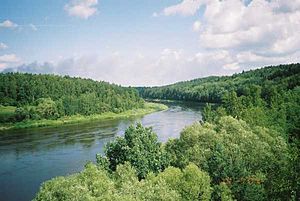
The river Neris or Vilija rises in northern Belarus. It flows westward, passing through Vilnius and in the south-centre of that country it flows into the Nemunas (Neman) from the right bank, at Kaunas, as its main tributary. Its length is 510 km (320 mi).

<span class="mw-page-title-main">Gdańsk Bay</span> Bay in the Baltic Sea adjoining the port of Gdańsk and stretching to Kaliningrad

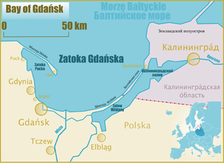
Gdańsk Bay or the Gulf of Gdańsk is a southeastern bay of the Baltic Sea. It is named after the adjacent port city of Gdańsk in Poland.

<span class="mw-page-title-main">Curonian Spit</span> Sand dune spit on the Baltic

The Curonian (Courish) Spit is a 98-kilometre (61 mi) long, thin, curved sand-dune spit that separates the Curonian Lagoon from the Baltic Sea. It is a UNESCO World Heritage Site shared by Lithuania and Russia. Its southern portion lies within Kaliningrad Oblast of Russia, and its northern within southwestern Klaipėda County of Lithuania.

<span class="mw-page-title-main">Lithuania Minor</span> Lithuanian ethnographic region in former Prussia

Lithuania Minor, or Prussian Lithuania, is a historical ethnographic region of Prussia, where Prussian Lithuanians lived, now located in Lithuania and the Kaliningrad Oblast of Russia. Lithuania Minor encompassed the northeastern part of the region and got its name from the territory's substantial Lithuanian-speaking population. Prior to the invasion of the Teutonic Knights in the 13th century, the main part of the territory later known as Lithuania Minor was inhabited by the tribes of Skalvians and Nadruvians. The land depopulated during the incessant war between Lithuania and the Teutonic Order. The war ended with the Treaty of Melno and the land was repopulated by Lithuanian newcomers, returning refugees, and the remaining indigenous Baltic peoples; the term Lithuania Minor appeared for the first time between 1517 and 1526.

<span class="mw-page-title-main">Neman, Russia</span> Town in Kaliningrad Oblast, Russia

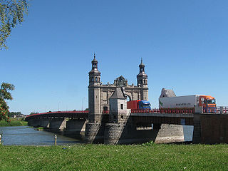
Neman, is a town and the administrative center of Nemansky District in Kaliningrad Oblast, Russia, located in the historic region of Lithuania Minor, on the steep southern bank of the Neman River, where it forms the Russian border with the Klaipėda Region in Lithuania, and 130 kilometers (81 mi) northeast of Kaliningrad, the administrative center of the oblast. Population figures: 11,798 (2010 Russian census); 12,714 (2002 Census); 13,821 (1989 Soviet census).

<span class="mw-page-title-main">Nevėžis</span> River in Lithuania

The Nevėžis is the sixth longest river in Lithuania and one of the main tributaries of the Nemunas. The 209 km (130 mi) long Nevėžis flows entirely within Lithuania. Among the rivers that flow exclusively within Lithuania's borders, the Nevėžis is the second longest, after the Šventoji. Its source is in the Anykščiai District Municipality. The river first flows in a northwesterly direction, but at Panevėžys it turns southwest, and passing Kėdainiai, flows into the Neman just west of Kaunas near Raudondvaris.

Scalovia or Skalvia was the area of Prussia originally inhabited by the now extinct Baltic tribe of Skalvians or Scalovians which according to the Chronicon terrae Prussiae of Peter of Dusburg lived to the south of the Curonians, by the lower Nemunas river, in the times around 1240.

<span class="mw-page-title-main">Nemunėlis</span> River in Lithuania and Latvia

Nemunėlis is a river in northern Lithuania and southern Latvia. It originates 6 km south of Rokiškis. It is 191 kilometres long before its confluence with the Mūša, near Bauska, forming the Lielupe.

<span class="mw-page-title-main">Panemunė</span> City in Lithuania Minor, Lithuania

Panemunė is the smallest settlement with city status in Lithuania. It is situated on the banks of the Nemunas River opposite Sovetsk, 8 km (5.0 mi) south from Pagėgiai, in Tauragė County. It is a border checkpoint for traffic to and from Russia.

<span class="mw-page-title-main">Nemunas Delta</span> River delta in Lithuania

Nemunas Delta is the Lithuanian name for the Neman (Nemunas) River Delta, in Lithuania. Prior to post-World War II border changes, it was known in German as the Memel Niederung, as the Neman was for centuries called the Memel in German.

<span class="mw-page-title-main">Merkys</span> River in Lithuania and Belarus

The Merkys is a river in southern Lithuania and northern Belarus. It flows for 13 km (8 mi) through Belarus, 5 km (3 mi) along the Belarusian–Lithuanian border, and 195 km (121 mi) through Lithuania before joining the Nemunas from the right bank near Merkinė.

<span class="mw-page-title-main">Krokų Lanka</span> Marine / lagoon lake in Lithuania

Krokų Lanka is the only lake of marine origin in Lithuania and the largest lake in the Šilutė District Municipality. It is located in the Nemunas Delta Regional Park on the Baltic Sea shore near Nemunas Delta and Ventė Cape. It covers a territory of 788 ha. Aukštumala bog, covering 3018 ha and used for peat production since 1882, is located just north of the lake and Mingė village is located on the western bank. In the south a narrow strip of water connects the lake with Atmata, a branch of the Neman River.

<span class="mw-page-title-main">Curonian Lagoon</span> Freshwater lagoon separated from the Baltic Sea by the Curonian Spit

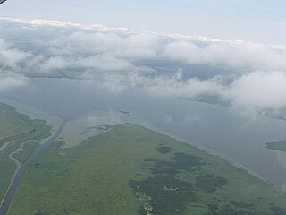
The Curonian Lagoon is a freshwater lagoon separated from the Baltic Sea by the Curonian Spit. Its surface area is 1,619 square kilometers (625 sq mi). The Neman River supplies about 90% of its inflows; its watershed consists of about 100,450 square kilometres in Lithuania and Russia's Kaliningrad Oblast.

<span class="mw-page-title-main">Lithuania–Russia border</span> International border

The Lithuania–Russia border is an international border between the Republic of Lithuania and Kaliningrad Oblast, an exclave of the Russian Federation. It is an external border of the European Union. The 274.9 km (170.8 mi) long border passes through the Curonian Spit and Curonian Lagoon, and then follows along the Neman River, Šešupė, Širvinta, Liepona, and Lake Vištytis. The sea border is another 22.2 km (13.8 mi). There is a tripoint between Lithuania, Russia, and Poland with a stone monument at 54°21′48″N22°47′31″E.

<span class="mw-page-title-main">Rusnė Island</span> Lithuanias largest island

Rusnė Island is an island in Nemunas Delta, Šilutė District Municipality, Lithuania. It is located between Atmata and Skirvytė, distributaries of the Neman River, and the Curonian Lagoon. At 45 or 46 square kilometers, Rusnė is often considered Lithuania's largest island.

<span class="mw-page-title-main">Verknė</span> 77km stream in Lithuania

The Verknė is a 77-kilometre (48 mi) stream in Lithuania. It is a right tributary of the river Neman (Nemunas); their confluence is 3 km (1.9 mi) north of Birštonas.

References

  1. https://www.worldatlas.com/seas/baltic-sea.html
  2. 1 2 3 4 "Main Geographic Characteristics of the Republic of Belarus. Main characteristics of the largest rivers of Belarus". Land of Ancestors. Data of the Ministry of Natural Resources and Environmental Protection of the Republic of Belarus. 2011. Archived from the original on 15 January 2014. Retrieved 27 September 2013.
  3. Floods and fires in Lithuania
  4. "Main Geographic Characteristics of the Republic of Belarus". Land of Ancestors. The Scientific and Production State Republican Unitary Enterprise "National Cadastre Agency" of the State Property Committee of the Republic of Belarus. 2011. Archived from the original on 21 September 2013. Retrieved 20 September 2013.
  5. "The Great Nemunas Loops". Nemunas Loops Regional Park. Archived from the original on February 26, 2008. Retrieved 2009-01-10.
  6. Rimantienė, Rimutė (March 1992). "The Neolithic of the eastern Baltic". Journal of World Prehistory. 6. Springer Netherlands: 97–143. doi:10.1007/BF00997586. S2CID   162896841.
  7. McLynn, Frank (1998). Napoleon: A Biography. Pimlico.[ page needed ]
  8. Leo Tolstoy (1915). War and Peace. J.M. Dent. p.  200. niemen river war and peace.
  9. Aleksandras Vanagas. Lietuvių hidronimų etimologinis žodynas. 227 psl., – Vilnius: Mokslas, 1981.
  10. Petronytė, Jurga (2016-08-02). "Mėmelis ar Klaipėda?". Vakarų ekspresas . Archived from the original on 2016-08-04.
  11. Tadeusz Lehr-Spławiński. O pochodzeniu i praojczyźnie Słowian. – Poznań, 1946.
  12. Kraszewski, Józef Ignacy (1847). "Pejzaż, Michał Kulesza". Tygodnik Petersburski. 18.
  13. Gr..., M...; [Michał Grabowski, pseud. of Edward Tarsza] (1849). "5". Projekta Artystyczne w Litwie. Warsaw: S. Orgelbrand.{{cite book}}: |work= ignored (help)
  14. "Transportation initiatives in the Baltic states". Archived from the original on 2006-09-25. Retrieved 2006-12-02.
  15. Report on the Neman basin issued by the Swedish EPA Archived February 18, 2006, at the Wayback Machine