
Franklin County is a county in the U.S. state of Ohio. As of the 2020 census, the population was 1,323,807, making it the most populous county in Ohio. Most of its land area is taken up by its county seat, Columbus, the state capital and most populous city in Ohio. The county was established on April 30, 1803, less than two months after Ohio became a state, and was named after Benjamin Franklin. Originally, Franklin County extended north to Lake Erie before it was subdivided into smaller counties. Franklin County is the central county of the Columbus, Ohio Metropolitan Statistical Area.
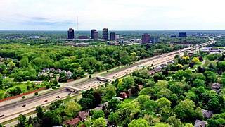
Oakland County is a county in the U.S. state of Michigan. It is a principal county of the Detroit metropolitan area, containing the bulk of Detroit's northern suburbs. Due to the county's government complex spanning 2 municipalities, its county seat is shared between Pontiac and Waterford. Its largest city is Troy. As of the 2020 Census, its population was 1,274,395, making it the second-most populous county in Michigan, and the largest county in the United States without a city of 100,000 residents.

Oakland is a borough in Bergen County, in the U.S. state of New Jersey and a suburb of New York City. As of the 2020 United States census, the borough's population was 12,748, a decrease of six people from the 2010 census count of 12,754, which in turn reflected an increase of 288 (+2.3%) from the 12,466 counted in the 2000 census.

Route 208 is an expressway in the northern part of New Jersey in the United States. It runs 10.07 miles (16.21 km) from an interchange with Route 4 and County Route 79 in Fair Lawn northwest to an interchange with Interstate 287 (I-287) in Oakland. The route runs through suburban areas of Bergen and Passaic counties as a four- to six-lane divided highway. It is an expressway, as intersections with cross roads are controlled by interchanges, but is not a freeway as several driveways exist. The route runs through the communities of Fair Lawn, Glen Rock, Hawthorne, Wyckoff, and Franklin Lakes along the way, interchanging with CR 507 in Fair Lawn and CR 502 in Franklin Lakes.
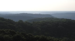
Southern Indiana is a geographic and cultural region that generally comprises the southern third of the U.S. state of Indiana and borders the states of Illinois to the west, Kentucky to the south, and Ohio to the east. Spanning the state's southernmost 33 counties, its main population centers include Southwestern Indiana, the Louisville metropolitan area (south), and the Cincinnati metropolitan area (southeast). The region's history and geography have led to a blending of Northern and Southern cultures, distinct from the rest of the state. It is often considered to be part of the Upland South and lower Midwest.

State Route 315, known locally as the Olentangy Freeway, running almost parallel to Olentangy River Road for most of its length, is a north–south highway in central Ohio, in the Columbus metropolitan area. It may be seen abbreviated as SR 315, OH-315, or simply 315. Its southern terminus is at the south junction of I-70 and I-71 in Columbus, and its northern terminus is at US 23 near Delaware. It is a controlled access freeway from its southern terminus to I-270. The controlled access section carries two or three lanes in each direction, depending on the location. North of I-270, it becomes a two-lane road. It roughly follows the Olentangy River for about two-thirds of its length. The route passes through Ohio State University campus. The section between Interstate 670 and Interstate 70 is known as the West Innerbelt, and it is commonly referred to as such in traffic reports. The original name of this section was Sandusky Street.
The Franklin Lakes Public Schools are a community public school district serving students in pre-kindergarten through eighth grade from Franklin Lakes, in Bergen County, in the U.S. state of New Jersey.

Blacklick is a small unincorporated community in southern Jefferson Township, Franklin County, Ohio, United States. Blacklick is also included in the Columbus Metropolitan area.
Riverbend is a neighborhood in southwest Columbus, Ohio. Riverbend itself is a single subdivision that is located next to Big Run Park. Because Riverbend is at the southwest border of the city, it was not annexed into the city until the late 1960s. A major road that serves as the northern boundary of the neighborhood, Clime Road, has segments that have yet to be annexed into the city.

Columbus City Schools, formerly known as Columbus Public Schools, is the official school district for the city of Columbus, Ohio, and serves most of the city. The district has 46,686 students enrolled, making it the largest school district in the state of Ohio as of June 2021. At its peak during the 1971 school year the district served 110,725 students.
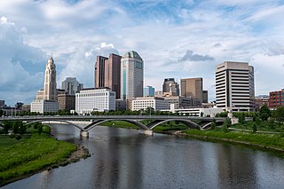
The Columbus, Ohio metropolitan area is a metropolitan area in Central Ohio surrounding the state capital of Columbus. As defined by the U.S. Census Bureau, it includes the counties of Delaware, Fairfield, Franklin, Hocking, Licking, Madison, Morrow, Perry, Pickaway, and Union. At the 2020 census, the MSA had a population of 2,138,926, making it 32nd-most populous in the United States and the second largest in Ohio, behind the Cincinnati metropolitan area. The metro area, also known as Central Ohio or Greater Columbus, is one of the largest and fastest-growing metropolitan areas in the Midwestern United States.

State Route 161 is an east–west state highway in central Ohio. Its western terminus is in Mutual at State Route 29 and its eastern terminus is near Alexandria at State Route 37. It is 57.46 miles (92.47 km) long. State Route 161 passes through the northern parts of Columbus, Ohio's state capital, and a variety of towns including Plain City, Dublin, and New Albany.
Michigan's 18th congressional district is an obsolete United States congressional district in Michigan. The first Representative to Congress elected from the 18th district, George Anthony Dondero, took office in 1953, after reapportionment due to the 1950 census. In 1933, Dondero had previously been the first representative elected from 17th district.

Elections in Ohio are held on a county, state, and federal level. The Republicans are strongest in the rural Northwest, the affluent Cincinnati and Columbus suburbs, and have made gains in Appalachian Southeast Ohio and the industrial, working-class Northeast in the 21st century. The Democrats rely on the state's major cities, and have made gains in educated suburban areas in recent years.
The Whitewater Valley Conference was an IHSAA-sanctioned conference based in Fayette, Franklin, Union, and later Henry and Wayne counties in East Central Indiana. The conference was founded in 1940 as a merger of the Franklin County Conference and Union County Conference, though because two of the FCC schools were not able to play a full conference schedule in the 1940-41 school year, two Fayette County Conference schools were added. The conference's last season was in 1967-68, as the consolidation wave of the 1950s and 1960s would leave the conference with three schools and no suitable replacements in the area, as Lewisville and Straughn became part of Tri in 1968. College Corner, whose location on the border of Indiana and Ohio allowed them to play in both the WVC and the Preble County League in Ohio, would continue to play in the PCL until joining with Short in Liberty to form Union County High School in 1974. Whitewater Township would merge into Brookville that same year. Laurel struggled on as an independent for two decades, as they were too far from the two conferences in the general region that featured schools of a similar size and sports offering, the Mid-Hoosier and Ohio River Valley conferences. The school eventually consolidated with Brookville to form Franklin County High School in 1989.
Northwest Columbus is a region in Franklin County, Ohio. It has about 45,000 residents, according to the 2010 U.S. census.
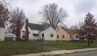
Briggsdale is a neighborhood of Franklin County in the city of Columbus, Ohio. The neighborhood is on the west/southwest side of the city within the Hilltop area. The area was first settled and founded by the family of Joseph M. Briggs, after whom the neighborhood was named. Joseph Briggs was an active figure in the early years of the township and county operations. The Briggsdale Methodist church was founded with his help, and it now exists as the New Horizons Methodist Church. The present-day Briggsdale neighborhood is located near the historical Green Lawn Cemetery to the north as well as Briggs High School to the west.
Oakland is an unincorporated community in Liberty Township, Jackson County, Ohio, United States. It is located northwest of Jackson at the intersection of Valley Chapel Road and Oakland Road, at 39°05′03″N82°42′47″W.
Oakland, Ohio may refer to any of several locations in the United States state of Ohio:

