Ohio State Route 287

Last updated

OH-287.svg

State Route 287
OH 287 map.svg
Route information
Maintained by ODOT
Length 13.69 mi [1] (22.03 km)
Existed 1931 [2] [3] – present
Major junctions
West endOH-245.svg SR 245 near West Liberty
East endUS 33.svgOH-739.svg US 33 / SR 739 near North Lewisburg
Location
Counties Logan, Union
Highway system
OH-286.svg SR 286 SR 288 OH-288.svg

State Route 287 (SR 287) is a 13.69-mile-long (22.03 km) eastwest state highway in the western portion of the U.S. state of Ohio. The western terminus of SR 287 is at SR 245 nearly 1.75 miles (2.82 km) east of West Liberty. Its eastern terminus is at an interchange with U.S. Route 33 (US 33) about 5.25 miles (8.45 km) northeast of North Lewisburg that dually serves as the southern terminus of SR 739.

A state highway, state road, or state route is usually a road that is either numbered or maintained by a sub-national state or province. A road numbered by a state or province falls below numbered national highways in the hierarchy. Roads maintained by a state or province include both nationally numbered highways and un-numbered state highways. Depending on the state, "state highway" may be used for one meaning and "state road" or "state route" for the other.

U.S. state constituent political entity of the United States

In the United States, a state is a constituent political entity, of which there are currently 50. Bound together in a political union, each state holds governmental jurisdiction over a separate and defined geographic territory and shares its sovereignty with the federal government. Due to this shared sovereignty, Americans are citizens both of the federal republic and of the state in which they reside. State citizenship and residency are flexible, and no government approval is required to move between states, except for persons restricted by certain types of court orders. Four states use the term commonwealth rather than state in their full official names.

Ohio State of the United States of America

Ohio is a Midwestern state in the Great Lakes region of the United States. Of the fifty states, it is the 34th largest by area, the seventh most populous, and the tenth most densely populated. The state's capital and largest city is Columbus.

Contents

This two-lane state route was created in the early 1930s. Until an extension in the late 1990s, SR 287 was entirely within Logan County. The extension into Union County was formerly part of US 33.

Route description

State Route 287 parallels U.S. Route 33 for a few miles, as shown here in Logan County's Zane Township. Ohio State Route 287.jpg
State Route 287 parallels U.S. Route 33 for a few miles, as shown here in Logan County's Zane Township.

SR 287 begins at an intersection where SR 245 leads to the west and the south, County Road 1 leads north and SR 287 leads to the east. At this intersection is one of the Piatt Castles. Also at this point, Macochee Creek runs along the south side of SR 287 for 2000 ft before crossing to the north side and going in the same general direction. SR 287 joins with Township Road 166 for a short segment. SR 287 makes a sharp bend right before an aggressive left-right curve. SR 287 intersects Township Road 169, and then passes its intersection with the start of Township Road 150. Township Road 150, starts and ends on two different points of SR 287, and has no other intersections. SR 287 forms an intersection at the Union Chapel with County Road 41 and County Road 15 in which SR 287 bends back on itself in a turn that's around 60 degrees. This intersection is a three-way-stop with the section of SR 287 coming from the north not stopping. After this intersection, SR 287 is the terminus for Township Road 172, then continues on to intersect again with Township Road 150. SR 287 intersects with SR 559 prior to a sharp bend to the right. SR 287 then intersects with Township Road 151 and County Road 158 prior to the city of Middleburg. In Middleburg, SR 287 crosses County Road 153. SR 287 continues out of Middleburg, passing along the Big Darby Headwaters Nature Preserve to the north. SR 287 intersects SR 347 (formerly CR 144) at its western terminus, encountering a stop sign in the process as it turns to the right and runs alongside US 33. SR 287 joins with Stokes Road at a three-way intersection. SR 287 then continues across US 33 where it ends at the intersection with SR 739. [4]

Ohio State Route 245

State Route 245 (SR 245) is an east–west state highway in the western portion of the U.S. state of Ohio. The western terminus of SR 245 is at an intersection with SR 29 near Rosewood. Its eastern terminus is at an exit ramp with U.S. Route 33 (US 33), US 36, and SR 4 in Marysville.

Piatt Castles building in Ohio, United States

The Piatt Castles, built by brothers Donn and Abram S. Piatt in the 1860s and 1870s, are two chateaux built in a Gothic design, located 1 mi (1.6 km) and 1.75 mi (2.82 km) east of the village of West Liberty in Logan County, Ohio, United States. They are open to the public. In 1982, the Castles were listed on the National Register of Historic Places.

Ohio State Route 559 highway in Ohio

State Route 559 is a north–south state highway in the central portion of the U.S. state of Ohio. The southern terminus of the highway is at the signalized junction of State Route 29 and State Route 4 in downtown Mechanicsburg. Its northern terminus is at a T-intersection with State Route 287 approximately 4 miles (6.4 km) northwest of North Lewisburg.

Along its way, SR 287 passes through the southeastern quadrant of Logan County and the extreme western portion of Union County. No section of this state highway is included within the National Highway System.

Logan County, Ohio County in the United States

Logan County is a county in the U.S. state of Ohio. As of the 2010 census, the population was 45,858. The county seat is Bellefontaine. The county is named for Benjamin Logan, who fought Native Americans in the area.

Union County, Ohio County in the United States

Union County is a county located in the U.S. state of Ohio. As of the 2010 census, the population was 52,300. Its county seat is Marysville. Its name is reflective of its origins, it being the union of portions of Franklin, Delaware, Madison, and Logan counties.

National Highway System (United States) highway system in the United States

The National Highway System (NHS) is a network of strategic highways within the United States, including the Interstate Highway System and other roads serving major airports, ports, rail or truck terminals, railway stations, pipeline terminals and other strategic transport facilities. Altogether, it constitutes the largest highway system in the world.

History

The designation of SR 287 took place in 1931. When it was initially designated, it was routed along much of its current alignment from its western terminus at SR 245, at the time known as SR 275, to the T-intersection it has with the former two-lane alignment of US 33, now part of SR 347, but originally designated as SR 32. [2] [3]

The highway would remain along this routing entirely within Logan County until 1999, when the freeway portion of US 33 was extended northwest from the LoganUnion County line to Bellefontaine. Consequently, the former two-lane portion of US 33 northwest of SR 287 was removed from the state highway system, and became known as CR 144 (though eventually the segment would return to the state highway system as SR 347). The portion southeast of that point became an extension of SR 287, which now followed the old routing of US 33 to the Stokes Road (CR 153) intersection, then turned northeast and followed Stokes Road a short distance to arrive at its present eastern terminus at the interchange with the US 33 freeway that doubles as the southern terminus of SR 739. [5] [6]

Bellefontaine, Ohio City in Ohio, United States

Bellefontaine is a city in and the county seat of Logan County, Ohio, United States, located 48 miles northwest of Columbus. The population was 13,370 at the 2010 Census. It is the principal city of the Bellefontaine, OH Micropolitan Statistical Area, which includes all of Logan County. The highest point in Ohio, Campbell Hill, is within the city limits.

Major intersections

CountyLocationmi [1] kmDestinationsNotes
Logan Monroe Township 0.000.00OH-245.svgCR 1 jct (OH).svg SR 245 / CR 1 Ohio Caverns
Zane Township 8.3813.49OH-559.svg SR 559 southNorthern terminus of SR 559
11.0017.70OH-347.svg SR 347 eastWestern terminus of SR 347
Union Allen Township 13.6922.03US 33.svgOH-739.svg US 33 / SR 739 north Columbus, Bellefontaine Interchange; southern terminus of SR 739
1.000 mi = 1.609 km; 1.000 km = 0.621 mi

Related Research Articles

Ohio State Route 300 highway in Ohio

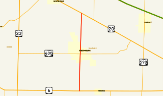
State Route 300 is a 6.33-mile (10.19 km) long north–south state highway in northwestern Ohio, a U.S. state. The southern terminus of SR 300 is at a T-intersection with U.S. Route 6 (US 6) approximately 1.50 miles (2.41 km) west of the village of Helena. Its northern terminus is at US 20 just over 2.50 miles (4.02 km) southeast of Woodville.

Ohio State Route 701 highway in Ohio

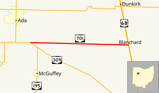
State Route 701 is a 8.96-mile (14.42 km) east–west state highway in western Ohio, a U.S. state. The state highway's western terminus is at a T-intersection with SR 309 nearly 3 miles (4.8 km) southeast of Ada. The eastern terminus of State Route 701 is at U.S. Route 68 (US 68) approximately 3.50 miles (5.63 km) southeast of Dunkirk.

Ohio State Route 366 highway in Ohio

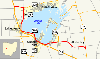
State Route 366 is an east–west state highway in the western portion of the U.S. state of Ohio. SR 366 has its western terminus at a T-intersection with U.S. Route 33 nearly 1.50 miles (2.41 km) northwest of Lakeview. The route's eastern terminus is at State Route 117 about 1.50 miles (2.41 km) north of Huntsville. SR 366 runs along the western and southern edge of Indian Lake and provides access to homes and recreational facilities along the lake shoreline. SR 366 was designated in 1939, and was extended in 1961.

Ohio State Route 368 highway in Ohio

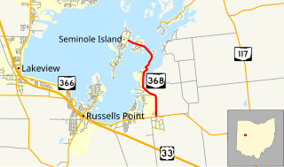
State Route 368 is a short north–south state highway in western Ohio, a U.S. state. SR 368 travels from its southern terminus at SR 366 approximately 1.75 miles (2.82 km) east of Russells Point to its northern terminus on Seminole Island in the eastern half of Indian Lake, at an intersection where it meets Logan County Road 272 (CR 272) and CR 286. Having made its debut in the late 1930s, SR 368 is a two-lane spur route that serves both Indian Lake State Park and communities of cottages that are on two eastern Indian Lake islands: Shawnee and Seminole.

Ohio State Route 540 highway in Ohio

State Route 540 (SR 540) is an east–west state highway in the western portion of the U.S. state of Ohio. SR 540 has its western terminus in downtown Bellefontaine at a signalized intersection with U.S. Route 68 (US 68) and SR 47. Its eastern terminus is at a T-intersection with SR 292 approximately 3.50 miles (5.63 km) southwest of West Mansfield.

Ohio State Route 26 highway in Ohio

State Route 26 is a 67-mile-long (108 km) north–south route in south eastern Ohio spanning from SR 7 in Marietta to SR 148 between Jerusalem and Bethesda. SR 26 also passes through Graysville and Woodsfield. Where the state route designation ends in Wayne Township, the road continues north as Belmont County Road 26 where it connects to the Barkcamp State Park and the National Road. Much of the route parallels the Little Muskingum River and travels through the heart of Wayne National Forest's Marietta Unit.

Ohio State Route 161 highway in Ohio

State Route 161 (SR 161) is an east–west state highway in central Ohio. Its western terminus is in Mutual at State Route 29 and its eastern terminus is near Alexandria at State Route 37. It is 57.46 miles (92.47 km) long. State Route 161 passes through Columbus, Ohio's capital, and a variety of towns including Plain City, Dublin, and New Albany.

Ohio State Route 797 highway in Ohio

State Route 797 was a very short, unsigned north–south state highway in the eastern portion of the U.S. state of Ohio. At the time of its deletion of the route from the state highway system, SR 797 ran from its southern terminus at the U.S. Route 22/U.S. Route 40 concurrency about 4.75 miles (7.64 km) northeast of Zanesville to its northern terminus less than 0.40 miles (0.64 km) to the northwest at Interstate 70 at its exit 160, a diamond interchange. North of the interchange, the road continues to Sonora on Muskingum County Road 52, Sonora Road.

Ohio State Route 372 highway in Ohio

State Route 372 (SR 372) is a very short, two-lane east–west state highway in the southern part of the U.S. state of Ohio. The western terminus of this spur route is at a T-intersection with the concurrency of U.S. Route 23 (US 23) and SR 104 about six and a half miles (10.5 km) north of Waverly. Its eastern terminus is just 0.68 miles (1.09 km) to the east of that point at the boundary of Scioto Trail State Forest. Continuing east of that point is Stoney Creek Road, which traverses through the state forest in the direction of the Scioto River. From its inception in the middle of the 1930s, the primary function of SR 372 has been to provide access to the state forest from the state highway system.

Ohio State Route 605 highway in Ohio

State Route 605 is a 9.38-mile-long (15.10 km) north–south state highway in central Ohio. The southern terminus of SR 605 is at a signalized intersection with U.S. Route 62 in the northeastern Columbus suburb of New Albany. Its northern terminus is also at SR 37, a signalized intersection approximately 3 miles (4.8 km) southeast of Sunbury. The route was designated in 1937, and the northern terminus was moved in 1994.

Ohio State Route 257 highway in Ohio

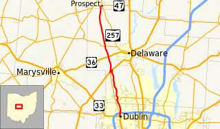
State Route 257 is a 26.19-mile (42.15 km) north - south state highway in the central portion of the U.S. state of Ohio. The highway's southern terminus is in the northwestern Columbus suburb of Dublin at a roundabout intersection with U.S. Route 33 and SR 161. This mainly two-lane highway follows the eastern side of the Scioto River from Dublin to its junction with US 42. After crossing over the river with the U.S. highway, SR 257 parallels the river's western bank. SR 257 has its northern terminus at a T-intersection with SR 47 on the western village limits of Prospect. SR 257 was created in 1926, and extended in 1935 and 1937.

Ohio State Route 800 highway in Ohio

State Route 800 is a north–south state highway in the eastern portion of the U.S. state of Ohio. Its southern terminus is at SR 7 in Jackson Township near New Matamoras, and its northern terminus is at its interchange with Interstate 77 in Canton.

Ohio State Route 664 highway in Ohio

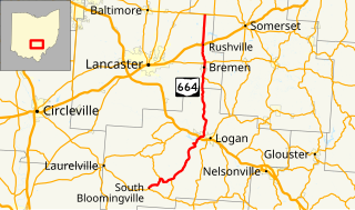
State Route 664 is a north–south state highway in the southern portion of the U.S. state of Ohio. The highway has its southern terminus at a T-intersection with SR 56 in the unincorporated community of South Bloomingville. The northern terminus of SR 664 is also at a T-intersection, this time with SR 256 on the Fairfield–Perry county line approximately 4.75 miles (7.64 km) north of the village of Rushville.

Ohio State Route 313 highway in Ohio

State Route 313 is a 34.38-mile (55.33 km) long east–west state highway located in the southeastern portion of the U.S. state of Ohio. The western terminus of SR 313 is at a T-intersection with SR 146 approximately 9.50 miles (15.29 km) northwest of the village of Cumberland. Its eastern terminus is near the eastern end of Senecaville Lake at a T-intersection with SR 147 nearly 3.50 miles (5.63 km) southwest of Batesville.

Ohio State Route 347 highway in Ohio

State Route 347 (SR 347) is an east–west state highway in central portion of the U.S. state of Ohio. The western terminus of SR 347 is at SR 287 near Middleburg, adjacent to the U.S. Route 33 freeway. Its eastern terminus is at a T-intersection with SR 37 just one-quarter mile (0.40 km) south of the village of Magnetic Springs. The route runs through rural areas of Logan and Union counties passing through no incorporated villages.

Ohio State Route 312 highway in Ohio

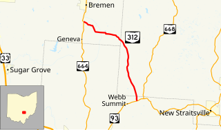
State Route 312 (SR 312) is a north–south state highway located in the southern portion of the U.S. state of Ohio. SR 312 runs from its southern terminus at a T-intersection with SR 93 approximately 4.25 miles (6.84 km) northeast of Logan to its northern terminus at a T-intersection with SR 664 nearly 1.25 miles (2.01 km) south of Bremen.

Ohio State Route 674

State Route 674 is a state highway located southeast of Columbus, Ohio. Most of the route straddles a county line; about 11 miles (18 km) of the southern part of route is on the Pickaway–Fairfield County line while the next 1.4 miles (2.3 km) is on the Fairfield-Franklin County line. The route's southern terminus is at US 22 just north of Stoutsville while the northern terminus is at an interchange with US 33 in the city of Canal Winchester.

References

  1. 1 2 "DESTAPE". Ohio Department of Transportation. July 3, 2014. Retrieved August 31, 2014.
  2. 1 2 Map of Ohio Showing State Highway System (MrSID) (Map). Cartography by ODOH. Ohio Department of Highways. 1930. Retrieved 2011-05-05.
  3. 1 2 Map of Ohio Showing State Highway System (MrSID) (Map). Cartography by ODOH. Ohio Department of Highways. 1931. Retrieved 2011-05-05.
  4. Google (August 31, 2014). "Ohio State Route 287" (Map). Google Maps . Google. Retrieved August 31, 2014.
  5. Official Ohio Highway Map (MrSID) (Map). Cartography by ODOT. Ohio Department of Transportation. 1997. Retrieved 2011-05-05.
  6. Official Ohio Transportation Map (MrSID) (Map). Cartography by ODOT. Ohio Department of Transportation. 1999. Retrieved 2011-05-05.

Route map: Google

KML file (edithelp)
KML is from Wikidata