West Liberty, Ohio

Last updated

West Liberty, Ohio
West Liberty tractor parade.jpg
West Liberty's annual antique tractor parade
OHMap-doton-West Liberty.png
Location of West Liberty, Ohio
Detailed map of West Liberty, Ohio.png
Detailed map of West Liberty
Coordinates: 40°15′12″N83°45′20″W / 40.25333°N 83.75556°W / 40.25333; -83.75556
Country United States
State Ohio
Counties Logan
Townships Liberty, Monroe
Area
[1]
  Total1.22 sq mi (3.15 km2)
  Land1.22 sq mi (3.15 km2)
  Water0.00 sq mi (0.00 km2)
Elevation
[2]
1,198 ft (365 m)
Population
 (2020)
  Total1,770
  Density1,454.40/sq mi (561.47/km2)
Time zone UTC-5 (Eastern (EST))
  Summer (DST) UTC-4 (EDT)
ZIP code
43357
Area code(s) 937, 326
FIPS code 39-83734
GNIS feature ID2400135 [2]
Website www.mywestliberty.com

West Liberty is a village in Logan County, Ohio, United States. The population was 1,770 at the 2020 census.

Contents

History

West Liberty was laid out in 1817. In 1833, West Liberty contained five stores, two taverns, one tannery, a merchant mill, a saw mill, a carding machine, and about 20 residential houses. [3]

Geography

West Liberty, 2021 West Liberty, Ohio (2021).jpg
West Liberty, 2021

According to the United States Census Bureau, the village has a total area of 1.12 square miles (2.90 km2), all of it land. [4]

Flowing along the edge of town is the Mad River, a major source of running water in the area.

Demographics

Historical population
CensusPop.Note
1850 643
1860 91642.5%
1870 741−19.1%
1880 715−3.5%
1900 1,236
1910 1,2884.2%
1920 1,3474.6%
1930 1,248−7.3%
1940 1,228−1.6%
1950 1,39713.8%
1960 1,5228.9%
1970 1,5803.8%
1980 1,6534.6%
1990 1,613−2.4%
2000 1,81312.4%
2010 1,805−0.4%
2020 1,770−1.9%
U.S. Decennial Census [5]

2010 census

As of the census [6] of 2010, there were 1,805 people, 736 households, and 436 families living in the village. The population density was 1,611.6 inhabitants per square mile (622.2/km2). There were 799 housing units at an average density of 713.4 per square mile (275.4/km2). The racial makeup of the village was 96.1% White, 1.3% African American, 0.1% Native American, 0.6% Asian, 0.1% Pacific Islander, 0.2% from other races, and 1.7% from two or more races. Hispanic or Latino of any race were 0.8% of the population.

There were 736 households, of which 29.5% had children under the age of 18 living with them, 45.9% were married couples living together, 9.4% had a female householder with no husband present, 3.9% had a male householder with no wife present, and 40.8% were non-families. 37.9% of all households were made up of individuals, and 21.2% had someone living alone who was 65 years of age or older. The average household size was 2.26 and the average family size was 3.00.

The median age in the village was 41 years. 25.2% of residents were under the age of 18; 7.8% were between the ages of 18 and 24; 21.5% were from 25 to 44; 22.1% were from 45 to 64; and 23.2% were 65 years of age or older. The gender makeup of the village was 44.6% male and 55.4% female.

2000 census

As of the census [7] of 2000, there were 1,813 people, 660 households, and 432 families living in the village. The population density was 1,637.7 inhabitants per square mile (632.3/km2). There were 698 housing units at an average density of 630.5 per square mile (243.4/km2). The racial makeup of the village was 98.46% White, 0.17% African American, 0.28% Native American, 0.28% Asian, 0.11% Pacific Islander, and 0.72% from two or more races. Hispanic or Latino of any race were 0.17% of the population.

There were 660 households, out of which 31.8% had children under the age of 18 living with them, 54.2% were married couples living together, 8.8% had a female householder with no husband present, and 34.4% were non-families. 31.4% of all households were made up of individuals, and 13.2% had someone living alone who was 65 years of age or older. The average household size was 2.36 and the average family size was 2.98.

In the village, the population was spread out, with 23.2% under the age of 18, 6.4% from 18 to 24, 23.5% from 25 to 44, 19.3% from 45 to 64, and 27.6% who were 65 years of age or older. The median age was 43 years. For every 100 females, there were 76.2 males. For every 100 females age 18 and over, there were 70.2 males.

The median income for a household in the village was $38,819, and the median income for a family was $51,193. Males had a median income of $35,000 versus $26,518 for females. The per capita income for the village was $19,083. About 4.9% of families and 5.3% of the population were below the poverty line, including 6.7% of those under age 18 and 5.0% of those age 65 or over.

Government

A branch of the Logan County District Library serves the West Liberty community. [8]

In the elections of November 2007, Rebecca Hamilton and Greg Hostetler were elected to the village council, and Brad Hudson and Dean King were elected to the village's board of public affairs. Cindee Boyd was elected clerk-treasurer without opposition. No candidate filed for the position of mayor. [9] [ needs update ]

Infrastructure

Transportation

U.S. Route 68, known as "Detroit Street", forms the main street in West Liberty. Forming the main east–west street is State Route 245, and its intersection with US 68 is one of the primary intersections of the village. At the far northern end of the village, State Route 508 begins from an intersection with US 68 and heads westward to De Graff.

Notable people

Related Research Articles

<span class="mw-page-title-main">Atwood, Illinois</span> Village in Illinois, United States

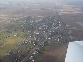
Atwood is a village in Douglas and Piatt counties in Illinois, United States. Main Street runs along the county line with Douglas County to the east and Piatt County to the west. The population was 1,116 at the 2020 census.

<span class="mw-page-title-main">Liberty, Nebraska</span> Village in Nebraska, United States

Liberty is a village in Gage County, Nebraska, United States. The population was 37 at the 2020 census.

<span class="mw-page-title-main">Cherry Fork, Ohio</span> Unincorporated community and Census-designated place in Ohio, United States

Cherry Fork is an unincorporated community and former village in Wayne Township, Adams County, Ohio, United States. The population was 170 at the 2020 census. In 2014, voters chose to disincorporate the village.

<span class="mw-page-title-main">Bridgeport, Ohio</span> Village in Ohio, United States

Bridgeport is a village in eastern Belmont County, Ohio, United States. It lies across the Ohio River from Wheeling, West Virginia, at the mouth of Wheeling Creek and is connected by two bridges to Wheeling Island. The population was 1,582 at the 2020 census. It is part of the Wheeling metropolitan area.

<span class="mw-page-title-main">Bethel, Ohio</span> Village in Ohio, United States

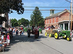
Bethel is a village in Tate Township, Clermont County, Ohio, United States. The population was 2,620 at the 2020 census. Bethel was founded in 1798 by Obed Denham as Denham Town, in what was then the Northwest Territory. Bethel is the home of the first movie theater in Ohio which was founded in 1908 by Aaron Little.

<span class="mw-page-title-main">Vinton, Ohio</span> Village in Ohio, United States

Vinton is a village in Gallia County, Ohio, United States. The population was 224 at the 2020 census. It is part of the rural Point Pleasant micropolitan area.

<span class="mw-page-title-main">Kimbolton, Ohio</span> Census-designated place in Ohio, United States

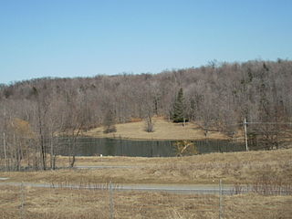
Kimbolton is an unincorporated community and census-designated place in Guernsey County, Ohio, United States, along Wills Creek. The population was 152 at the 2020 census.

<span class="mw-page-title-main">Addyston, Ohio</span> Village in Ohio, United States

Addyston is a village in Miami Township, Hamilton County, Ohio, United States. Located along the Ohio River, it is a western suburb of the neighboring city of Cincinnati. The population was 927 at the 2020 census.

<span class="mw-page-title-main">Liberty Center, Ohio</span> Village in Ohio, United States

Liberty Center is a village in Henry County, Ohio, United States. The population was 1,108 at the 2020 census.

<span class="mw-page-title-main">Stratton, Ohio</span> Village in Ohio, United States

Stratton is a village in northern Jefferson County, Ohio, United States, along the Ohio River. The population was 267 at the 2020 census. It is part of the Weirton–Steubenville metropolitan area.

<span class="mw-page-title-main">West Alexandria, Ohio</span> Village in Ohio, United States

West Alexandria is a village in Preble County, Ohio, United States. The population was 1,334 at the 2020 census.

<span class="mw-page-title-main">McArthur, Ohio</span> Village in Ohio, United States

McArthur is a village in and the county seat of Vinton County, Ohio, United States. It is located 27 miles (43 km) southeast of Chillicothe. The population was 1,783 at the 2020 census.

<span class="mw-page-title-main">West Salem, Ohio</span> Village in Ohio, United States

West Salem is a village in Wayne County, Ohio. The population was 1,430 at the time of the 2020 census. West Salem is served by a branch of the Wayne County Public Library.

<span class="mw-page-title-main">Brady Township, Lycoming County, Pennsylvania</span> Township in Pennsylvania, United States

Brady Township is a township in Lycoming County, Pennsylvania, United States. The population was 502 at the 2020 census. It is part of the Williamsport Metropolitan Statistical Area.

<span class="mw-page-title-main">Liberty Township, Tioga County, Pennsylvania</span> Township in Pennsylvania, United States

Liberty Township is a township in Tioga County, Pennsylvania, United States. The population was 1,037 at the 2020 census.

<span class="mw-page-title-main">West Liberty, West Virginia</span> Town in West Virginia, United States

West Liberty is a town in Ohio County, West Virginia, United States. The population was 1,557 at the 2020 census. It is part of the Wheeling metropolitan area.

<span class="mw-page-title-main">Wilson, Ohio</span> Village in Ohio, United States

Wilson is a village in Belmont and Monroe counties in the U.S. state of Ohio. The population was 129 at the 2020 census. It is part of the Wheeling metropolitan area.

<span class="mw-page-title-main">Yorkville, Ohio</span> Village in Ohio, United States

Yorkville is a village in Belmont and Jefferson counties in the U.S. state of Ohio. The population was 968 at the 2020 census. Yorkville lies within two Metropolitan Statistical Areas; the Belmont County portion is part of the Wheeling metropolitan area, while the Jefferson County portion is part of the Weirton–Steubenville metropolitan area.

<span class="mw-page-title-main">Washingtonville, Ohio</span> Village in Ohio, United States

Washingtonville is a village in northern Columbiana and southern Mahoning counties in the U.S. state of Ohio. The population was 712 at the 2020 census. Southern Washingtonville is included in the Salem micropolitan area, while northern Washingtonville is part of the Youngstown–Warren metropolitan area.

<span class="mw-page-title-main">Ridgeway, Ohio</span> Village in Ohio, United States

Ridgeway is a village in Hardin and Logan counties in the U.S. state of Ohio. The population was 314 at the 2020 census.

References

  1. "ArcGIS REST Services Directory". United States Census Bureau. Retrieved September 20, 2022.
  2. 1 2 U.S. Geological Survey Geographic Names Information System: West Liberty, Ohio
  3. Kilbourn, John (1833). The Ohio Gazetteer, or, a Topographical Dictionary. Scott and Wright. pp.  489 . Retrieved December 12, 2013.
  4. "US Gazetteer files 2010". United States Census Bureau . Retrieved January 6, 2013.
  5. "Census of Population and Housing". Census.gov. Retrieved June 4, 2015.
  6. "U.S. Census website". United States Census Bureau . Retrieved January 6, 2013.
  7. "U.S. Census website". United States Census Bureau . Retrieved January 31, 2008.
  8. "Branches". Logan County Libraries. Retrieved February 26, 2018.
  9. Examiner Staff, The. "Village results", Bellefontaine Examiner, 2007-11-07, p. 2.