Valley Hi, Ohio

Last updated

Valley Hi, Ohio
Mad River Mountain and Valley Hi.jpg
Mad River Mountain, with subdivisions in the hills above
OHMap-doton-Valley Hi.png
Location of Valley Hi, Ohio
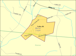
Detailed map of Valley Hi, Ohio.png
Detailed map of Valley Hi
Coordinates: 40°18′58″N83°40′33″W / 40.31611°N 83.67583°W / 40.31611; -83.67583
Country United States
State Ohio
County Logan
Townships Jefferson, Monroe
Area
[1]
  Total0.62 sq mi (1.61 km2)
  Land0.62 sq mi (1.61 km2)
  Water0.00 sq mi (0.00 km2)
Elevation
[2]
1,227 ft (374 m)
Population
 (2020)
  Total228
  Density366.56/sq mi (141.60/km2)
Time zone UTC-5 (Eastern (EST))
  Summer (DST) UTC-4 (EDT)
FIPS code 39-79226 [3]
GNIS feature ID2400039 [2]

Valley Hi is a village in Logan County, Ohio, United States. The population was 228 at the 2020 census. The village is located nearby U.S. Route 33 and is about an hour northwest of Columbus. The village lies mostly in Jefferson Township, but its southernmost portion extends into Monroe Township.

Contents

Geography

Valley Hi has a total area of 0.62 square miles (1.61 km2), all of it land. [4] The village is located in an area with some of the steepest terrain in normally flat Western Ohio and serves as home to the Mad River Mountain ski area.

Demographics

Historical population
CensusPop.Note
1970 15
1980 60300.0%
1990 217261.7%
2000 24412.4%
2010 212−13.1%
2020 2287.5%
U.S. Decennial Census [5]

2010 census

As of the census [6] of 2010, there were 212 people, 87 households, and 53 families residing in the village. The population density was 341.9 inhabitants per square mile (132.0/km2). There were 165 housing units at an average density of 266.1 per square mile (102.7/km2). The racial makeup of the village was 95.8% White, 1.4% African American, 0.9% Native American, 0.5% from other races, and 1.4% from two or more races. Hispanic or Latino of any race were 3.3% of the population.

There were 87 households, of which 36.8% had children under the age of 18 living with them, 37.9% were married couples living together, 13.8% had a female householder with no husband present, 9.2% had a male householder with no wife present, and 39.1% were non-families. 29.9% of all households were made up of individuals, and 4.6% had someone living alone who was 65 years of age or older. The average household size was 2.44 and the average family size was 2.94.

The median age in the village was 32 years. 25.9% of residents were under the age of 18; 12.3% were between the ages of 18 and 24; 28.8% were from 25 to 44; 26.4% were from 45 to 64; and 6.6% were 65 years of age or older. The gender makeup of the village was 51.9% male and 48.1% female.

2000 census

As of the census [3] of 2000, there were 244 people, 97 households, and 65 families residing in the village. The population density was 370.4 inhabitants per square mile (143.0/km2). There were 113 housing units at an average density of 171.5 per square mile (66.2/km2). The racial makeup of the village was 97.95% White, 0.41% Native American, 0.41% Pacific Islander, and 1.23% from two or more races. Hispanic or Latino of any race were 0.82% of the population.

There were 97 households, out of which 39.2% had children under the age of 18 living with them, 50.5% were married couples living together, 10.3% had a female householder with no husband present, and 32.0% were non-families. 23.7% of all households were made up of individuals, and 2.1% had someone living alone who was 65 years of age or older. The average household size was 2.52 and the average family size was 2.98.

In the village, the population was spread out, with 28.3% under the age of 18, 11.9% from 18 to 24, 37.3% from 25 to 44, 16.4% from 45 to 64, and 6.1% who were 65 years of age or older. The median age was 30 years. For every 100 females, there were 106.8 males. For every 100 females age 18 and over, there were 118.8 males.

The median income for a household in the village was $43,125, and the median income for a family was $46,364. Males had a median income of $32,350 versus $26,250 for females. The per capita income for the village was $17,077. About 3.7% of families and 4.7% of the population were below the poverty line, including 4.1% of those under the age of eighteen and none of those 65 or over.

Transportation

Due to its location at the top of the ridgeline, Valley Hi contains only a few winding streets. Moreover, it is not as easily accessed as some nearby towns, as the only road into the village is County Road 291. The nearest highway is U.S. Route 33, which is accessed by an interchange less than a mile from the village.

Related Research Articles

<span class="mw-page-title-main">Whitmore Village, Hawaii</span> Census-designated place in Hawaii, United States

Whitmore Village is a census-designated place (CDP) in Honolulu County, Hawaiʻi, United States. The population was 4,887 at the 2020 census.

<span class="mw-page-title-main">Trommald, Minnesota</span> City in Minnesota, United States

Trommald is a city in Crow Wing County, Minnesota, United States. The population was 99 at the 2020 census. It is part of the Brainerd Micropolitan Statistical Area.

<span class="mw-page-title-main">Marlborough, Missouri</span> Village in Missouri, United States

Marlborough is a village in St. Louis County, Missouri, United States. The population was 2,179 at the 2010 census.

<span class="mw-page-title-main">Elwood, Nebraska</span> Village in Nebraska, United States

Elwood is a village and the county seat of Gosper County, Nebraska, United States. It is part of the Lexington, Nebraska Micropolitan Statistical Area. The population was 707 at the 2010 census.

<span class="mw-page-title-main">Uplands Park, Missouri</span> Village in Missouri, United States

Uplands Park is a village in St. Louis County, Missouri, United States. The population was 445 at the 2010 census. The village is one of many small majority black communities located in the Natural Bridge corridor of mid-St. Louis County, characterized by small homes on small lots.

<span class="mw-page-title-main">Cuyahoga Heights, Ohio</span> Village in Ohio, United States

Cuyahoga Heights is a village in Cuyahoga County, Ohio, United States. The population was 573 at the 2020 census. A suburb of Cleveland, it is a part of the Cleveland metropolitan area.

<span class="mw-page-title-main">Gordon, Ohio</span> Village in Ohio, United States

Gordon is a village in Darke County, Ohio, United States. The population was 245 at the 2020 census.

<span class="mw-page-title-main">Riverlea, Ohio</span> Village in Ohio, United States

Riverlea is a village in Franklin County, Ohio, United States, surrounded by Worthington on its north, south, and east sides, and bordered on the west by the Olentangy River, across which is Columbus. Riverlea was incorporated in 1939, a small community that formed on former farmland. The population was 599 at the 2020 census.
<span class="mw-page-title-main">Valleyview, Ohio</span> Village in Ohio, United States

Valleyview is a village in Franklin County, Ohio, United States. The population was 669 at the 2020 census.

<span class="mw-page-title-main">Addyston, Ohio</span> Village in Ohio, United States

Addyston is a village in Miami Township, Hamilton County, Ohio, United States. Located along the Ohio River, it is a western suburb of the neighboring city of Cincinnati. The population was 927 at the 2020 census.

<span class="mw-page-title-main">Cleves, Ohio</span> City in Ohio, United States

Cleves is a village in Miami Township, Hamilton County, Ohio, United States. Located along the Ohio River, it is a western suburb of Cincinnati. The population was 3,414 at the 2020 census.

<span class="mw-page-title-main">Elmwood Place, Ohio</span> Village in Hamilton County, Ohio, United States

Elmwood Place is a village in Hamilton County, Ohio, United States. The population was 2,087 at the 2020 census. Except for a small portion which touches neighboring St. Bernard, Elmwood Place is nearly surrounded by the city of Cincinnati.

<span class="mw-page-title-main">Lowellville, Ohio</span> Village in Ohio, United States

Lowellville is a village in eastern Mahoning County, Ohio, United States, along the Mahoning River. The population was 996 at the 2020 census. Located about 8 miles (13 km) southeast of Youngstown, it is part of the Youngstown–Warren metropolitan area.

<span class="mw-page-title-main">Tarlton, Ohio</span> Village in Ohio, United States

Tarlton is a village in Fairfield and Pickaway counties in the U.S. state of Ohio. The population was 254 at the 2020 census.
<span class="mw-page-title-main">Macksburg, Ohio</span> Village in Ohio, United States

Macksburg is a village in Washington County, Ohio, United States, along the West Fork of Duck Creek. The population was 120 at the 2020 census. The village is about 28 miles (45 km) south of Cambridge, Ohio.

<span class="mw-page-title-main">Bellevue, Wisconsin</span> Village in Wisconsin, United States

Bellevue is a village in Brown County, Wisconsin. It was a town until incorporating as a village on February 14, 2003. The population was 15,935 at the time of the 2020 census. Bellevue is part of the Green Bay metropolitan area. Bellevue sits around 4.34 miles (6.99 km) east from central Green Bay.

<span class="mw-page-title-main">Kekoskee, Wisconsin</span> Village in Wisconsin, United States

Kekoskee is a village in Dodge County, Wisconsin, United States. The population was 161 at the 2010 census.

<span class="mw-page-title-main">Avoca, Wisconsin</span> Village in Wisconsin, United States

Avoca is a village in Iowa County, Wisconsin, United States. The population was 637 at the 2010 census. It is part of the Madison Metropolitan Statistical Area. It is named after Avoca in Ireland.

<span class="mw-page-title-main">Wilson, Ohio</span> Village in Ohio, United States

Wilson is a village in Belmont and Monroe counties in the U.S. state of Ohio. The population was 129 at the 2020 census. It is part of the Wheeling metropolitan area.

<span class="mw-page-title-main">Verona, Ohio</span> Village in Ohio, United States

Verona is a village in Montgomery and Preble counties in the U.S. state of Ohio. The population was 403 at the 2020 census. It is part of the Dayton Metropolitan Statistical Area.

References

  1. "ArcGIS REST Services Directory". United States Census Bureau. Retrieved September 20, 2022.
  2. 1 2 U.S. Geological Survey Geographic Names Information System: Valley Hi, Ohio
  3. 1 2 "U.S. Census website". United States Census Bureau . Retrieved January 31, 2008.
  4. "US Gazetteer files 2010". United States Census Bureau. Archived from the original on January 25, 2012. Retrieved January 6, 2013.
  5. "Census of Population and Housing". Census.gov. Retrieved June 4, 2015.
  6. "U.S. Census website". United States Census Bureau . Retrieved January 6, 2013.