Pola Island

Last updated
Cockscomb Point as seen jutting into the ocean. Pola island.jpg
Cockscomb Point as seen jutting into the ocean.
Pola Island Pola Islands Tutuila NPS.jpg
Pola Island

Pola Island (Samoan: Motu o Pola) is an island just offshore from the village of Vatia on Tutuila Island in American Samoa. It is also known as Cockscomb. [1] :274 [2] [3] [4] [5] :177 Pola Island is designated as part of the National Park American Samoa, and is a popular tourist attraction. [6] It is located on the west side of Vatia Bay, and serves as both a landmark and an icon for Vatia. Pola Island has been named one of American Samoa's Seven National Wonders by the Pago Pages. [7] :50 It has been named "the most beautiful natural feature of Tutuila Island” by travel guide publisher Lonely Planet . [5] :177 Pola Island is known for its high cliffs, populated by seabirds, [8] [9] and is one of American Samoa's primary seabird nesting sites. [10]

Contents

Etymology

Pola Tai and Pola Uta, 1907. ETH-BIB-Friedlaender-Samoa, Vatia, Tutuila-Hs 0625a-0003-169.tif
Pola Tai and Pola Uta, 1907.

According to the late High Orator Nanai Afuola Kalasa, the most senior chief authority, the island is directly linked to a legend about the village's creation. A couple sailed westward from the Manu'a Islands with their daughter, with the hopes of reaching Upolu Island. A few days later, they struggled with rough seas and the raft gave up on them. All the three perished and mutated into rocks. The couple was Pola and Pola, while the daughter was Faleofia. These rock forms are named after this couple. Uta translates to “closer to land”, and Pola'uta is the name of the ridge on the opposite side of the strait. “Tai” translates to “further from land”, and Pola Tai is a name used for Pola Island. [7] :49

Geography and geology

Vai'ava Strait National Natural Landmark AmSamoa Tutuila 491.jpg
Vai'ava Strait National Natural Landmark
Pola Tai, Pola'uta Ridge and Vatia as seen from the Mount Alava Adventure Trail. Pola Tai view from Mount Alava Adventure Trail.jpg
Pola Tai, Pola'uta Ridge and Vatia as seen from the Mount Alava Adventure Trail.
National Park sign American Samoa National Park sign for Pola Island.jpg
National Park sign

The island is separated from land by the Vai'ava Strait. [4] [7] :66 Vai'ava Strait National Natural Landmark makes up 250 acres and is the only U.S. National Natural Landmark in American Samoa which is also part of the National Park of American Samoa. [1] :284 Passing east through the town of Vatia, the road ends at the Pola Island trailhead. A short path leads to a large cobblestone beach. Two sea arches are visible from the base of the cliffs extending into the ocean. [11]

Pola Scenic Point is located on the road into Vatia village. This observation site overlooks Pola Island and the Vai'ava Strait National Natural Landmark. [7] :47 Pola Island is a prominent basalt sea stack with steep cliffs and scenic forest-covered headlands. It is an important nesting place for at least eight seabird species. All of Pola Island and the eastern parts of Polauta Ridge contain undisturbed forest. [12]

Erosion by the sea has sculpted the cliffs and sea arches in the rocks of the huge volcanic plug known as Pola Island. The rock formations of Pola Island resemble a dinosaur tail jutting 3,500 feet out into the sea. [1] :278,284 It is a rugged and sharp igneous basaltic outcrop. [13]

Accessibility

Eastern point of Vatia Bay. Line4393 - Flickr - NOAA Photo Library.jpg
Eastern point of Vatia Bay.

Passing east through the village of Vatia, the Pola Island trailhead is located at the end of the road. The trailhead is beyond the school, and a short trail leads into the National Park. The trail ends at a rocky cliff which points across Vai'ava Strait to Pola Island. There is no access to the island itself. [5] :177

North Shore Tours offer boat tours to Pola Island, which is the most photographed site on Tutuila Island. [14]

Climate

The rainfall in the area is from 149 to 252 inches (3,800 to 6,400 millimetres) annually. The temperature is around 71-73 degrees Fahrenheit. [13]

Wildlife

Avifauna

In American Samoa Red-footed boobies are only found in the Pola area Rose Atoll. Sula sula nesting in Heliotropium foertherianum.jpg
In American Samoa Red-footed boobies are only found in the Pola area Rose Atoll.

The island has 394 feet high cliffs populated by seabirds. [8] [9] Pola Island has been described as American Samoa's "top seabird nesting site." [10] Pola Island and nearby Pola'uta Ridge are American Samoa's most important nesting and roosting areas for several seabird species. The only breeding colonies of Red-footed boobies in American Samoa are Rose Atoll and Pola Island including nearby Pola'uta Ridge. [15] [7] :59

The Pola region of Vatia is the most important roosting and nesting sites in American Samoa for numerous species of seabirds. Some bird species here include: [16]

Bridled terns are rare visitors in American Samoa, however, they have been recorded at Pola Island. Pola Island is the primary breeding area for boobies and frigatebirds on Tutuila Island. [17]

Hunting

Hunting of Brown boobies, known as A'ega o le Pola, was a tradition in the past. However, the birds were over-hunted due to the use of shotguns and remained gone from the Pola area until recently. [7] :66 The eggs from Brown boobies were considered a delicacy for nearby Vatia residents. [13]

See also

Related Research Articles

National Park of American Samoa United States national park in American Samoa

The National Park of American Samoa is a national park in the United States territory of American Samoa, distributed across three islands: Tutuila, Ofu, and Ta‘ū. The park preserves and protects coral reefs, tropical rainforests, fruit bats, and the Samoan culture. Popular activities include hiking and snorkeling. Of the park's 8,257 acres (3,341 ha), 2,500 acres (1,000 ha) is coral reefs and ocean. The park is the only American National Park Service system unit south of the equator.

Vostok Island

Vostok Island is an uninhabited coral island in the central Pacific Ocean, part of the Line Islands belonging to Kiribati. Other names for the island include Anne Island, Bostock Island, Leavitts Island, Reaper Island, Wostock Island or Wostok Island. The island was first sighted in 1820 by the Russian explorer Fabian Gottlieb von Bellingshausen, who named the island for his ship Vostok.

Great frigatebird Species of bird (Fregata minor)

The great frigatebird is a large seabird in the frigatebird family. There are major nesting populations in the tropical Pacific and Indian Oceans, as well as a tiny population in the South Atlantic.

Kilauea Point National Wildlife Refuge

Kīlauea Point National Wildlife Refuge is a National Wildlife Refuge on the northwest coast of the island of Kauaʻi in Hawaiʻi.

Vaiʻava Strait

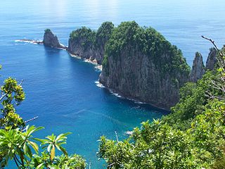
Vaiʻava Strait is the name of a narrow strait located in Vatia, American Samoa. It is a 250 acres (100 ha) National Natural Landmark. The strait is a great example of cliffs formed by waves on volcanic rock. The strait consists of communal lands. It was designated as a U.S. National Natural Landmark in 1972. Vai'ava Strait separates the 420 feet (130 m) high Pola Tai Island from Polauta Ridge. Pola-Uta is connected to the village of Vatia on Tutuila Island. Pola Tai is a 400 feet (120 m) cliff that is an important nesting area for the fua'ō and tava'e. Hunting of brown boobies, known as the A'ega o le Pola, was a tradition carried out by Vatians in the past. Pola Tai includes Matalia Point, Cockscomb Point and Polauta Ridge.

Rainmaker Mountain

Rainmaker Mountain is the name of a mountain located near Pago Pago, American Samoa on Tutuila Island. Rainmaker Mountain traps rain clouds and gives Pago Pago the highest annual rainfall of any harbor. The average annual rainfall on the mountain is around 200 inches. It has a three-pronged summit. Rainmaker Mountain and its base were designated a National Natural Landmark in 1972 due to the slopes’ tropical vegetation.

Fauna of the Cocos (Keeling) Islands

The terrestrial fauna of the Cocos (Keeling) Islands is unsurprisingly depauperate, because of the small land area of the islands, their lack of diverse habitats, and their isolation from large land-masses. However, the fauna dependent on marine resources is much richer.

Battowia

Battowia or Bettowia is one of the Grenadine islands which lie between the Caribbean islands of Saint Vincent and Grenada. Politically, it is part of the nation of Saint Vincent and the Grenadines.

Nuuuli, American Samoa Village in American Samoa, United States

Nu'uuli is a village on the central east coast of Tutuila Island, American Samoa. It is located on a peninsula several miles up from Pago Pago International Airport. Nu’uui is located between Pago Pago International Airport and Coconut Point. It is a shopping district which is home to stores such as South Pacific Traders, Nu’uuli Shopping Center, Aiga Supermarket and many more shops.

Afono Village in American Samoa, United States

Āfono is a village on the northeast coast of Tutuila Island, American Samoa. One of the island's more populous villages, it is located on the edge of Afono Bay, at the eastern edge of the National Park of American Samoa. It is connected by Highway 6 to Vatia, which lies along the coast to the northwest, and to Aua, on the edge of Pago Pago Harbor to the south via a winding stretch of highway which crosses the spine of the island.

Futiga Village in American Samoa, United States

Futiga is a village in the southwest of Tutuila Island, American Samoa. It is located inland, seven miles southwest of Pago Pago, between the villages of 'Ili'ili and Leone. It is in Tualatai County.

Cape Taputapu Cape in American Samoa

Cape Taputapu is the name of a cape located in the Western District of American Samoa. Located in Tutuila, it is the island's westernmost point. The cape was designated as a National Natural Landmark in 1972.

Vatia, American Samoa Village in American Samoa, United States

Vatia is a village on Tutuila Island in American Samoa. It is a north shore village located on Vatia Bay. The road to Vatia, American Samoa Highway 006, is the only road going through National Park of American Samoa. Vatia is a scenic community at the foot of Pola Ridge and surrounded by the national park. It is only reached by Route 6 which traverses the national park before reaching Vatia. There was once a hiking trail over Maugaloa Ridge from Leloaloa, but since the completion of Route 6, this trail is now overgrown. It is home to a beach, and panoramic views of jungle-covered peaks surround the village on all sides. Vatia is the center of the Tutuila-section of National Park of American Samoa. It is located in Vaifanua County.

Tula, American Samoa Village in American Samoa, United States

Tula is a village in the Eastern District of Tutuila Island in American Samoa. Tula is located in Vaifanua County and had a population of 405 as of the 2010 U.S. Census.

Fagasa, American Samoa Village in American Samoa, United States

Fagasā is a village in the Eastern District of Tutuila Island in American Samoa. The village lies by Fagasa Bay, on the north shore of the island. Its name is Samoan and translates to “Forbidden Bay.” The village borders the Tutuila-section of National Park of American Samoa. The trailhead to Mount ‘Alava is located near the village by Fagasa Pass.

Fagamalo, American Samoa

Fagamalo was in 2010 the first village in American Samoa to create a designated protected marine area. It is a village on the north shore's backside of Tutuila Island. The village was for long only reached by narrow trails over rugged vertical terrain. The trails were often obscured by brush and seldom traveled as they traversed the thick rain forests. It often required hours of hiking before reaching the village. Route 1 now climbs steeply and winds up to the village of Fagamalo, where the road ends. It is located in Lealataua County in the Western District of Tutuila Island.

Amalau is the name of a valley and a bay within the National Park of American Samoa. Amalau Valley is located between Vatia and Afono, and it is an isolated valley with various wildlife such as large numbers of native bird species and flying fox megabats. Amalau Valley is reached on the road leading to Vatia. There are only a few homes at Amalau.

References

  1. 1 2 3 Goldin, Meryl Rose (2002). Field Guide to the Samoan Archipelago: Fish, Wildlife, and Protected Areas. Bess Press.  ISBN   9781573061117.
  2. Stanley, David (2004). Moon Handbooks South Pacific. Moon Travel Guides. Page 479. ISBN   9781566914116.
  3. Schyma, Rosemarie (2013). Südsee. DuMont Reiseverlag. Page 267. ISBN   9783770176946.
  4. 1 2 Harris, Ann G. and Esther Tuttle (2004). Geology of National Parks, Volume 2. Kendall Hunt. Page 609.  ISBN   9780787299705.
  5. 1 2 3 Swaney, Deanna (1994). Samoa: Western & American Samoa: a Lonely Planet Travel Survival Kit. Lonely Planet Publications. ISBN   9780864422255.
  6. Sunia, Fofo I.F. (2009). A History of American Samoa. Amerika Samoa Humanities Council. Page 332.  ISBN   9781573062992.
  7. 1 2 3 4 5 6 Fai’ivae, Alex Godinet (2018). Ole Manuō o Tala Tu’u Ma Fisaga o Tala Ave. Amerika Samoa Humanities Council. ISBN   9781546229070.
  8. 1 2 Pitts, Christopher and Amy C. Balfour (2016). Lonely Planet USA’s National Parks. Lonely Planet. Page 451. ISBN   9781760342609.
  9. 1 2 Rawlings-Way, Charles and Brett Atkinson (2016). Lonely Planet Pacific. Lonely Planet. Page 301. ISBN   9781786577344.
  10. 1 2 https://www.nzherald.co.nz/travel/news/article.cfm?c_id=7&objectid=12203125
  11. Kroese, David (2019). The Centennial: A Journey Through America’s National Park System. Wheatmark, Inc. Page 547. ISBN   9781627876575.
  12. http://www.npshistory.com/publications/npsa/feasibility-study.pdf (Page 61)
  13. 1 2 3 http://www.botany.hawaii.edu/basch/uhnpscesu/pdfs/sam/Suafoa2000AS.pdf (Page 208)
  14. Hughes, Holly (2010). Frommer’s 500 Extraordinary Islands (500 Places). Frommer’s. Page 87. ISBN   9780470500705
  15. http://npshistory.com/publications/npsa/nrr-2019-1894.pdf (Page 183)
  16. U.S. Department of the Interior/National Park Service (1997). ”National Park of American Samoa, General Management Plan (GP), Islands of Tutulla, Ta'u, and Ofu: Environmental Impact Statement.” Page 129.
  17. https://www.nps.gov/npsa/learn/nature/upload/2nded05J.pdf (Page 94)

Coordinates: 14°14′03″S170°40′14″W / 14.2342°S 170.6706°W / -14.2342; -170.6706