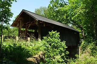
The Gates Farm Covered Bridge is a covered bridge that crosses the Seymour River off State Route 15 in Cambridge, Vermont. Built in 1897, it is last bridge to be built during the historic period of covered bridge construction with the Burr arch design. It was listed on the National Register of Historic Places in 1974.

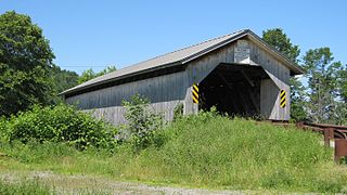
The East Fairfield Covered Bridge is a covered bridge that carries Bridge Street across Black Creek in the East Fairfield village of Fairfield, Vermont. Built about 1865, it is the town's only surviving 19th century covered bridge. It was listed on the National Register of Historic Places in 1974.

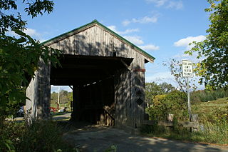
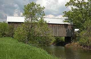
The Poland Covered Bridge, also known as the Junction Covered Bridge or the Cambridge Junction Covered Bridge is a covered bridge that carries Cambridge Junction Road across the Lamoille River off State Route 15 in Cambridge, Vermont. It was listed on the National Register of Historic Places in 1974. The bridge is of Burr arch design, built by George W. Holmes in 1887.

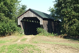
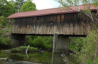
The Grist Mill Covered Bridge, also known as the Scott Covered Bridge, the Bryant Covered Bridge, and the Canyon Covered Bridge, is a covered bridge that carries Canyon Road across the Brewster River, off Vermont Route 108 in Cambridge, Vermont. Built in the 19th century, it is one of a small number of surviving Burr arch truss bridges in the state, and is one of three left in Cambridge. It was listed on the National Register of Historic Places in 1974.
The Scribner Covered Bridge, also known as the Mudgett Covered Bridge, is a covered bridge that carries Rocky Road across the Gihon River off State Route 100C in eastern Johnson, Vermont. It was listed on the National Register of Historic Places in 1974. It is one of a small number of Vermont's covered bridges that are the result of covering an existing open bridge.

The Cedar Swamp Covered Bridge, also known as the Station Bridge and by various other names, was a historic wooden covered bridge spanning Otter Creek between Cornwall and Salisbury, Vermont. The Town lattice truss bridge was built in 1864-1865 and added to the National Register of Historic Places in 1974. It was destroyed by fire in September 2016.
The Holmes Creek Covered Bridge, also called the Lakeshore Covered Bridge, is a one-lane wooden covered bridge that crosses Holmes Creek in Charlotte, Vermont on Lake Road, adjacent to Charlotte Beach. It was listed on the National Register of Historic Places in 1974.

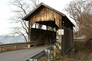
The Pulp Mill Covered Bridge, also called the Paper Mill Covered Bridge, is a wooden covered bridge that crosses Otter Creek between Middlebury and Weybridge, Vermont on Seymour Street. It was listed on the National Register of Historic Places in 1974.
The Gifford Covered Bridge, also called the C.K. Smith Covered Bridge, is a wooden covered bridge that crosses the Second Branch of the White River in Randolph, Vermont on Hyde Road. It was listed on the National Register of Historic Places in 1974. It is one of two bridges in the state that was uncovered when first built, its trusses boxed for shelter.

The Kingsbury Covered Bridge, also called the Hyde Covered Bridge, is a wooden covered bridge that carries Kingsbury Road across the Second Branch of the White River in Randolph, Vermont. Built in 1904, it is last documented covered bridge to be built in Vermont during the historic 19th and early 20th century period. It was listed on the National Register of Historic Places in 1974.

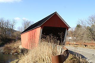
The Great Eddy Covered Bridge, also called the Big Eddy Covered Bridge or Waitsfield Covered Bridge, is a wooden covered bridge that crosses the Mad River in Waitsfield, Vermont on Bridge Street. Built in 1833, it is one of Vermont's oldest covered bridges. It was listed on the National Register of Historic Places in 1974.
The Seguin Covered Bridge, also called the Upper Covered Bridge and the Sequin Covered Bridge, is a wooden covered bridge that crosses Lewis Creek in Charlotte, Vermont on Roscoe Road. It was built about 1850, and is a distinctive variant of a Burr arch design. It was listed on the National Register of Historic Places in 1974.
The Hopkins Covered Bridge is a wooden covered bridge that crosses the Trout River in Enosburg, Vermont on Hopkins Bridge Road. Built in 1875 by brothers Sheldon & Savannah Jewett, it is one of a cluster of area covered bridges all attributed to the same builders. It was listed on the National Register of Historic Places in 1974.

The Mill Covered Bridge is a wooden covered bridge that crosses the North Branch Lamoille River on Back Road in Belvidere, Vermont. Built about 1890, it is one of two surviving covered bridges in the rural community. It was listed on the National Register of Historic Places in 1974.

The Morgan Covered Bridge, also known as the Upper Covered Bridge is a wooden covered bridge that crosses the North Branch Lamoille River in Belvidere, Vermont on Morgan Bridge Road. Built about 1887, it is one of two covered bridges in Belvidere, and one of five in a five-mile span that all cross the same river. It was listed on the National Register of Historic Places in 1974.

The Montgomery Covered Bridge, also known as the Lower Covered Bridge is a wooden covered bridge that carries Montgomery Road across the North Branch of the Lamoille River in Waterville, Vermont. Built in 1887, it is one of three covered bridges in the town, and one of five on the river in a five-mile span. It was listed on the National Register of Historic Places in 1974.

The Gorham Covered Bridge carries Gorham Bridge Road across Otter Creek in a rural area of Pittsford and Proctor, Vermont. It is a Town lattice truss bridge, built in 1841 by Abraham Owen and Nicholas M. Powers, the latter in the early stages of his career as a well-known bridgewright. The bridge was listed on the National Register of Historic Places in 1974.
The Howe Covered Bridge is a historic covered bridge carrying Belknap Brook Road across the White River in Tunbridge, Vermont, just east of Vermont Route 110. Built in 1879, it is one of five surviving bridges in the town, one of the highest concentrations of covered bridges in the state. It was listed on the National Register of Historic Places in 1974.
The Thetford Center Covered Bridge is a historic covered bridge, carrying Tucker Hill Road across the Ompompanoosuc River in Thetford, Vermont. It is the state's only known example of the Haupt patent truss system. It was listed on the National Register of Historic Places in 1974.

The Jaynes Covered Bridge is a historic covered bridge, carrying Codding Hollow Road across the North Branch Lamoille River in Waterville, Vermont. Built in 1877, it is one of three 19th-century covered bridges in the town, and one of five to span the North Branch Lamoille in a five-mile span. It was listed on the National Register of Historic Places in 1974.


