Rayon Terrace, Virginia

Last updated

Rayon Terrace is an unincorporated community in Alleghany County, Virginia, United States.

Alleghany County, Virginia County in the United States

Alleghany County is an American county located on the far western edge of Commonwealth of Virginia. It is bordered by the Allegheny Mountains, from which the county derives its name, and it is the northernmost part of the Roanoke Region. The county seat is Covington.

Virginia State of the United States of America

Virginia, officially the Commonwealth of Virginia, is a state in the Southeastern and Mid-Atlantic regions of the United States located between the Atlantic Coast and the Appalachian Mountains. The geography and climate of the Commonwealth are shaped by the Blue Ridge Mountains and the Chesapeake Bay, which provide habitat for much of its flora and fauna. The capital of the Commonwealth is Richmond; Virginia Beach is the most populous city, and Fairfax County is the most populous political subdivision. The Commonwealth's estimated population as of 2018 is over 8.5 million.

United States Federal republic in North America

The United States of America (USA), commonly known as the United States or America, is a country comprising 50 states, a federal district, five major self-governing territories, and various possessions. At 3.8 million square miles, the United States is the world's third or fourth largest country by total area and is slightly smaller than the entire continent of Europe's 3.9 million square miles. With a population of over 327 million people, the U.S. is the third most populous country. The capital is Washington, D.C., and the largest city by population is New York City. Forty-eight states and the capital's federal district are contiguous in North America between Canada and Mexico. The State of Alaska is in the northwest corner of North America, bordered by Canada to the east and across the Bering Strait from Russia to the west. The State of Hawaii is an archipelago in the mid-Pacific Ocean. The U.S. territories are scattered about the Pacific Ocean and the Caribbean Sea, stretching across nine official time zones. The extremely diverse geography, climate, and wildlife of the United States make it one of the world's 17 megadiverse countries.

Rayon Terrace is a village in the city of Covington, Virginia. It was formerly called and is generally still referred to South Covington. The village takes its name from the former Rayon Industrial Plant that opened in the 1920s. After the Rayon Plant closed in 1961, the plant was then taken over by Hercules, Incorporated.

Village Small clustered human settlement smaller than a town

A village is a clustered human settlement or community, larger than a hamlet but smaller than a town, with a population ranging from a few hundred to a few thousand. Though villages are often located in rural areas, the term urban village is also applied to certain urban neighborhoods. Villages are normally permanent, with fixed dwellings; however, transient villages can occur. Further, the dwellings of a village are fairly close to one another, not scattered broadly over the landscape, as a dispersed settlement.

Covington, Virginia Independent city in Virginia, United States

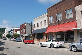
Covington is an independent city in the Commonwealth of Virginia. As of the 2010 census, the population was 5,961, making it the third-least populous city in Virginia. It is surrounded by Alleghany County, of which it is also the county seat. Located at the confluence of Jackson River and Dunlap Creek, Covington is one of three cities in the Roanoke Regional Partnership. The Bureau of Economic Analysis combines the city of Covington with Alleghany county for statistical purposes.

Rayon Terrace is one of the quieter neighborhoods in the city of Covington with one church, six small businesses, a small ballfield, and plenty of mountains to view. There was also a small post office located at the corner of Jackson and Kadel streets until it was closed in the 1970s.

Related Research Articles

Covington County, Mississippi County in the United States

Covington County is a county located in the U.S. state of Mississippi. As of the 2010 census, the population was 19,568. Its county seat is Collins. The county is named for U.S. Army officer and Congressman Leonard Covington.

Covington, Tennessee City in Tennessee, United States of America

Covington is a city in central Tipton County, Tennessee, United States. Covington is the largest city and county seat of Tipton County. The city is located in West Tennessee, 12 mi (19 km) east of the Mississippi River. The city's population was 9,038 at the time of the 2010 U.S. Census. Located 42 mi (68 km) northeast of Memphis, Covington is part of the Memphis, Tennessee Metropolitan Area.

Heaters, West Virginia Unincorporated community in West Virginia, United States

Heaters is a small unincorporated community in Braxton County, West Virginia, United States. Heaters is situated about three miles north of Flatwoods on U.S. Route 19, which is a paved two-lane road. Access to I-79 is at exit 67 in Flatwoods. Heater's has a United States Postal Service post office and the ZIP Code is 26627.

The Village is an area of the Scottish new town East Kilbride, in South Lanarkshire.

Greenwood Mountain is the name of several mountain summits in the United States.

Tasley, Virginia human settlement in United States of America

Tasley is a census-designated place (CDP) in Accomack County, Virginia, United States. The population as of the 2010 Census was 300.

Washington Park is a Roanoke, Virginia neighborhood located in central Roanoke, that initially developed in the 1920s as an early Roanoke suburb. It borders the neighborhoods of Roundhill on the north and Williamson Road on the north and east, Gainsboro and Harrison on the south and Melrose-Rugby on the west. Its northern and eastern boundary is concurrent with Interstate 581 and its southern boundary is concurrent with U.S. Route 460. As of the 2000 Census Harrison has a population of 1,254 residents with 531 households.

Westview Terrace is a Roanoke, Virginia neighborhood located in northwest Roanoke. It borders the neighborhoods of Peachtree/Norwood on the west, Villa Heights and Washington Heights on the south and Miller Court/Arrowood on the north and east. The neighborhood is predominantly residential in character throughout its area with limited commercial development along its Virginia State Route 117 frontage. Its development patterns typical of those experienced for an American city during the mid-20th century with low-density housing.

Fort Carpenter, Alleghany County, Virginia, was built about 1755-1756 by Joseph Carpenter, who migrated from the Province of New York to "the big bend" of the Jackson River on the Virginia frontier about 1745-1746. It was actually a fortified house, or blockhouse. Located on a low bluff near the mouth of Carpenter Creek, it was later known as Cedar Hill. Logs and stones from the original structure were used in the later dwelling now on the site. A young George Washington visited the string of frontier forts during the French and Indian War in 1756, inspecting Fort Young on the north side of the Jackson River, and Fort Carpenter, described as a fortified house, on the south side.

Dunlap Creek is a 25.9-mile-long (41.7 km) tributary of the Jackson River in the U.S. state of Virginia. It is part of the James River watershed.

Carpenter Mountain is located in Alleghany County, Virginia.

Ethel is an unincorporated community in Richmond County, in the U.S. state of Virginia.

Rileyville, Virginia human settlement in Virginia, United States of America

Rileyville is an unincorporated community in Page County, in the U.S. state of Virginia.

Gilmer Terrace is an unincorporated community in Pittsylvania County, in the U.S. state of Virginia.

Snow Mountain Air Force Station

Snow Mountain Air Force Station is a closed United States Air Force General Surveillance Radar station. It is located 1.9 miles (3.1 km) west-southwest of Godman Army Airfield, Kentucky. It was closed in 1968.

Gamerco, New Mexico Unincorporated community in New Mexico, United States

Gamerco is an unincorporated community in McKinley County, New Mexico, United States. As of the 2010 Census, the community population was 1,956. Gamerco was used as a base for coal mining until the 1960s.

Casey Field is baseball ballpark located in Covington, Virginia. Games were first played there in 1962 and it served as the home of the Covington Red Sox in 1967 and the Covington Astros from 1968 to 1976. The field is currently home of the Covington Lumberjacks of the Valley Baseball League. It also hosts football games.

Alum Creek is a stream in the U.S. state of West Virginia. It is a tributary of Tug Fork.

References

Coordinates: 37°45′54″N79°59′46″W / 37.76500°N 79.99611°W / 37.76500; -79.99611

Geographic coordinate system Coordinate system

A geographic coordinate system is a coordinate system that enables every location on Earth to be specified by a set of numbers, letters or symbols. The coordinates are often chosen such that one of the numbers represents a vertical position and two or three of the numbers represent a horizontal position; alternatively, a geographic position may be expressed in a combined three-dimensional Cartesian vector. A common choice of coordinates is latitude, longitude and elevation. To specify a location on a plane requires a map projection.