
Lockhart is a census-designated place in Orange County, Florida, United States. The population was 13,060 at the 2010 census. It is part of the Orlando–Kissimmee–Sanford, Florida Metropolitan Statistical Area. The community is named for David Lockhart.
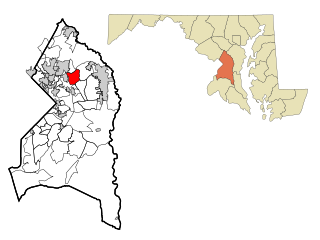
Lanham-Seabrook was a census-designated place (CDP) in Prince George's County, Maryland, in the United States, for the 2000 census. For the 2010 census, the area was delineated as two separate CDPs, Lanham and Seabrook.

Wheaton is a city in Traverse County, Minnesota, United States. The population was 1,460 at the 2020 census. It is the county seat.

Yorketown is an unincorporated community and census-designated place (CDP) within Manalapan Township, in Monmouth County, in the U.S. state of New Jersey. At the 2020 census, the CDP's population was 6,739.
Lake Erie Beach is a hamlet and census-designated place (CDP) in the town of Evans, Erie County, New York, United States. The population was 3,872 at the 2010 census. It is part of the Buffalo–Niagara Falls Metropolitan Statistical Area.
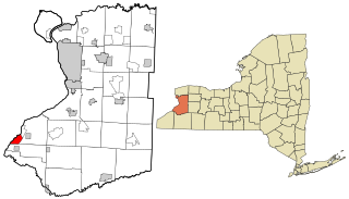
Highland Mills is a hamlet and former census-designated place (CDP) in Orange County, New York, United States. The population was 3,468 at the 2000 census. It is part of the Poughkeepsie–Newburgh–Middletown, NY Metropolitan Statistical Area as well as the larger New York–Newark–Bridgeport, NY-NJ-CT-PA Combined Statistical Area.

Welcome is a census-designated place (CDP) in Davidson County, North Carolina, United States. The population was 4,162 at the 2010 census. It is nationally known as the home of Richard Childress Racing. In addition, Walker and Associates, Inc., a nationwide communication value-add distribution is headquartered here. The town motto is "Welcome to Welcome, A Friendly Place," as posted on the welcoming sign. Neighboring communities and municipalities include Midway, Arcadia, and Lexington.

Midway is an unincorporated census-designated place in Adams County, Pennsylvania, United States. The population was 1,059 at the 2020 census.
Jacksonville is a census-designated place (CDP) in Indiana County, Pennsylvania, United States. The population was 637 at the 2010 census. It was formerly an independent borough, until January 1, 1993 when it was returned to Black Lick Township, Pennsylvania.

Wickerham Manor-Fisher is a census-designated place (CDP) in Washington County, Pennsylvania, United States. The population was 1,728 at the 2010 census.
Lawson Heights is a census-designated place (CDP) in Unity Township, Westmoreland County, Pennsylvania, United States. The population was 2,339 at the 2000 census.

Harrisville is a census-designated place (CDP) and village in the town of Burrillville in Providence County, Rhode Island, United States. The population was 1,605 at the 2010 census. Much of the community composes a historic district listed on the National Register of Historic Places. The village was named after nineteenth century manufacturer Andrew Harris. Previously, the village was named Rhodesville, after Captain William Rhodes, an eighteenth century privateer.
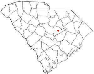
South Sumter is a census-designated place (CDP) in Sumter County, South Carolina, United States. The population was 3,365 at the 2000 census. It is included in the Sumter, South Carolina Metropolitan Statistical Area.
Cottonwood West was a census-designated place (CDP) in Salt Lake County, Utah, United States. The CDP was situated between the cities of Holladay and Murray, which by the mid-2000s had annexed virtually all of the area between them.

Navajo Mountain is a census-designated place (CDP) on the Navajo Nation in southwestern San Juan County, Utah, United States. The 2020 census was recorded as 450.
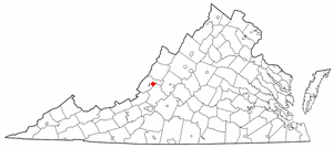
Low Moor is a census-designated place (CDP) in Alleghany County, Virginia. The population was 258 at the 2010 census.
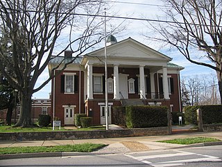
Rustburg is a census-designated place (CDP) in and the county seat of Campbell County, Virginia, United States. The population was 1,431 at the 2010 census. It is part of the Lynchburg Metropolitan Statistical Area.
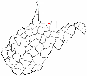
Brookhaven is a census-designated place (CDP) in Monongalia County, West Virginia, United States. The population was 5,707 at the 2020 census. It is included in the Morgantown, West Virginia Metropolitan Statistical Area.
South Park is a census-designated place (CDP) in Teton County, Wyoming, United States. The population was 1,831 at the 2010 census. It is part of the Jackson, WY–ID Micropolitan Statistical Area. The community does not have any connections with South Park, the animated Comedy Central television series.
Hollins is a census-designated place (CDP) in Botetourt and Roanoke counties in the U.S. state of Virginia. Hollins covers much of the area known locally as "North County". The population was 15,574 at the 2020 census. It is part of the Roanoke Metropolitan Statistical Area. The area is also the home of Hollins University in addition to four properties listed on the National Register of Historic Places: the Black Horse Tavern-Bellvue Hotel and Office, Harshbarger House, the Hollins College Quadrangle, and Old Tombstone.

