
Garrett County (gərɛt) is the westernmost county of the U.S. state of Maryland. As of the 2010 census, the population was 30,097, making it the third-least populous county in Maryland. Its county seat is Oakland. The county was named for John Work Garrett (1820–1884), president of the Baltimore and Ohio Railroad. Created from Allegany County, Maryland in 1872, it was the last Maryland county to be formed.
Covington is an independent city in the Commonwealth of Virginia. As of the 2010 census, the population was 5,961, making it the third-least populous city in Virginia. It is surrounded by Alleghany County, of which it is also the county seat. Located at the confluence of Jackson River and Dunlap Creek, Covington is one of three cities in the Roanoke Regional Partnership. The Bureau of Economic Analysis combines the city of Covington with Alleghany county for statistical purposes.

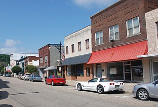
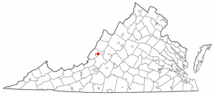
Clifton Forge is a town in Alleghany County, Virginia, United States which is part of the Roanoke Region. The population was 3,884 at the 2010 census. The Jackson River flows through the town, which as a result was once known as Jackson's River Station.

Iron Gate is a town in Alleghany County, Virginia, United States. The population was 388 at the 2010 census.
Low Moor is a census-designated place (CDP) in Alleghany County, Virginia. The population was 258 at the 2010 census.

Boones Mill is a town in Franklin County, Virginia, United States. The population was 239 at the 2010 census, down from 285 at the 2000 census. It is part of the Roanoke Metropolitan Statistical Area.
Ronceverte is a city in Greenbrier County, West Virginia, United States, on the Greenbrier River. The population was 1,765 at the 2010 census.

The Metropolitan Borough of Rotherham is a metropolitan borough of South Yorkshire, England. It is named after its largest town, Rotherham, but also spans the outlying towns of Maltby, Rawmarsh, Swinton, Wath-upon-Dearne, and also Dinnington and Laughton
as well as a suburban and rural element composed of hills, escarpments and broad valleys.

Niagara Centre is a federal electoral district in the Niagara Region of Ontario that has been represented in the House of Commons of Canada from 1867 to 1988 and since 1997.

Clifton Moor railway station was situated in England on the Eden Valley Railway between Penrith and Kirkby Stephen East. It served the village of Clifton. The station opened to passenger traffic on 1 August 1863, and was originally named 'Clifton'. The 'Moor' suffix was added on 1 September 1927. The station finally closed on 22 January 1962.
Greenwood Mountain is the name of several mountain summits in the United States.
Wildwood is a neighborhood in eastern Roanoke, Virginia, in the United States. It lies along U.S. 460 and is bordered by the neighborhoods of Hollins on the west, Mecca Gardens on the east, Eastgate on the north, and the town of Vinton to the south. Originally included as part of Roanoke County, Wildwood was annexed by the city in 1976. Predominantly rural prior to its annexation, growth within the neighborhood has been suburban in nature since the 1970s with significant commercial development located along its Orange Avenue frontage.
Kenwood is a Roanoke, Virginia neighborhood located in southeast Roanoke, along the north bank of the Roanoke River. It borders the neighborhoods of Morningside on the west, Fallon on the north, Riverdale on the south and the Town of Vinton on the east. The neighborhood is predominantly residential in character with the bulk of commercial development built along its Virginia State Route 24 frontage. Its development patterns typical of those experienced for an American city during the early 20th century.

Dabney S. Lancaster Community College (DSLCC) is a community college in Clifton Forge, Virginia, which is among the 23 public community colleges in the Virginia Community College System. It is named after Dr. Dabney S. Lancaster, an educator who served as Virginia's Superintendent of Public Instruction, and as president of Longwood College before retiring to Bath County.

Fort Spring is an unincorporated community and coal town in Greenbrier County, West Virginia, USA. It is situated along the Greenbrier River within the Greenbrier River Watershed. It was once a substantial portion of the Chesapeake and Ohio railway by way of the Gravel Girtie route from Hinton in Summers County, West Virginia to Clifton Forge in Virginia. The name comes from its main export; Mississippian limestone from Snowflake Quarry sent to Clifton Forge, Virginia The main road going through the small town was once the original rail line, but was moved.
West Fork is an unincorporated community in Pittsylvania County, in the U.S. state of Virginia.
Niagara West is a federal electoral district in Ontario. It encompasses a portion of Ontario formerly included in the electoral districts of Niagara West—Glanbrook, Welland and St. Catharines. It is currently represented by Dean Allison.
Gladesville is an unincorporated community in Preston County, in the U.S. state of West Virginia.
Valley Forge is an extinct town in St. Francois County, in the U.S. state of Missouri.


