Related Research Articles

Clifton Forge is a town in Alleghany County, Virginia, United States which is part of the greater Roanoke Region. The population was 3,555 at the 2020 census. The Jackson River flows through the town, which as a result was once known as Jackson's River Station.

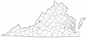
Iron Gate is a town in eastern Alleghany County, Virginia, United States. The population was 324 at the 2020 census. The town is located along U.S. Route 220, near Clifton Forge.
Low Moor is a census-designated place (CDP) in Alleghany County, Virginia. The population was 258 at the 2010 census.

Selma is a census-designated place (CDP) in Alleghany County, Virginia, United States. The population was 529 at the 2010 census.

Madison Heights is a census-designated place (CDP) in Amherst County, Virginia, United States. The population was 10,893 at the 2020 census. It is part of the Lynchburg Metropolitan Statistical Area.

Greenville is a census-designated place (CDP) in Augusta County, Virginia, United States. The population was 832 at the 2010 census. It is part of the Staunton–Waynesboro Micropolitan Statistical Area.

Forest is a census-designated place (CDP) in eastern Bedford County, Virginia, United States. The population was 11,709 at the 2020 census. It is part of the Lynchburg Metropolitan Statistical Area.
Daleville is a census-designated place (CDP) in Botetourt County, Virginia, United States. The population was 2,557 as of the 2010 census, an increase of over 75% from the 2000 census, when the population was 1,454. It is part of the Roanoke Metropolitan Statistical Area. One of the county's two high schools, Lord Botetourt, is located in Daleville.
Laymantown is a census-designated place (CDP) in southern Botetourt County, Virginia, United States. The population was 1,867 at the 2020 census. The community is located along State Route 658. It is part of the Roanoke Metropolitan Statistical Area.
Rustburg is a census-designated place (CDP) in and the county seat of Campbell County, Virginia, United States. The population was 1,431 at the 2010 census. It is part of the Lynchburg Metropolitan Statistical Area.

East Highland Park is a census-designated place (CDP) in Henrico County, Virginia, in the United States. The population was 15,131 at the 2020 census.

Fairlea is a census-designated place (CDP) in Greenbrier County, West Virginia, United States. The population was 1,747 at the 2010 census. Fairlea is the location of the annual West Virginia State Fair, held in August.

Stanaford is a census-designated place (CDP) and coal town in Raleigh County, West Virginia, United States. The population was 1,350 at the 2010 census.
Hollins is a census-designated place (CDP) in Botetourt and Roanoke counties in the U.S. state of Virginia. Hollins covers much of the area known locally as "North County". The population was 15,574 at the 2020 census. It is part of the Roanoke Metropolitan Statistical Area. The area is also the home of Hollins University in addition to four properties listed on the National Register of Historic Places: the Black Horse Tavern-Bellvue Hotel and Office, Harshbarger House, the Hollins College Quadrangle, and Old Tombstone.
Sussex is a census-designated place (CDP) in and the county seat of Sussex County, Virginia, United States. The population as of the 2020 Census was 181.

New Kent is a census-designated place (CDP) in and the county seat of New Kent County, Virginia, United States. The population as of the 2020 Census was 739.

Eagle Rock is a census-designated place (CDP) in Botetourt County, Virginia, United States, located along the James River between Iron Gate and Buchanan. It was first listed as a CDP in the 2020 census with a population of 209.
Mallow is an unincorporated community and census-designated place in Alleghany County, Virginia, United States. It was first listed as a CDP in the 2020 census with a population of 671.
Glen Wilton is a census-designated place (CDP) in northern Botetourt County, Virginia, United States. The population was 129 at the 2020 census. The CDP is located along the James River, between Eagle Rock and Iron Gate. It is part of the Roanoke Metropolitan Statistical Area.
Motley is a census-designated place (CDP) in Pittsylvania County, Virginia, United States. It was named for a notable Virginia family in colonial times, the Motleys. Two of them, Joseph and his son David James Motley, fought in the American Revolution. The population as of the 2010 Census was 1,015.
References
- ↑ U.S. Geological Survey Geographic Names Information System: Cliftondale Park, Virginia
- ↑ "Cliftondale Park CDP, Virginia". United States Census Bureau . Retrieved September 16, 2022.
Municipalities and communities of Alleghany County, Virginia, United States | ||
|---|---|---|
| Towns |  | |
| CDPs | ||
| Other communities |
| |
Coordinates: 37°49′24″N79°47′55″W / 37.82333°N 79.79861°W
| | This Alleghany County, Virginia state location article is a stub. You can help Wikipedia by expanding it. |