Covington is an independent city in the Commonwealth of Virginia. As of the 2020 census, the population was 5,737, making it the second-least populous city in Virginia. It is surrounded by Alleghany County, of which it is also the county seat. Located at the confluence of Jackson River and Dunlap Creek, Covington is one of three cities in the Roanoke Regional Partnership. The Bureau of Economic Analysis combines the city of Covington with Alleghany county for statistical purposes.

Clifton Forge is a town in Alleghany County, Virginia, United States which is part of the greater Roanoke Region. The population was 3,555 at the 2020 census. The Jackson River flows through the town, which as a result was once known as Jackson's River Station.

Botetourt County is a US county that lies in the Roanoke Region of the Commonwealth of Virginia. Located in the mountainous portion of the state, the county is bordered by two major ranges, the Blue Ridge Mountains and the Appalachian Mountains.

Bath County is a United States county on the central western border of the Commonwealth of Virginia, on the West Virginia state line. As of the 2020 census, the population was 4,209, the second-least populous county in Virginia. Bath's county seat is Warm Springs.

Alleghany County is an American county located on the far western edge of Commonwealth of Virginia. It is bordered by the Allegheny Mountains, from which the county derives its name, and it is the northernmost part of the Roanoke Region. The county seat is Covington. As of the 2020 census, the population was 15,223.

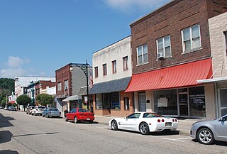
Selma is a census-designated place (CDP) in Alleghany County, Virginia, United States. The population was 529 at the 2010 census.

Goshen is a town in Rockbridge County, Virginia, United States. The population was 361 in the 2010 census.

The Virginia State Capitol is the seat of state government of the Commonwealth of Virginia, located in Richmond, the third capital city of the U.S. state of Virginia. It houses the oldest elected legislative body in North America, the Virginia General Assembly, first established as the House of Burgesses in 1619.

Buildings, sites, districts, and objects in Virginia listed on the National Register of Historic Places:
Belmont is a Roanoke, Virginia neighborhood located in southeast Roanoke. It borders the neighborhoods of Hollins and Williamson Road on the north, Morningside and South Jefferson to the south, Downtown on the west and Fallon on the east. Today the neighborhood is bisected by Virginia State Route 24 and is bordered by Interstate 581 to the west.

Eagle Rock is a census-designated place (CDP) in Botetourt County, Virginia, United States, located along the James River between Iron Gate and Buchanan. It was first listed as a CDP in the 2020 census with a population of 209.
Callaghan is an Unincorporated community and census-designated place (CDP) in Alleghany County, Virginia, United States. The population as of the 2010 Census was 348.
Sweet Chalybeate is an unincorporated community in Alleghany County, Virginia, United States. It is located directly across the state-line from Sweet Springs, West Virginia. It is serviced by Virginia State Route 311.

Tyro is an unincorporated community in Nelson County, Virginia, United States. It was among the communities severely affected by flash flooding from Hurricane Camille in 1969.

Carpenter Creek in western Virginia, now known as Potts Creek, was shown on a map of the area drawn by Joshua Fry and Peter Jefferson in 1751 and printed in 1755, and so called in the text of Thomas Jefferson's "Notes on the State of Virginia" that he prepared in the 1780s. Carpenter's Creek is also shown as such on John Ballendine's map of the James River published c1772 and Thomas Hutchins' map of the western regions of Virginia published in 1778.

Millboro Springs is an unincorporated community in Bath County, Virginia, in the United States.
Cascade is an unincorporated community in Pittsylvania County, in the U.S. state of Virginia.

Massie House, also known as Oak Grove, was a historic home located at Falling Spring, Alleghany County, Virginia. It was built in two phases in 1825–1826, and was a double-pile, two-story, five bay, wood-frame house on a brick foundation in the Federal style. The main entrance featured the original paneled double-doors ornamented with small Chinese and Gothic motifs, flanked by sidelights and topped by a segmental fanlight.

