Related Research Articles

Dublin is a town in Jackson Township, Wayne County, in the U.S. state of Indiana. The population was 679 at the 2020 census.

Pulaski is a town in Pulaski County, Virginia, United States. The population was 9,086 at the 2010 census. It is the county seat of Pulaski County.

Tazewell is a town in Tazewell County, Virginia, United States. The population was 4,627 at the 2010 census. It is part of the Bluefield, WV-VA micropolitan area, which has a population of 107,578. It is the county seat of Tazewell County.
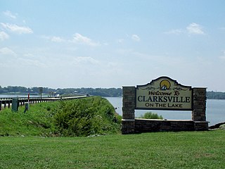
Clarksville is a town in Mecklenburg county in the U.S. state of Virginia, near the southern border of the commonwealth. The population was 1,139 at the 2010 census. Since the town has numerous buildings of the 18th-, 19th-, and early 20th-century architecture, the downtown area of Clarksville has been designated a Historic District on the National Register of Historic Places and Virginia's Historic Register. Clarksville claims the title of Virginia's only Lakeside town. Nearby the town of Clarksville is Occoneechee State Park.
Sussex is a census-designated place (CDP) in and the county seat of Sussex County, Virginia, United States. The population as of the 2020 Census was 181.

Nottoway, or Nottoway Court House, is a census-designated place (CDP) in and the county seat of Nottoway County, Virginia, United States. The population as of the 2010 Census was 84.

Prince George is a census-designated place (CDP) in and the county seat of Prince George County, Virginia, United States. The population as of the 2010 Census was 2,066. It is in the metro area of Richmond, Virginia. The elevation is at 131 feet.
Nellysford is a census-designated place (CDP) in Nelson County, Virginia, United States. The population as of the 2010 Census was 1,076. It is home to the Wintergreen golf course at Stoney Creek. Its zip code is 22958.
Lafayette is a census-designated place (CDP) between the cities of Roanoke and Christiansburg in eastern Montgomery County, southwest Virginia, United States. The population as of the 2010 Census was 449. It is located adjacent to Elliston, at the confluence of the North and South Forks of the Roanoke River.

Seven Mile Ford is a census-designated place (CDP) in Smyth County, Virginia, United States. The population as of the 2010 Census was 783. It obtained its current name as a result of being a river crossing seven miles from the Royal Oak Fort in Marion, Virginia. U.S. Hwy 11 passes through the center of the community, which is approximately 4 miles (6.4 km) from Chilhowie.

Franktown is an unincorporated community and census-designated place in Northampton County, Virginia, United States. It was first listed as a CDP in the 2020 census with a population of 61.
Arrington is a census-designated place (CDP) in Nelson County, Virginia, United States. The population as of the 2010 Census was 708. Harmony Hill Bed and Breakfast is the only lodging location in Arrington, run by innkeepers Wendie and Jay Fines.
Shipman is a census-designated place (CDP) in Nelson County, Virginia, United States. The population as of the 2010 Census was 507.
Wintergreen is a census-designated place (CDP) in Augusta and Nelson counties, Virginia, United States, located near Wintergreen Resort. The population as of the 2010 Census was 165.
Wicomico Church is an unincorporated community in Northumberland County, in the U.S. state of Virginia.
Oak Corner is an unincorporated community in Caroline County, in the U.S. state of Virginia.

Belspring is a census-designated place (CDP) in Pulaski County, Virginia, United States, located at an elevation of 1,778 feet (542 m) above sea level. It has the ZIP Code 24058 and the area code 540. The population of the CDP was 256 at the 2010 Census.
Naxera is an unincorporated community in Gloucester County, in the U. S. state of Virginia.

Wicomico is an unincorporated community in Gloucester County, in the U. S. state of Virginia.
Zanoni is an unincorporated community in Gloucester County, in the U. S. state of Virginia.
