Smithfield, South Africa

Last updated
Smithfield
Smithfield stadsaal.jpg
Smithfield Town Hall
South Africa Free State location map.svg
Red pog.svg
Smithfield
South Africa adm location map.svg
Red pog.svg
Smithfield
Africa location map.svg
Red pog.svg
Smithfield
Coordinates: 30°12′45″S26°31′53″E / 30.21250°S 26.53139°E / -30.21250; 26.53139
Country South Africa
Province Free State
District Xhariep
Municipality Mohokare
Established1849 [1]
Area
[2]
  Total35.5 km2 (13.7 sq mi)
Population
 (2011) [2]
  Total4,779
  Density130/km2 (350/sq mi)
Racial makeup (2011)
[2]
   Black African 91.4%
   Coloured 5.0%
   Indian/Asian 0.3%
   White 3.1%
  Other0.3%
First languages (2011)
[2]
   Sotho 66.9%
   Xhosa 20.9%
   Afrikaans 8.4%
   English 1.3%
  Other2.4%
Time zone UTC+2 (SAST)
Postal code (street)
9966
PO box
9966
Area code 051

Smithfield is a small town in the Free State province of South Africa. Founded in 1848 in the Orange River Sovereignty (as the region was then named), the town is situated in a rural farming district and is the third oldest town in present-day Free State, after Philippolis and Winburg.

Contents

History

Land disputes

From the 1830s onwards, numbers of white settlers from the Cape Colony crossed the Orange River and started arriving in the fertile southern part of territory known as the Lower Caledon Valley, in which the commonage of Smithfield would later be established. The Lower Caledon Valley, named after the Caledon River that runs through it, was at that time occupied by herders and their cattle under the authority of the Basotho king Moshoeshoe. In 1845, a treaty was signed between Moshoeshoe and the British colonial authorities headed by the Cape Colony governor Sir Harry Smith. The treaty recognised white occupation in the area, though no boundaries were stipulated.

In early South Africa, European notions of boundaries and private land ownership had no counterparts in African political culture. To the local African chieftains, customary tribute in the form of horses and cattle represented acceptance by the reigning chief of land use under his authority. To both the Boer and the British settlers, the same form of tribute was believed to constitute purchase and permanent ownership of the land under independent authority. [3] [4] :48–9

King Moshoeshoe with his advisors King Moshoeshoe of the Basotho with his ministers.jpg
King Moshoeshoe with his advisors

According to historical accounts, Moshoeshoe was under the impression he was authorising temporary grazing land to the settlers, while the settlers believed they had been given permanent land rights. Conflicts ensued. The British, who at that time had taken control of the area between the Orange and Vaal Rivers, which they named the Orange River Sovereignty, decided a discernible boundary was necessary and proclaimed a line known as the Warden Line, which divided the area between British and Basotho territories. Smithfield was placed within the British territory and became the colonial administrative centre of what was named the Caledon District. The Mohokare river, meaning "in the midst" (of Basotho territory), which ran close to Smithfield, was renamed the Caledon river, after the Earl of Caledon, British governor of the Cape Colony from 1807 to 1811.

Although land in the district belonged officially to the British Crown, the British civil commissioner of Smithfield, Charles Halse, made a personal fortune speculating in private land deals. [4] In 1854, the British handed over the territory to the Boer republic of Orange Free State, formalised with the signing of the Orange River Convention. [5]

A succession of wars followed from 1858 to 1868 between the Basotho kingdom and the Boer republic of Orange Free State. [6] Both sides adopted scorched-earth tactics. In particular, the Basotho destroyed farmhouses and burned large swathes of pasturage and cropland in the area between Smithfield and Reddersburg. [7] The Boer commandos, for their part, attacked and destroyed the French Evangelical Mission station at Beersheba, near Smithfield, which the Boers considered to be sympathetic towards the Basotho.

Establishment

Waterval farm was the original site chosen in 1848 for settlement as a Dutch Reformed (NG) church centre. However, when plots were offered for sale, there were no takers. Farmers were dissatisfied with the site (24 km west of present-day Smithfield). They then opted for Rietpoort, where there was abundant water. The new town was named New Smithfield (the "New" soon fell away), apparently named after Sir Harry Smith, former governor of the Cape Colony (from 1847-1852). In the fifty years after the town was established, the Dutch Reformed Church remained a central point of the town. one of the dominees who served there was Rev Andrew Murray.The Second Boer War General Christiaan de Wet was born on the nearby farm Leeukop in 1854.

Smithfield had a village board in 1860 but only became a municipality in 1948. In the 1870s the town was on one of the main routes to the Diamond Fields from the coast via Aliwal North, and trade was brisk in that period.

In the period 1907 to 1939, the MP for Smithfield was General Hertzog who represented the constituency for the Oranje Unie, the South African Party, the National Party and the United Party. He was the leader of the National Party from 1914 to 1939 and Prime Minister of SA from 1924 to 1929.

On 19 August 1960, Prime Minister HF Verwoerd addressed a conference in Smithfield, where he announced plans to withdraw from the British Commonwealth and to unilaterally declare a Republic. He added that "South Africa is destined to be the country that will provide Whites all over the world with a new source of inspiration." His announcement from Smithfield made international news headlines. [8]

Geographic setting

The town is tucked into a horseshoe of hills, some 132 km southeast of Bloemfontein along the N6 national road to East London, Eastern Cape. The Caledon River bounds Smithfield on the east and south. The district is drained by various tributaries of this river, the Vinkel and Wilgeboom Spruits being the largest. As the town lies 13 km west of the river, water has to be obtained from boreholes around the town dam.

Demographics and economy

Smithfield is part of the impoverished Xhariep district. [9] It has a population of approximately 4,000 black people, and a white population of about 500. The generally run-down condition of the town is contrasted by the comparative prosperity of the surrounding wool-growing and cattle farming district.

Administration

Smithfield is one of three towns within the municipal jurisdiction of Mohokare Local Municipality. As a result of a municipal debt crisis, the municipality is unable to provide satisfactory basic services to its residents. These include sanitation, water, town planning and road repairs. [10]

Accommodation

The town's position astride major tourist routes has lent some impetus to tourism. Smithfield hosts nine guest-houses and bed and breakfast establishments. [11]

Places of interest

The Caledon River museum is located in the town. The Carmel and Beersheba missionary posts are situated nearby. The well-maintained local golf course dates back more than 100 years. Its facilities are open to guests, as are local tennis court and bowls club. Hills surrounding the town are considered well-suited to hiking, horse-riding and bird-watching in relative isolation. Local secondary roads and mountain trails are suitable for mountain biking. Blesbok and some Zebra are to be found in the open savanna [12] Game farms such as Letatsi is also found 25 km outside of Smithfiled, which enhances the experiences of seeing wildlife up close in game drives and also being able to do hunting in the hunting season which is normally between June–August. [13]

Archaeology

The Wilton/Smithfield fossil classification system takes its name in part from the town. Scientist George Stow excavated a cave near Smithfield in 1877 and found tools from the Late Stone Age which he described in his book, Native races of South Africa. [14] Bushman paintings are present in nearby hills.

Related Research Articles

<span class="mw-page-title-main">Lesotho</span> Country in Southern Africa, within the border of South Africa

Lesotho, formally the Kingdom of Lesotho, is a landlocked country in Southern Africa. As an enclave of South Africa, with which it shares a 1,106 km border, it is the only sovereign enclave in the world outside of the Italian Peninsula. It is situated in the Maloti Mountains and contains the highest peak in Southern Africa. It has an area of over 30,000 km2 (11,600 sq mi) and has a population of about 2 million. Its capital and largest city is Maseru.

<span class="mw-page-title-main">History of Lesotho</span> Historical development of Lesotho

The history of people living in the area now known as Lesotho goes back as many as 400 years. Present Lesotho emerged as a single polity under King Moshoeshoe I in 1822. Under Moshoeshoe I, Basotho joined other clans in their struggle against the Lifaqane associated with famine and the reign of Shaka Zulu from 1818 to 1828.

<span class="mw-page-title-main">Maseru</span> Capital and largest city of Lesotho

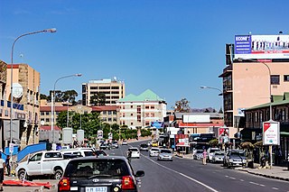
Maseru is the capital and largest city of Lesotho. It is also the capital of the Maseru District. Located on the Caledon River, Maseru lies directly on the Lesotho–South Africa border. Maseru had a population of 330,760 in the 2016 census. The city was established as a police camp and assigned as the capital after the country became a British protectorate in 1869. When the country achieved independence in 1966, Maseru retained its status as capital. The name of the city is a Sesotho word meaning "red sandstones".

<span class="mw-page-title-main">Basutoland</span> British colony from 1884 to 1966

Basutoland was a British Crown colony that existed from 1884 to 1966 in present-day Lesotho, bordered with the Cape Colony, Natal Colony and Orange River Colony until 1910 and completely surrounded by South Africa from 1910. Though the Basotho and their territory had been under British control starting in 1868, the Cape Colony was unpopular and unable to control the territory. As a result, Basutoland was brought under direct authority of Queen Victoria, via the High Commissioner, and run by an Executive Council presided over by a series of British Resident Commissioners.

<span class="mw-page-title-main">Orange Free State</span> 1854–1902 Boer republic in Southern Africa

The Orange Free State was an independent Boer sovereign republic under British suzerainty in Southern Africa during the second half of the 19th century, which ceased to exist after it was defeated and surrendered to the British Empire at the end of the Second Boer War in 1902. It is one of the three historical precursors to the present-day Free State province.

<span class="mw-page-title-main">Sotho people</span> Bantu ethnic group of Southern Africa

The Sotho, also known as the Basotho, are a prominent Sotho-Tswana ethnic group with roots in Southern Africa. They primarily inhabit the regions of Lesotho and South Africa.

<span class="mw-page-title-main">Moshoeshoe I</span> First King of Lesotho

Moshoeshoe I was the first king of Lesotho. He was the first son of Mokhachane, a minor chief of the Bamokoteli lineage, a branch of the Koena (crocodile) clan. In his youth, he helped his father gain power over some other smaller clans. At the age of 34 Moshoeshoe formed his own clan and became a chief. He and his followers settled at the Butha-Buthe Mountain. He became the first and longest-serving King of Lesotho in 1822.

<span class="mw-page-title-main">Wepener</span> Town near Lesotho in Free State, SA

Wepener is a town in the Free State, South Africa, located near the border of Lesotho.

<span class="mw-page-title-main">Free State–Basotho Wars</span> 1858–1868 series of Boer Wars in Southern Africa

The Free State–Basotho Wars refers to a series of wars fought between King Moshoeshoe I, the ruler of the Basotho Kingdom, and white settlers, in what is now known as the Free State. These can be divided into the Senekal's War of 1858, the Seqiti War in 1865−1866 and the Third Basotho War in 1867−68.

<span class="mw-page-title-main">Teyateyaneng</span> Town in Lesotho

Teyateyaneng is a town located in the district of Berea in Lesotho. Usually abbreviated to T.Y., Teyateyaneng takes its name from the two twin rivers which run on the north and the South. Both rivers lead to the Mohokare, or the Caledon River which forms the western boundary with South Africa. They are both named for their vast quantities of sand which means rapid dipping of feet as one crosses them, leading to both names which may well suggest that this is a 'place of quick sands'. Teyateyaneng's name therefore comes from the southern Teja-tejana River, but the name later changed to Teyateyaneng, perhaps due to British influences as the country became a Protectorate in the late 1800s.

The Orange River Convention was a convention whereby the British formally recognised the independence of the Boers in the area between the Orange and Vaal rivers, which had previously been known as the Orange River Sovereignty. This resulted in the formation of the independent Boer Republic of the Orange Free State (OFS).

<span class="mw-page-title-main">History of South Africa (1815–1910)</span> Formation of the Nation of South Africa

During the Napoleonic Wars, the Cape Colony was annexed by the British and officially became their colony in 1815. Britain encouraged settlers to the Cape, and in particular, sponsored the 1820 Settlers to farm in the disputed area between the colony and the Xhosa in what is now the Eastern Cape. The changing image of the Cape from Dutch to British excluded the Dutch farmers in the area, the Boers who in the 1820s started their Great Trek to the northern areas of modern South Africa. This period also marked the rise in power of the Zulu under their king Shaka Zulu. Subsequently, several conflicts arose between the British, Boers and Zulus, which led to the Zulu defeat and the ultimate Boer defeat in the Second Anglo-Boer War. However, the Treaty of Vereeniging established the framework of South African limited independence as the Union of South Africa.

<span class="mw-page-title-main">Thaba Bosiu</span>

Thaba Bosiu is a constituency and sandstone plateau with an area of approximately 2 km2 (0.77 sq mi) and a height of 1,804 meters above sea level. It is located between the Orange and Caledon Rivers in the Maseru District of Lesotho, 24 km east of the country's capital Maseru. It was once the capital of Lesotho, having been King Moshoeshoe's stronghold.

<span class="mw-page-title-main">Lesotho–South Africa border</span> International border

The border between Lesotho and South Africa is 909 kilometres (565 mi) long and forms a complete loop, as Lesotho is an enclave entirely surrounded by South Africa. The border follows the Caledon River, the drainage divide of the Drakensberg mountains, the Orange River, the Makhaleng River, and a series of hills joining the Makhaleng back to the Caledon.

<span class="mw-page-title-main">Morosi</span>

Morosi was a Baphuthi chief in the wild southern part of Basutoland. He led a revolt against the Cape Colony government in 1879, in defence of his independence south of the Orange River. The British refused to help the Cape Government. However, Letsie, the paramount chief and first son of Moshoeshoe, and many of the Sotho ruling establishment, rallied to support the Cape forces, and the rebellion was put down after several months of arduous fighting. Morosi was beheaded and his body mutilated by Cape troops.

<span class="mw-page-title-main">Battle of Berea</span> 1852 battle between the Cape Colony and the Basuto people

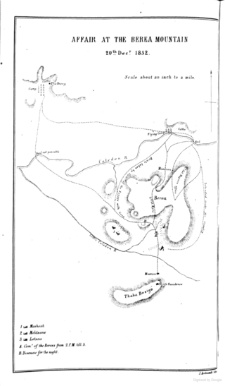
The Battle of Berea was a battle between British forces under Sir George Cathcart and Basuto-Taung forces under King Moshoeshoe I that took place on 20 December 1852. The battle began when British forces broke into three columns and crossed the Caledon River in southern Africa, with the goal of seizing Basuto cattle as a form of punishment for past Basuto cattle raiding.

The Battle of Naauwpoort Nek refers to a clash between the Trekboers and Basotho warriors on 29 September 1865. Naauwpoort lies immediately to the north of the Free State town of Clarens.

<span class="mw-page-title-main">Johan Fick</span>

General Johan Isak Jacobus Fick was the founder of Ficksburg, a town in the Free State province, South Africa. After the Basotho Wars, peace was made and the town named after Johan Fick. He was also known as Commandant Generaal Johan Fick.

<span class="mw-page-title-main">Basotho nationality law</span> Lesotho law governing nationality

Basotho nationality law is regulated by the Constitution of Lesotho, as amended; the Lesotho Citizenship Order, and its revisions; the 1983 Refugees Act; and various international agreements to which the country is a signatory. These laws determine who is, or is eligible to be, a national of Lesotho. The legal means to acquire nationality, formal legal membership in a nation, differ from the domestic relationship of rights and obligations between a national and the nation, known as citizenship. Nationality describes the relationship of an individual to the state under international law, whereas citizenship is the domestic relationship of an individual within the nation. In Britain and thus the Commonwealth of Nations, though the terms are often used synonymously outside of law, they are governed by different statutes and regulated by different authorities. Basotho nationality is typically obtained under the principle of jus soli, born in Lesotho, or jus sanguinis, i.e. by birth in Lesotho or abroad to parents with Basotho nationality. It can be granted to persons with an affiliation to the country, or to a permanent resident who has lived in the country for a given period of time through naturalisation.

<span class="mw-page-title-main">'Mantsopa</span> Basotho prophet (1793–1908)

'Mantsopa Anna Makhetha (1793–1908), often referred to as 'Mantsopa, was a Basotho prophetess, rainmaker, and storyteller. She advised King Moshoeshoe I and predicted the outcomes of several battles, including the Battle of Viervoet in 1851 and the Battle of Berea in 1852. She was exiled to Modderpoort in the late 1860s, where she converted to Christianity and was baptised in 1870. She fused Christianity with her own traditional Basotho customs.

References

  1. Robson, Linda Gillian (2011). "Annexure A" (PDF). The Royal Engineers and settlement planning in the Cape Colony 1806–1872: Approach, methodology and impact (PhD thesis). University of Pretoria. pp. xlv–lii. hdl:2263/26503.
  2. 1 2 3 4 Sum of the Main Places Smithfield and Mofulatshepe from Census 2011.
  3. Germond, Paul (1967). Chronicles of Basutoland. Morija (Lesotho): Morija Sesuto Books. pp. 144f, 252–53.
  4. 1 2 Eldredge, Elizabeth (2002). A South African Kingdom: The pursuit of security in 19th century Lesotho. Cambridge University Press.
  5. About Lesotho Archived 2013-04-13 at archive.today . Accessed 1 May 2015
  6. Beck, Roger B (2000). History of South Africa . Westport, Connecticut: Greenwood Press. p.  74. ISBN   9780313307300.
  7. Theal, George McCall (1919). "War with the Basuto". History of South Africa. Vol. IV. London: Allen & Unwin. pp. 225–79.
  8. Rand Daily Mail, 20 August 1960
  9. The Weekly, (Bloemfontein), "Magashule rebukes Mohokare over debt", November 18, 2011
  10. The Weekly, (Bloemfontein), November 18, 2011
  11. Accommodation in Smithfield
  12. "Interesting places and things to do in Smithfield". Grocotts Mail'. Grahamstown. 6 June 2014.
  13. Lonewolf (12 February 2019), Activities in and around Smithfield, Smithfield{{citation}}: CS1 maint: location missing publisher (link)
  14. Stow, George William (1905). The native races of South Africa: A history of the intrusion of the Hottentots and Bantu into the hunting grounds of the Bushmen, the aborigines of the country. London: Macmillan.