Springfield, Colorado | |
---|---|
Coordinates: 37°24′24″N102°37′2″W / 37.40667°N 102.61722°W | |
Country | United States |
State | Colorado |
County [1] | Baca [2] |
Settled | 1888 |
Incorporated | January 16, 1889 [3] |
Government | |
• Type | Statutory Town [1] |
Area | |
• Total | 1.13 sq mi (2.92 km2) |
• Land | 1.13 sq mi (2.92 km2) |
• Water | 0.00 sq mi (0.00 km2) |
Elevation | 4,360 ft (1,329 m) |
Population | |
• Total | 1,325 |
• Density | 1,200/sq mi (450/km2) |
Time zone | UTC-7 (Mountain (MST)) |
• Summer (DST) | UTC-6 (MDT) |
ZIP code [7] | 81073 |
Area code | 719 |
FIPS code | 08-73330 |
GNIS feature ID | 0203868 |
Website | www |
Springfield is a Statutory Town which is also the county seat and most populous town in Baca County, Colorado, United States. [8] The population was 1,325 at the 2020 census. [6]
The town was named after Springfield, Missouri. [9]
Frank and Jim Tipton settled in Las Animas, Colorado in 1886. In 1888 or 1889, the Tiptons secured the title to 80 acres which was the original townsite. They did this using a "soldiers script" and named the town after Springfield, Missouri, since this is where the Tipton brothers had come from. [10]
Springfield is located in north-central Baca County at 37°24′24″N102°37′2″W / 37.40667°N 102.61722°W (37.406629, -102.617243). [11] It is located approximately 30 miles north of the Oklahoma state line.
U.S. Routes 287 and 385 pass through the center of the town, leading north 47 miles (76 km) to Lamar, Colorado, and south 49 miles (79 km) to Boise City, Oklahoma. U.S. Route 160 passes just to the south of the town, leading west 120 miles (190 km) to Trinidad, Colorado, and east 50 miles (80 km) to Johnson City, Kansas.
Springfield Municipal Airport (FAA ID: 8V7) is four miles north. [12]
According to the United States Census Bureau, the town has a total area of 1.1 square miles (2.9 km2), all of it land. [13]
Springfield has a cool semi-arid climate (Köppen BSk) with hot summers featuring mild mornings and occasional heavy thunderstorm rains, and highly variable winters that range from very warm and windy to frigid and relatively still.
Climate data for Springfield 7 WSW, Colorado (1971 to 2000; extremes 1956 to 2001) | |||||||||||||
---|---|---|---|---|---|---|---|---|---|---|---|---|---|
Month | Jan | Feb | Mar | Apr | May | Jun | Jul | Aug | Sep | Oct | Nov | Dec | Year |
Record high °F (°C) | 79 (26) | 83 (28) | 90 (32) | 97 (36) | 104 (40) | 111 (44) | 109 (43) | 104 (40) | 101 (38) | 95 (35) | 86 (30) | 78 (26) | 111 (44) |
Mean daily maximum °F (°C) | 44.9 (7.2) | 50.1 (10.1) | 57.8 (14.3) | 66.3 (19.1) | 75.0 (23.9) | 86.3 (30.2) | 91.3 (32.9) | 88.8 (31.6) | 80.2 (26.8) | 69.7 (20.9) | 54.4 (12.4) | 45.3 (7.4) | 67.5 (19.7) |
Mean daily minimum °F (°C) | 14.9 (−9.5) | 18.4 (−7.6) | 24.1 (−4.4) | 32.7 (0.4) | 43.2 (6.2) | 54.2 (12.3) | 58.4 (14.7) | 57.4 (14.1) | 48.4 (9.1) | 36.8 (2.7) | 24.1 (−4.4) | 16.7 (−8.5) | 35.8 (2.1) |
Record low °F (°C) | −23 (−31) | −22 (−30) | −10 (−23) | 5 (−15) | 20 (−7) | 37 (3) | 44 (7) | 40 (4) | 21 (−6) | 6 (−14) | −11 (−24) | −18 (−28) | −23 (−31) |
Average precipitation inches (mm) | 0.47 (12) | 0.48 (12) | 1.16 (29) | 1.64 (42) | 2.86 (73) | 2.00 (51) | 2.49 (63) | 2.46 (62) | 1.37 (35) | 0.96 (24) | 0.73 (19) | 0.42 (11) | 17.04 (433) |
Average snowfall inches (cm) | 5.4 (14) | 4.4 (11) | 7.7 (20) | 3.3 (8.4) | 1.0 (2.5) | 0.0 (0.0) | 0.0 (0.0) | 0.0 (0.0) | 0.4 (1.0) | 1.8 (4.6) | 4.4 (11) | 5.1 (13) | 33.5 (85.5) |
Average precipitation days (≥ 0.01 inch) | 3.8 | 3.5 | 5.8 | 5.6 | 9.0 | 6.8 | 8.1 | 7.4 | 5.3 | 4.0 | 3.7 | 3.7 | 66.7 |
Average snowy days (≥ 0.1 inch) | 3.8 | 3.2 | 3.5 | 1.4 | 0.3 | 0.0 | 0.0 | 0.0 | 0.2 | 0.7 | 2.7 | 3.4 | 19.2 |
Source: NOAA [14] |
Census | Pop. | Note | %± |
---|---|---|---|
1920 | 295 | — | |
1930 | 1,393 | 372.2% | |
1940 | 1,082 | −22.3% | |
1950 | 2,131 | 97.0% | |
1960 | 1,791 | −16.0% | |
1970 | 1,660 | −7.3% | |
1980 | 1,657 | −0.2% | |
1990 | 1,475 | −11.0% | |
2000 | 1,562 | 5.9% | |
2010 | 1,451 | −7.1% | |
2020 | 1,325 | −8.7% | |
U.S. Decennial Census |
As of the census [15] of 2010, there were 1,451 people, 715 households, and 409 families residing in the town. The population density was 1,793.8 inhabitants per square mile (692.6/km2). There were 838 housing units at an average density of 962.4 per square mile (371.6/km2). The racial makeup of the town was 94.88% White, 1.15% Native American, 0.19% Asian, 2.56% from other races, and 1.22% from two or more races. Hispanic or Latino of any race were 5.83% of the population.
There were 715 households, out of which 23.1% had children under the age of 18 living with them, 44.8% were married couples living together, 9.9% had a female householder with no husband present, and 42.7% were non-families. 38.6% of all households were made up of individuals, and 20.6% had someone living alone who was 65 years of age or older. The average household size was 2.10 and the average family size was 2.80.
In the town, the population was spread out, with 21.4% under the age of 18, 6.7% from 18 to 24, 22.1% from 25 to 44, 23.7% from 45 to 64, and 26.2% who were 65 years of age or older. The median age was 45 years. For every 100 females, there were 88.9 males. For every 100 females age 18 and over, there were 86.3 males.
The median income for a household in the town was $28,099, and the median income for a family was $34,107. Males had a median income of $25,385 versus $16,339 for females. The per capita income for the town was $13,890. About 14.4% of families and 16.8% of the population were below the poverty line, including 18.6% of those under age 18 and 17.8% of those age 65 or over.
The Board of Trustees as of December 2020 consists of Tyler K Gibson (Mayor), Ervin Maltbie (Mayor Pro-Tem), and Trustees Ted Locke, Jim Howard, Mike Cooper, Dan McVey, and Christy Brady. [16] Town Clerk is Tammy Newman; Town Manager/Treasurer is Merna McGinnis. [17]
The superintendent, and elementary principal, is Richard Hargrove, and the high school principal is Ginger Walker. The town has one library.
Notable individuals who were born in or have lived in Springfield include:
The Town of Crestone is a Statutory Town in Saguache County, Colorado. According to the 2020 United States Census, the town's population was 141. Crestone is located at the foot of the western slope of the Sangre de Cristo Range, in the northern part of the San Luis Valley. Crestone was platted in 1880 by George Adams, owner of the neighboring Luis Maria Baca Grant No. 4. In the 1970s, the Baca Grande land development was established on the lands of the Baca Grant to the south and west. Several hundred homes have been built there.
Yuma County is a county located in the U.S. state of Colorado. As of the 2020 census, the population was 9,988. The county seat is Wray.
Sedgwick County is a county located in the U.S. state of Colorado. As of the 2020 census, the population was 2,404. The county seat is Julesburg. The county was named for Fort Sedgwick, a military post along the Platte Trail, which was named for General John Sedgwick. It is located near the state border with Nebraska.
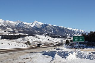
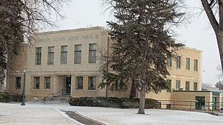
Saguache County is a county located in the U.S. state of Colorado. As of the 2020 census, the population was 6,368. The county seat is Saguache.
Prowers County is a county located in the U.S. state of Colorado. As of the 2020 census, the population was 11,999. The county seat is Lamar. The county is named in honor of John Wesley Prowers, a leading pioneer in the lower Arkansas River valley region.
Kit Carson County is a county located in the U.S. state of Colorado. As of the 2020 census, the population was 7,087. The county seat is Burlington. The county was established in 1889 and named for American frontiersman and Indian fighter Kit Carson.
Bent County is a county located in the U.S. state of Colorado. As of the 2020 census, the population was 5,650. The county seat and only incorporated municipality is Las Animas. The county is named in honor of frontier trader William Bent.
Baca County is a county located in the U.S. state of Colorado. As of the 2020 census, the population was 3,506. The county seat is Springfield. Located at the southeast corner of Colorado, the county shares state borders with Kansas, New Mexico, and Oklahoma.
Sherrelwood is an unincorporated community and a census-designated place (CDP) located in and governed by Adams County, Colorado, United States. The CDP is a part of the Denver–Aurora–Lakewood, CO Metropolitan Statistical Area. The population was 19,228 at the 2020 census.
Campo is a Statutory Town located in Baca County, Colorado, United States. The town population was 103 at the 2020 United States Census. The town is situated on the High Plains, straddling U.S. Route 287/385.
Cheyenne Wells is the Statutory Town that is the county seat and the most populous municipality of Cheyenne County, Colorado, United States. The town population was 758 at the 2020 United States Census.
Eads is the Statutory Town that is the county seat and the most populous municipality of Kiowa County, Colorado, United States. The town population was 672 at the 2020 United States Census.
Bethune is a Statutory Town located in Kit Carson County, Colorado, United States. The town population was 183 at the 2020 United States Census. It is located along U.S. Highway 24 that is north of an exit on Interstate 70.
The Town of Fleming is a Statutory Town in Logan County, Colorado, United States. The town population was 428 at the 2020 United States Census. Fleming is a part of the Sterling, CO Micropolitan Statistical Area.
Holyoke is the home rule municipality that is the county seat and the most populous municipality of Phillips County, Colorado, United States. The city population was 2,346 at the 2020 United States Census.
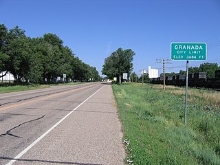
Granada is a Statutory Town in Prowers County, Colorado, United States. The town population was 445 at the 2020 United States Census.
Wiley is a Statutory Town in Prowers County, Colorado, United States. The population was 437 at the 2020 Census.
Eckley is a statutory town located in Yuma County, Colorado, United States. The town population was 232 at the 2020 United States Census.
Tipton (/ˈtɪptən/) is a city in Cedar County, Iowa, United States. The population was 3,149 at the time of the 2020 census. It is the county seat of Cedar County.
Paint Township is a township in Clarion County, Pennsylvania, United States. The population was 1,645 at the 2020 census, a decrease from the figure of 1,699 tabulated in 2010.