Hugo, Colorado

Last updated

Hugo, Colorado
Hugo, Colorado downtown 1.JPG
Downtown Hugo, looking northwest along U.S. Highway 40.
Lincoln County Colorado Incorporated and Unincorporated areas Hugo Highlighted 0837875.svg
Location of Hugo in Lincoln County, Colorado.
Coordinates: 39°8′1″N103°28′5″W / 39.13361°N 103.46806°W / 39.13361; -103.46806
Country Flag of the United States (23px).png  United States
State Flag of Colorado.svg  State of Colorado
County Lincoln County Seat [1]
Incorporated June 21, 1909 [2]
Government
  Type Statutory Town [1]
  MayorLora Bledsoe
Area
[3]
  Total0.91 sq mi (2.36 km2)
  Land0.91 sq mi (2.36 km2)
  Water0.00 sq mi (0.00 km2)
Elevation
[4]
5,039 ft (1,536 m)
Population
 (2020) [5]
  Total787
  Density860/sq mi (330/km2)
Time zone UTC-7 (Mountain (MST))
  Summer (DST) UTC-6 (MDT)
ZIP code [6]
80821
Area code 719
FIPS code 08-37875
GNIS feature ID 195141
Website City Website

Hugo is a statutory town in and the county seat of Lincoln County, Colorado, United States. [7] The town population was 787 at the 2020 census. [5]

Contents

History

In about 1859 the town was developed as a cattle ranching community to supply miners with provisions. The town was also used as a local stage coach stop. [8]

There are two stories as to how the town obtained its name. One version says the town was named by the Kansas Pacific Railroad builders after pioneer stage agent (Overland company), Hugo Richards. Richards later moved to Prescott, Arizona where he became town banker and businessman. [9] [10] Another story says the town was named for Richard Hugo who was a local settler. [11] The town was founded in 1870, [12] and incorporated in 1909. [13]

In July 2016, the water supply for the town of Hugo was purportedly contaminated by THC, the main psychoactive component in cannabis. [14] Subsequent testing found no THC in the water supply, and authorities believe the initial tests were false positives. [15]

Geography

According to the United States Census Bureau, the town has a total area of 1.0 square mile (2.6 km2), all of which is land. Hugo's elevation is 5,039 ft.

Climate

According to the Köppen Climate Classification system, Hugo has a cold semi-arid climate, abbreviated "BSk" on climate maps.

Climate data for Hugo, Colorado, 19912020 normals, extremes 18972019
MonthJanFebMarAprMayJunJulAugSepOctNovDecYear
Record high °F (°C)78
(26)
82
(28)
85
(29)
89
(32)
98
(37)
103
(39)
104
(40)
101
(38)
100
(38)
91
(33)
83
(28)
75
(24)
104
(40)
Mean maximum °F (°C)67.3
(19.6)
69.1
(20.6)
76.2
(24.6)
82.5
(28.1)
89.6
(32.0)
95.5
(35.3)
99.1
(37.3)
97.1
(36.2)
93.0
(33.9)
86.5
(30.3)
75.1
(23.9)
66.6
(19.2)
98.7
(37.1)
Mean daily maximum °F (°C)45.7
(7.6)
47.0
(8.3)
56.4
(13.6)
63.6
(17.6)
72.6
(22.6)
83.1
(28.4)
89.1
(31.7)
86.8
(30.4)
79.7
(26.5)
66.8
(19.3)
54.0
(12.2)
45.0
(7.2)
65.8
(18.8)
Daily mean °F (°C)29.0
(−1.7)
30.8
(−0.7)
39.3
(4.1)
46.3
(7.9)
56.4
(13.6)
66.7
(19.3)
72.6
(22.6)
70.5
(21.4)
62.3
(16.8)
49.2
(9.6)
37.5
(3.1)
29.1
(−1.6)
49.1
(9.5)
Mean daily minimum °F (°C)12.3
(−10.9)
14.5
(−9.7)
22.2
(−5.4)
29.1
(−1.6)
40.3
(4.6)
50.4
(10.2)
56.1
(13.4)
54.3
(12.4)
45.0
(7.2)
31.5
(−0.3)
21.0
(−6.1)
13.3
(−10.4)
32.5
(0.3)
Mean minimum °F (°C)−6.4
(−21.3)
−0.7
(−18.2)
6.5
(−14.2)
17.0
(−8.3)
28.6
(−1.9)
40.1
(4.5)
49.6
(9.8)
46.7
(8.2)
31.6
(−0.2)
14.1
(−9.9)
1.7
(−16.8)
−4.1
(−20.1)
−13.0
(−25.0)
Record low °F (°C)−28
(−33)
−22
(−30)
−13
(−25)
2
(−17)
21
(−6)
31
(−1)
43
(6)
37
(3)
24
(−4)
−5
(−21)
−17
(−27)
−28
(−33)
−28
(−33)
Average precipitation inches (mm)0.16
(4.1)
0.33
(8.4)
0.65
(17)
1.24
(31)
2.02
(51)
2.52
(64)
3.14
(80)
2.61
(66)
1.08
(27)
1.02
(26)
0.26
(6.6)
0.32
(8.1)
15.35
(389.2)
Average snowfall inches (cm)3.2
(8.1)
4.2
(11)
4.6
(12)
4.1
(10)
0.4
(1.0)
0.0
(0.0)
0.0
(0.0)
0.0
(0.0)
0.0
(0.0)
2.2
(5.6)
2.1
(5.3)
3.6
(9.1)
24.4
(62.1)
Average precipitation days (≥ 0.01 in)2.02.33.15.06.96.97.57.44.13.62.01.752.5
Average snowy days (≥ 0.1 in)1.92.11.81.70.20.00.00.00.00.61.51.811.6
Source 1: NOAA [16]
Source 2: National Weather Service (mean maxima and minima 1991–2005) [17]

Demographics

Historical population
CensusPop.Note
1880 140
1910 343
1920 838144.3%
1930 712−15.0%
1940 85219.7%
1950 94310.7%
1960 811−14.0%
1970 759−6.4%
1980 7762.2%
1990 660−14.9%
2000 88534.1%
2010 730−17.5%
2020 7877.8%
U.S. Decennial Census

Arts and culture

Hugo has the Eastern Trails Museum and Cultural Arts Center, the historic Hugo Kansas-Pacific/Union Pacific Roundhouse, the Union Pacific Train Depot Town Museum, and the historic Hedlund Museum House, the vintage swimming pool of which are all located in Hugo.

Hugo's public library is located in the Hugo municipal building.

Parks and recreation

Hugo's municipal public park (Hines Park) features a vintage swimming pool which was constructed as a Works Project Administration facility in the 1930s and is designated as a historic site by the National Register of Historic Places. There is also a picnic area, playgrounds, a volleyball court as well as a basketball court. The municipal building has a racquetball court on its grounds. The Coulson Nature Trail is a 2.5-mile wildlife and nature hiking trail on the outskirts of town. Kinney Lake State Wildlife Area is 14 miles south of Hugo, and features a 10-acre lake for fishing and recreation as well as camping and hunting of deer, antelope, rabbit, coyote, waterfowl during the licensed season.

Education

Hugo is served by the Genoa-Hugo School District No. C-113 and includes Genoa-Hugo Elementary School, Genoa-Hugo Middle School and Genoa-Hugo High School.

Media

The Eastern Colorado Plainsman is the weekly newspaper serving Hugo and the surrounding communities. There is an FM radio station licensed for Hugo.

Notable people

See also

Related Research Articles

<span class="mw-page-title-main">Colorado</span> U.S. state

Colorado is a landlocked state in the Mountain West subregion of the Western United States. Colorado borders Wyoming to the north, Nebraska to the northeast, Kansas to the east, Oklahoma to the southeast, New Mexico to the south, Utah to the west, and meets Arizona to the southwest at the Four Corners. Colorado is noted for its landscape of mountains, forests, high plains, mesas, canyons, plateaus, rivers, and desert lands. Colorado is one of the Mountain States and is often considered to be part of the southwestern United States. The high plains of Colorado may be considered a part of the midwestern United States. It encompasses most of the Southern Rocky Mountains, as well as the northeastern portion of the Colorado Plateau and the western edge of the Great Plains. Colorado is the eighth most extensive and 21st most populous U.S. state. The United States Census Bureau estimated the population of Colorado at 5,877,610 as of July 1, 2023, a 1.80% increase since the 2020 United States census.

<span class="mw-page-title-main">Imperial County, California</span> County in California, United States

Imperial County is a county located on the southeast border of the U.S. state of California. As of the 2020 census, the population was 179,702, making it the least populous county in Southern California. The county seat and largest city is El Centro. Imperial is the most recent California county to be established, as it was created in 1907 out of portions of San Diego County.

<span class="mw-page-title-main">Montezuma County, Colorado</span> County in Colorado, United States

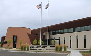
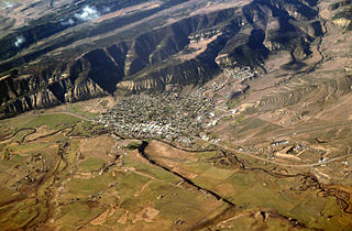
Montezuma County is a county located in the southwest corner of the U.S. state of Colorado. As of the 2020 census, the population was 25,849. The county seat is Cortez.

<span class="mw-page-title-main">Lincoln County, Colorado</span> County in Colorado, United States

Lincoln County is a county located in the U.S. state of Colorado. As of the 2020 census, the population was 5,675. The county seat is Hugo. The county obtains its name in memory of the United States President Abraham Lincoln. County was formed from portions of Bent and Elbert counties in 1889 from a restructuring of Colorado counties.

<span class="mw-page-title-main">Larimer County, Colorado</span> County in Colorado, United States

Larimer County is a county located in the U.S. state of Colorado. As of the 2020 census, the population was 359,066. The county seat and most populous city is Fort Collins. The county was named for William Larimer, Jr., the founder of Denver.

<span class="mw-page-title-main">Kiowa County, Colorado</span> County in Colorado, United States

Kiowa County is a county located in the U.S. state of Colorado. As of the 2020 census, the population was 1,446, making it the fifth-least populous county in Colorado. The county seat is Eads. The county was named for the Kiowa Nation of Native Americans.

<span class="mw-page-title-main">Cheyenne County, Colorado</span> County in Colorado, United States

Cheyenne County is a county located in the U.S. state of Colorado. The county population was 1,748 at 2020 census. The county seat is Cheyenne Wells.

<span class="mw-page-title-main">Parker, Arizona</span> Town in Arizona

Parker is the county seat of La Paz County, Arizona, United States, on the Colorado River in Parker Valley. As of the 2020 census, the population of the city was 3,417.

<span class="mw-page-title-main">Holbrook, Arizona</span> City in Navajo County, Arizona, US

Holbrook is a city in Navajo County, Arizona, United States. According to the 2010 census, the population of the city was 5,053. The city is the county seat of Navajo County.

<span class="mw-page-title-main">Yuma, Arizona</span> City in Arizona, United States

Yuma is a city in and the county seat of Yuma County, Arizona, United States. The city's population was 95,548 at the 2020 census, up from the 2010 census population of 93,064.

<span class="mw-page-title-main">Glendale, Colorado</span> City in Colorado, United States

The City of Glendale is a home rule municipality located in an exclave of Arapahoe County, Colorado, United States. The city population was 4,613 at the 2020 United States Census. Glendale is an enclave of the City and County of Denver and is the most densely populated municipality in Colorado. The city is a part of the Denver–Aurora–Lakewood, CO Metropolitan Statistical Area and the Front Range Urban Corridor.

<span class="mw-page-title-main">Las Animas, Colorado</span> City in Colorado, United States

Las Animas is the statutory city that is the county seat, the most populous community, and the only incorporated municipality in Bent County, Colorado, United States. The city population was 2,300 at the 2020 United States Census. Las Animas is located on the Arkansas River, just west of its confluence with the Purgatoire River, in southeast Colorado east of Pueblo, near the historic Bent's Fort.

<span class="mw-page-title-main">Salida, Colorado</span> City in Colorado, United States

Salida is the statutory city that is the county seat and the most populous municipality of Chaffee County, Colorado, United States. The population was 5,666 at the 2020 census.

<span class="mw-page-title-main">Eagle, Colorado</span> Town in Colorado, United States

Eagle is the Statutory Town that is the county seat of Eagle County, Colorado, United States. The town population was 7,511 at the 2020 United States Census, a +15.41% increase since the 2010 United States Census. Eagle is the part of the Edwards, CO Micropolitan Statistical Area.

<span class="mw-page-title-main">Limon, Colorado</span> Town in Colorado, United States

Limon is a statutory town that is the most populous municipality in Lincoln County, Colorado, United States. The population was 2,043 at the 2020 United States Census. Limon lies at the intersection of Interstate 70, U.S. Highways 24, 40, 287, and Colorado Highway 71. The Limon Correctional Facility is part of the Colorado Department of Corrections system and is a major employer in the area with employment of roughly 350.

<span class="mw-page-title-main">Fruita, Colorado</span> City in Colorado, United States

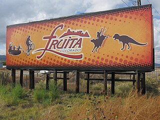
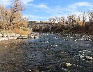
Fruita is a home rule municipality located in western Mesa County, Colorado, United States. The city population was 13,395 at the 2020 United States Census. Fruita is a part of the Grand Junction, CO Metropolitan Statistical Area and lies within the Grand Valley. The geography is identified by the bordering Colorado River on the southern edge of the town, the Uncompahgre Plateau known for its pinyon-juniper landscape, and the Book Cliffs range on the northern edge of the Grand Valley. Originally home to the Ute people, farmers settled the town after founder William Pabor in 1884. Ten years later, Fruita was incorporated.

<span class="mw-page-title-main">Cortez, Colorado</span> City in Colorado, United States

Cortez is a home rule municipality that is the county seat and the most populous municipality of Montezuma County, Colorado, United States. The city population was 8,766 at the 2020 United States Census.

<span class="mw-page-title-main">Meeker, Colorado</span> Town in and county seat of Rio Blanco County, Colorado, United States

Meeker is the Statutory Town in and the county seat of Rio Blanco County, Colorado, United States, that is the most populous municipality in the county. The town population was 2,374 at the 2020 United States Census.

<span class="mw-page-title-main">Laughlin, Nevada</span> Unincorporated community in the state of Nevada, United States

Laughlin is an unincorporated community in Clark County, Nevada, United States. Laughlin lies 90 miles (140 km) south of Las Vegas, in the far southern tip of Nevada. As a resort town, it is known for its gaming and water recreation. As of the 2020 census, the population was 8,658. For statistical purposes, the United States Census Bureau has defined Laughlin as a census-designated place (CDP). It is located on the Colorado River, downstream from the Davis Dam and Lake Mohave, and directly across from the much larger Bullhead City, Arizona. The nearby communities of Bullhead City, Arizona; Needles, California; Fort Mohave, Arizona; and Mohave Valley, Arizona, bring the area's total population to about 100,000. Laughlin is also 286 miles (460 km) northeast of Los Angeles.

<span class="mw-page-title-main">Torrington, Wyoming</span> City in Wyoming, United States

Torrington is a city in, and the county seat of, Goshen County, Wyoming, United States. The population was 6,501 at the 2010 census.

References

  1. 1 2 "Active Colorado Municipalities". State of Colorado, Department of Local Affairs. Archived from the original on December 12, 2009. Retrieved September 1, 2007.
  2. "Colorado Municipal Incorporations". State of Colorado, Department of Personnel & Administration, Colorado State Archives. December 1, 2004. Retrieved September 2, 2007.
  3. "2019 U.S. Gazetteer Files". Census.gov . United States Census Bureau. Retrieved July 1, 2020.
  4. "US Board on Geographic Names". United States Geological Survey. October 25, 2007. Retrieved January 31, 2008.
  5. 1 2 United States Census Bureau. "Hugo town; Colorado" . Retrieved April 22, 2023.
  6. "ZIP Code Lookup". United States Postal Service. Archived from the original (JavaScript/HTML) on November 4, 2010. Retrieved October 12, 2007.
  7. "Find a County". National Association of Counties. Archived from the original on May 31, 2011. Retrieved June 7, 2011.
  8. "Hugo's History". City of Hugo. Archived from the original on June 16, 2012. Retrieved July 14, 2012.
  9. A Historical & Biographical Record of the Territory of Arizona. Chicago, IL: McFarland & Poole. 1896. pp. 469–470.
  10. Conners, Jo (1913). Who's Who in Arizona. Tucson, AZ. pp. 769–770.{{cite book}}: |work= ignored (help)CS1 maint: location missing publisher (link)
  11. "Profile for Hugo, Colorado, CO". ePodunk. Archived from the original on February 9, 2013. Retrieved July 14, 2012.
  12. "City of Hugo Colorado". City of Hugo Colorado. Retrieved July 13, 2012.
  13. "Hugo, Colorado". City-Data.com. Retrieved July 13, 2012.
  14. "Colorado town finds THC in its water, warns residents not to drink or bathe in it – The Denver Post". July 21, 2016.
  15. "Hugo water safe to drink after conclusive tests show no signs of THC". July 23, 2016.
  16. "U.S. Climate Normals Quick Access". National Oceanic and Atmospheric Administration. Retrieved August 8, 2022.
  17. "NOAA Online Weather Data". National Weather Service. Retrieved August 8, 2022.