
Miami County is a county located in the U.S. state of Ohio. As of the 2020 census, the population was 108,774. Its county seat is Troy. The county is named in honor of the Miami people.

The Stillwater River is a 69.3-mile-long (111.5 km) tributary of the Great Miami River in western Ohio in the United States. Via the Great Miami and Ohio rivers, it is part of the Mississippi River watershed.

Mount Jefferson is an unincorporated community in Loramie Township, Shelby County, Ohio, United States. It lies along State Route 66 south of Houston. At 961 feet (293 m) above sea level, it is not on a summit, but is located on the south slope of the valley formed by Ninemile Creek, a tributary of Loramie Creek.
Ridgeville is an unincorporated community in central Clearcreek Township, Warren County, Ohio, United States. It is located on State Route 48 in the north central part of the county, in sections 30 and 36, T4R4, Between the Miami Rivers Survey.
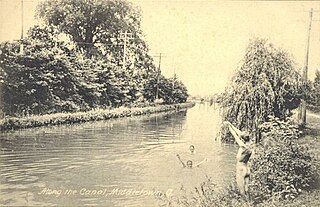
The Miami and Erie Canal was a 274-mile (441 km) canal that ran from Cincinnati to Toledo, Ohio, creating a water route between the Ohio River and Lake Erie. Construction on the canal began in 1825 and was completed in 1845 at a cost to the state government of $8 million. At its peak, it included 19 aqueducts, three guard locks, 103 canal locks, multiple feeder canals, and a few man-made water reservoirs. The canal climbed 395 feet (120 m) above Lake Erie and 513 feet (156 m) above the Ohio River to reach a topographical peak called the Loramie Summit, which extended 19 miles (31 km) between New Bremen, Ohio to lock 1-S in Lockington, north of Piqua, Ohio. Boats up to 80 feet long were towed along the canal by mules, horses, or oxen walking on a prepared towpath along the bank, at a rate of four to five miles per hour.

The Miami Valley is the land area surrounding the Great Miami River in southwest Ohio, USA, and includes the Little Miami, Mad, and Stillwater rivers as well. Geographically, it includes Dayton, Springfield, Middletown, Hamilton, and other communities. The name is derived from the Miami Indians.
Medway is an unincorporated community and census-designated place in Bethel Township, Clark County, Ohio, United States. It is part of the Springfield, Ohio Metropolitan Statistical Area. Near are the adjoining communities of Crystal Lakes and Park Layne. The population of its ZCTA for ZIP Code 45341, which includes Medway, was 4,110 at the 2000 census. Medway lies within the Tecumseh Local School District, whose high school mascot is the Arrows. Medway Elementary is the primary center of education for grades k-5.

Oregonia is an unincorporated community in northwestern Washington Township, Warren County, Ohio, United States, on the east shore of the Little Miami River about five miles northeast of Lebanon and six miles south of Waynesville. The ZIP Code for Oregonia is 45054.

Fosters is an unincorporated community in southern Warren County, Ohio, United States. It straddles the Little Miami River in Deerfield and Hamilton Townships. It is located about two miles southwest of Hopkinsville, two miles west of Maineville, and two miles northeast of Twenty Mile Stand just off U.S. Route 22/State Route 3, the 3C Highway. The community is in the Kings Local School District and is served by the Maineville post office. The settlement was originally called Foster's Crossing. The community was named after the local Foster family.

Shandon is an unincorporated community in southwestern Morgan Township, Butler County, Ohio, United States. It is located on Paddy's Run, a tributary of the Great Miami River, about four miles west of Ross at the intersection of State Routes 126 and 748 in section 25 of R1ET3N of the Congress Lands. It was originally called Glendower as the town was settled by immigrants from Wales. It was later called New London and this survives in the names of Alert-New London and Hamilton-New London Roads. The town is in the Ross Local School District.

Houston is an unincorporated community in northern Loramie Township, Shelby County, Ohio, United States. It has a post office, a dollar general, and a grain elevator.
Derwent is an unincorporated community in central Valley Township, Guernsey County, Ohio, United States. It is located near the southern border of Guernsey and Noble counties.

Phoneton is an unincorporated community in southwestern Bethel Township, Miami County, Ohio, United States, that is located at the junction of the National Road and Old Troy Pike in southwestern Bethel Township, Miami County, Ohio, United States. It is part of the Dayton Metropolitan Statistical Area.

Conover is an unincorporated community in eastern Brown Township, Miami County, Ohio, United States. It has a post office with the ZIP code 45317.
Miami University Hamilton is a satellite campus of Miami University in Hamilton, Ohio. It was founded in 1968 and is one of three regional campuses of Miami University.

Kirkwood is a rural unincorporated community located at the intersection of Kirkwood and River Roads in southwestern Orange Township, Shelby County, Ohio, United States.
Monterey is an unincorporated community in Clermont County, in the U.S. state of Ohio.
Lost Creek is a stream located entirely within Miami County, Ohio, United States. The 17.4-mile (28.0 km) long stream is a tributary of the Great Miami River.
Alcony is an unincorporated community in Miami County, in the U.S. state of Ohio.
Polo is an unincorporated community in Miami County, in the U.S. state of Ohio.

