Fletcher, Ohio

Last updated

Fletcher, Ohio
Fletcher, Main east of Walnut.jpg
Houses on Main Street
OHMap-doton-Fletcher.png
Location of Fletcher, Ohio
Map of Miami County Ohio Highlighting Fletcher Village.png
Location of Fletcher in Miami County
Coordinates: 40°08′30″N84°06′43″W / 40.14167°N 84.11194°W / 40.14167; -84.11194
Country United States
State Ohio
County Miami
Township Brown
Government
  TypeMayor with 6 Council Members
Area
[1]
  Total0.31 sq mi (0.80 km2)
  Land0.31 sq mi (0.80 km2)
  Water0.00 sq mi (0.00 km2)
Elevation
[2]
1,053 ft (321 m)
Population
 (2020)
  Total451
  Density1,450.16/sq mi (560.32/km2)
Time zone UTC-5 (Eastern (EST))
  Summer (DST) UTC-4 (EDT)
ZIP code
45326
Area code(s) 937, 326
FIPS code 39-27412 [3]
GNIS feature ID2398885 [2]
Website https://fletcherohio.us/

Fletcher is a village in Miami County, Ohio, United States. The population was 451 at the 2020 census. It is part of the Dayton Metropolitan Statistical Area.

Contents

History

Fletcher was platted in 1830. [4] The village was named after Samuel Fletcher, a local storekeeper. [5] The post office that had been in operation at Fletcher since 1831 [6] closed in 2010. [7]

Geography

According to the United States Census Bureau, the village has a total area of 0.31 square miles (0.80 km2), all land. [8] Fletcher is drained by East Branch Lost Creek and West Branch Lost Creek.

The village is crossed by U.S. Route 36 and State Route 589.

Demographics

Historical population
CensusPop.Note
1850 246
1860 29821.1%
1870 3062.7%
1880 38425.5%
1900 375
1910 3760.3%
1920 369−1.9%
1930 40710.3%
1940 4367.1%
1950 51518.1%
1960 56910.5%
1970 539−5.3%
1980 498−7.6%
1990 5459.4%
2000 510−6.4%
2010 473−7.3%
2020 451−4.7%
U.S. Decennial Census [9]

2010 census

As of the census [10] of 2010, there were 473 people, 175 households, and 133 families living in the village. The population density was 1,525.8 inhabitants per square mile (589.1/km2). There were 197 housing units at an average density of 635.5 per square mile (245.4/km2). The racial makeup of the village was 97.0% White, 0.2% Native American, 0.6% from other races, and 2.1% from two or more races. Hispanic or Latino of any race were 0.8% of the population.

There were 175 households, of which 40.6% had children under the age of 18 living with them, 56.6% were married couples living together, 11.4% had a female householder with no husband present, 8.0% had a male householder with no wife present, and 24.0% were non-families. 20.0% of all households were made up of individuals, and 8.6% had someone living alone who was 65 years of age or older. The average household size was 2.70 and the average family size was 3.06.

The median age in the village was 36 years. 27.7% of residents were under the age of 18; 8.1% were between the ages of 18 and 24; 26.4% were from 25 to 44; 24.9% were from 45 to 64; and 12.9% were 65 years of age or older. The gender makeup of the village was 51.6% male and 48.4% female.

2000 census

As of the census [3] of 2000, there were 510 people, 189 households, and 144 families living in the village. The population density was 1,651.8 inhabitants per square mile (637.8/km2). There were 207 housing units at an average density of 670.5 per square mile (258.9/km2). The racial makeup of the village was 98.04% White, 0.59% African American, 0.78% Native American, and 0.59% from two or more races. Hispanic or Latino of any race were 0.59% of the population.

There were 189 households, out of which 37.6% had children under the age of 18 living with them, 61.4% were married couples living together, 10.6% had a female householder with no husband present, and 23.3% were non-families. 20.1% of all households were made up of individuals, and 9.5% had someone living alone who was 65 years of age or older. The average household size was 2.70 and the average family size was 3.09.

In the village, the population was spread out, with 29.0% under the age of 18, 10.2% from 18 to 24, 29.4% from 25 to 44, 17.3% from 45 to 64, and 14.1% who were 65 years of age or older. The median age was 32 years. For every 100 females there were 103.2 males. For every 100 females age 18 and over, there were 104.5 males.

The median income for a household in the village was $41,583, and the median income for a family was $45,179. Males had a median income of $31,458 versus $26,125 for females. The per capita income for the village was $19,538. About 6.8% of families and 9.4% of the population were below the poverty line, including 8.8% of those under age 18 and 12.5% of those age 65 or over.

Economy

A Systemax factory located just east of Fletcher closed December 31, 2012. [11]

There is a local automotive shop, Jack's Garage, that has been in business since 1975.

Agriculture remains an integral part of life in Fletcher as the grain elevator, once owned by the Shepard Grain Company, is now owned by Urbana-based Champaign Landmark Inc.

An AT&T microwave radio relay tower (now abandoned) once provided several jobs for area residents. It remains standing (with the ear-shaped antennas now removed) a mile east of the village along U.S. Route 36. Ohio Bell operated the facility prior to the divestiture of the AT&T-owned Bell System in the 1980s. AT&T continued to operate the tower until the advent of fiber-optic cables and satellites which led to the replacement for the underground coaxial cable network and the use of the 318-foot steel structure now sitting vacant within the eastern Miami County farm fields.

Notable people

Elected officials

Mayor: Penny Reed[ citation needed ]

Related Research Articles

<span class="mw-page-title-main">Miami County, Ohio</span> County in Ohio, United States

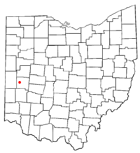
Miami County is a county located in the U.S. state of Ohio. As of the 2020 census, the population was 108,774. Its county seat is Troy. The county is named in honor of the Miami people.

<span class="mw-page-title-main">Spencerville, Ohio</span> Village in Ohio, United States

Spencerville is a village in Allen County, Ohio, United States. The population was 2,198 at the 2020 census. It is included in the Lima, Ohio Metropolitan Statistical Area.

<span class="mw-page-title-main">South Charleston, Ohio</span> Village in Ohio, United States

South Charleston is a village in Clark County, Ohio, United States. The population was 1,706 at the 2020 census. It is part of the Springfield, Ohio Metropolitan Statistical Area.

<span class="mw-page-title-main">Arcanum, Ohio</span> Village in Ohio, United States

Arcanum is a village in Darke County, Ohio, United States. The population was 2,457 at the 2020 census.

<span class="mw-page-title-main">Castine, Ohio</span> Village in Ohio, United States

Castine is a village in Darke County, Ohio, United States. The population was 110 at the 2020 census.

<span class="mw-page-title-main">Spring Valley, Ohio</span> Village in Ohio, United States

Spring Valley is a village in Greene County, Ohio, United States. The population was 415 at the 2020 census. It is part of the Dayton Metropolitan Statistical Area.

<span class="mw-page-title-main">Addyston, Ohio</span> Village in Ohio, United States

Addyston is a village in Miami Township, Hamilton County, Ohio, United States. Located along the Ohio River, it is a western suburb of the neighboring city of Cincinnati. The population was 927 at the 2020 census.

<span class="mw-page-title-main">Cleves, Ohio</span> City in Ohio, United States

Cleves is a village in Miami Township, Hamilton County, Ohio, United States. Located along the Ohio River, it is a western suburb of Cincinnati. The population was 3,414 at the 2020 census.

<span class="mw-page-title-main">Mowrystown, Ohio</span> Village in Ohio, United States

Mowrystown is a village in Highland County, Ohio, United States. The population was 385 at the 2020 census.

<span class="mw-page-title-main">Grand River, Ohio</span> Village in Ohio, United States

Grand River is a village in Lake County, Ohio, United States, along the Grand River. The population was 394 at the 2020 census.

<span class="mw-page-title-main">Covington, Ohio</span> Village in Ohio, United States

Covington is a village in Miami County, Ohio, United States. The population was 2,548 at the 2020 census. It is part of the Dayton Metropolitan Statistical Area. The village was incorporated as Covington in 1835 on the site of the 1793 Fort Rowdy.

<span class="mw-page-title-main">Laura, Ohio</span> Village in Ohio, United States

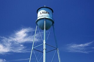
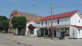
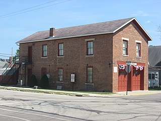
Laura is a village in Miami County, Ohio, United States. The population was 398 at the 2020 census. It is part of the Dayton Metropolitan Statistical Area.

<span class="mw-page-title-main">Ludlow Falls, Ohio</span> Village in Ohio, United States

Ludlow Falls is a village in Miami County, Ohio, United States. The population was 175 at the 2020 census. It is part of the Dayton Metropolitan Statistical Area. Ludlow Falls is named after surveyor Israel Ludlow.

<span class="mw-page-title-main">Pleasant Hill, Ohio</span> Village in Ohio, United States

Pleasant Hill is a village in Miami County, Ohio, United States. The population was 1,241 at the 2020 census. It is part of the Dayton Metropolitan Statistical Area.

<span class="mw-page-title-main">Potsdam, Ohio</span> Village in Ohio, United States

Potsdam is a village in Miami County, Ohio, United States. The population was 225 at the 2020 census. It is part of the Dayton Metropolitan Statistical Area.

<span class="mw-page-title-main">Cloverdale, Ohio</span> Village in Ohio, United States

Cloverdale is a village in Perry Township, Putnam County, Ohio, United States. The population was 170 at the 2020 census.

<span class="mw-page-title-main">Port Jefferson, Ohio</span> Village in Ohio, United States

Port Jefferson is a village in Salem Township, Shelby County, Ohio, United States. The population was 308 at the 2020 census.

<span class="mw-page-title-main">Limaville, Ohio</span> Census-designated place in Ohio, United States

Limaville is a census-designated place (CDP) and former village in Stark County, Ohio, United States. The population was 151 at the 2020 census. It is part of the Canton–Massillon Metropolitan Statistical Area.

<span class="mw-page-title-main">Waynesville, Ohio</span> Village in Ohio, United States

Waynesville is a village in Wayne Township, Warren County, Ohio, United States. The population was 2,669 at the 2020 census. It is named for General "Mad" Anthony Wayne. The village, located at the crossroads of U.S. Route 42 and State Route 73, is known for its antique stores and its annual sauerkraut festival. Caesar Creek State Park is located 5 miles (8.0 km) east of the village.

<span class="mw-page-title-main">Clifton, Ohio</span> Village in Ohio, United States

Clifton is a village in Clark and Greene counties in the U.S. state of Ohio and is home to the Clifton Mill, one of the largest water-powered grist mills still in existence. The population was 131 at the 2020 census.

References

  1. "ArcGIS REST Services Directory". United States Census Bureau. Retrieved September 20, 2022.
  2. 1 2 U.S. Geological Survey Geographic Names Information System: Fletcher, Ohio
  3. 1 2 "U.S. Census website". United States Census Bureau . Retrieved January 31, 2008.
  4. The History of Miami County, Ohio: Containing a History of the County; Its Cities, Towns, Etc. Windmill Publications. 1880. p. 317.
  5. Overman, William Daniel (1958). Ohio Town Names. Akron, OH: Atlantic Press. p. 45.
  6. "Miami County". Jim Forte Postal History. Archived from the original on September 9, 2005. Retrieved January 9, 2016.
  7. "Post Offices Closing - The Wall Street Journal Online - Interactive Graphics". online.wsj.com. Retrieved August 28, 2017.
  8. "US Gazetteer files 2010". United States Census Bureau. Archived from the original on January 25, 2012. Retrieved January 6, 2013.
  9. "Census of Population and Housing". Census.gov. Retrieved June 4, 2015.
  10. "U.S. Census website". United States Census Bureau . Retrieved January 6, 2013.
  11. "Systemax closing date set". www.bizjournals.com. Retrieved August 28, 2017.