Pleasant Hill, Ohio

Last updated

Pleasant Hill, Ohio
Pleasant Hill memorial to the GAR.jpg
Pleasant Hill's Civil War monument
OHMap-doton-Pleasant Hill.png
Location of Pleasant Hill, Ohio
Map of Miami County Ohio Highlighting Pleasant Hill Village.png
Location of Pleasant Hill in Miami County
Coordinates: 40°03′02″N84°20′46″W / 40.05056°N 84.34611°W / 40.05056; -84.34611
Country United States
State Ohio
County Miami
Township Newton
Government
   Mayor Brenda Carroll
  President-Pro TemPenny Fessler
  Council MembersPenny Fessler, Teri Stivers, Faith Renner, Lee Rademachir, Charles Tackett, Matt Gray
Area
[1]
  Total0.63 sq mi (1.63 km2)
  Land0.63 sq mi (1.63 km2)
  Water0.00 sq mi (0.00 km2)
Elevation
[2]
925 ft (282 m)
Population
 (2020)
  Total1,241
  Density1,972.97/sq mi (761.70/km2)
Time zone UTC-5 (Eastern (EST))
  Summer (DST) UTC-4 (EDT)
ZIP code
45359
Area code(s) 937, 326
FIPS code 39-63534 [3]
GNIS feature ID2399691 [2]
Website http://www.pleasanthillohio.com

Pleasant Hill is a village in Miami County, Ohio, United States. The population was 1,241 at the 2020 census. It is part of the Dayton Metropolitan Statistical Area.

Contents

History

Pleasant Hill was originally called Newton, and under the latter name was platted in 1843. [4] A post office called Pleasant Hill has been in operation since 1839, [5] although the post office was originally located about one mile away from its present location. [6] The village was incorporated in 1866. [7]

Geography

According to the United States Census Bureau, the village has a total area of 0.61 square miles (1.58 km2), all land. [8]

Demographics

Historical population
CensusPop.Note
1870 324
1880 46142.3%
1890 52113.0%
1900 5576.9%
1910 5712.5%
1920 68219.4%
1930 7469.4%
1940 738−1.1%
1950 94027.4%
1960 1,06012.8%
1970 1,025−3.3%
1980 1,0512.5%
1990 1,0661.4%
2000 1,1346.4%
2010 1,2005.8%
2020 1,2413.4%
U.S. Decennial Census [9]

2010 census

As of the census [10] of 2010, there were 1,200 people, 458 households, and 327 families living in the village. The population density was 1,967.2 inhabitants per square mile (759.5/km2). There were 498 housing units at an average density of 816.4 per square mile (315.2/km2). The racial makeup of the village was 98.7% White, 0.3% African American, 0.1% Native American, 0.3% Asian, 0.2% from other races, and 0.6% from two or more races. Hispanic or Latino of any race were 1.9% of the population.

There were 458 households, of which 39.1% had children under the age of 18 living with them, 59.8% were married couples living together, 7.9% had a female householder with no husband present, 3.7% had a male householder with no wife present, and 28.6% were non-families. 24.0% of all households were made up of individuals, and 11.8% had someone living alone who was 65 years of age or older. The average household size was 2.62 and the average family size was 3.15.

The median age in the village was 35.7 years. 27.7% of residents were under the age of 18; 8.9% were between the ages of 18 and 24; 26% were from 25 to 44; 23.4% were from 45 to 64; and 14.1% were 65 years of age or older. The gender makeup of the village was 48.4% male and 51.6% female.

2000 census

As of the census [3] of 2000, there were 1,134 people, 423 households, and 326 families living in the village. The population density was 2,393.0 inhabitants per square mile (923.9/km2). There were 437 housing units at an average density of 922.2 per square mile (356.1/km2). The racial makeup of the village was 99.38% White, 0.09% Native American, 0.18% Asian, and 0.35% from two or more races. Hispanic or Latino of any race were 0.26% of the population.

There were 423 households, 39.2% had children under the age of 18 living with them, 68.3% were married couples living together, 7.6% had a female householder with no husband present, and 22.7% were non-families. 19.6% of all households were made up of individuals, and 10.2% had someone living alone who was 65 years of age or older. The average household size was 2.68 and the average family size was 3.10.

In the village, the population was spread out, with 29.9% under the age of 18, 5.6% from 18 to 24, 29.9% from 25 to 44, 21.6% from 45 to 64, and 13.1% who were 65 years of age or older. The median age was 35 years. For every 100 females there were 91.9 males. For every 100 females age 18 and over, there were 87.5 males.

The median income for a household in the village was $45,703, and the median income for a family was $50,260. Males had a median income of $38,036 versus $23,750 for females. The per capita income for the village was $18,477. About 2.1% of families and 2.6% of the population were below the poverty line, including 3.6% of those under age 18 and 1.6% of those age 65 or over.

Education

Pleasant Hill has a public library, a branch of the Troy-Miami County Public Library. [11]

Related Research Articles

<span class="mw-page-title-main">Miami County, Ohio</span> County in Ohio, United States

Miami County is a county located in the U.S. state of Ohio. As of the 2020 census, the population was 108,774. Its county seat is Troy. The county is named in honor of the Miami people.

<span class="mw-page-title-main">Castine, Ohio</span> Village in Ohio, United States

Castine is a village in Darke County, Ohio, United States. The population was 110 at the 2020 census.

<span class="mw-page-title-main">Ithaca, Ohio</span> Village in Ohio, United States

Ithaca is a village in Darke County, Ohio, United States. The population was 81 at the 2020 census.

<span class="mw-page-title-main">Union City, Ohio</span> Village in Ohio, United States

Union City is a village in Darke County, Ohio, United States. The population was 1,582 at the 2020 census. It is directly across the state line from its twin city of Union City, Indiana.

<span class="mw-page-title-main">Cheshire, Ohio</span> Village in Ohio, United States

Cheshire is a village in Gallia County, Ohio, United States, along the Ohio River. The population was 123 at the 2020 census. It is part of the rural Point Pleasant micropolitan area.

<span class="mw-page-title-main">Vinton, Ohio</span> Village in Ohio, United States

Vinton is a village in Gallia County, Ohio, United States. The population was 224 at the 2020 census. It is part of the rural Point Pleasant micropolitan area.

<span class="mw-page-title-main">Pleasant City, Ohio</span> Village in Ohio, United States

Pleasant City is a village in Guernsey County, Ohio, United States. The population was 400 at the 2020 census.

<span class="mw-page-title-main">Addyston, Ohio</span> Village in Ohio, United States

Addyston is a village in Miami Township, Hamilton County, Ohio, United States. Located along the Ohio River, it is a western suburb of the neighboring city of Cincinnati. The population was 927 at the 2020 census.

<span class="mw-page-title-main">Cleves, Ohio</span> City in Ohio, United States

Cleves is a village in Miami Township, Hamilton County, Ohio, United States. Located along the Ohio River, it is a western suburb of Cincinnati. The population was 3,414 at the 2020 census.

<span class="mw-page-title-main">Casstown, Ohio</span> Village in Ohio, United States

Casstown is a village in Miami County, Ohio, United States. The population was 270 at the 2020 census. It is part of the Dayton Metropolitan Statistical Area.

<span class="mw-page-title-main">Covington, Ohio</span> Village in Ohio, United States

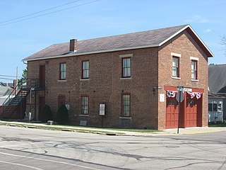
Covington is a village in Miami County, Ohio, United States. The population was 2,548 at the 2020 census. It is part of the Dayton Metropolitan Statistical Area. The village was incorporated as Covington in 1835 on the site of the 1793 Fort Rowdy.

<span class="mw-page-title-main">Laura, Ohio</span> Village in Ohio, United States

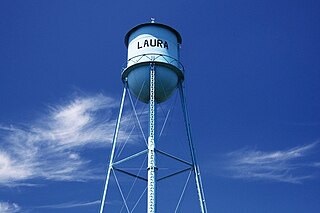
Laura is a village in Miami County, Ohio, United States. The population was 398 at the 2020 census. It is part of the Dayton Metropolitan Statistical Area.

<span class="mw-page-title-main">Ludlow Falls, Ohio</span> Village in Ohio, United States

Ludlow Falls is a village in Miami County, Ohio, United States. The population was 175 at the 2020 census. It is part of the Dayton Metropolitan Statistical Area. Ludlow Falls is named after surveyor Israel Ludlow.

<span class="mw-page-title-main">Butlerville, Ohio</span> Village in Ohio, United States

Butlerville is a village in central Harlan Township, Warren County, Ohio, United States, located in the southwestern part of the state. The population was 155 at the 2020 census.

<span class="mw-page-title-main">Corwin, Ohio</span> Village in Ohio, United States

Corwin is a village in Wayne Township, Warren County, Ohio, United States. The population was 484 at the 2020 census.

<span class="mw-page-title-main">Pleasant Plain, Ohio</span> Village in Ohio, United States

Pleasant Plain is a village in Harlan Township, Warren County, Ohio, United States. The population was 129 at the 2020 census.

<span class="mw-page-title-main">Macksburg, Ohio</span> Village in Ohio, United States

Macksburg is a village in Washington County, Ohio, United States, along the West Fork of Duck Creek. The population was 120 at the 2020 census. The village is about 28 miles (45 km) south of Cambridge, Ohio.

<span class="mw-page-title-main">Bradner, Ohio</span> Village in Ohio, United States

Bradner is a village in Wood County, Ohio, United States. The population was 971 at the 2020 census.

<span class="mw-page-title-main">Bradford, Ohio</span> Village in Ohio, United States

Bradford is a village in Darke and Miami counties in the U.S. state of Ohio. The population was 1,796 at the 2020 census.

<span class="mw-page-title-main">Plain City, Ohio</span> Village in Ohio, United States

Plain City is a village in Madison and Union counties in the U.S. state of Ohio, along Big Darby Creek. The population was 4,065 at the 2020 census.

References

  1. "ArcGIS REST Services Directory". United States Census Bureau. Retrieved September 20, 2022.
  2. 1 2 U.S. Geological Survey Geographic Names Information System: Pleasant Hill, Ohio
  3. 1 2 "U.S. Census website". United States Census Bureau . Retrieved January 31, 2008.
  4. The History of Miami County, Ohio: Containing a History of the County; Its Cities, Towns, Etc. Windmill Publications. 1880. p. 366.
  5. "Miami County". Jim Forte Postal History. Retrieved January 9, 2016.
  6. Overman, William Daniel (1958). Ohio Town Names. Akron, OH: Atlantic Press. p. 112.
  7. Harbaugh, T. C. (1909). Centennial history. Troy, Piqua and Miami county, Ohio. Chicago: Richmond-Arnold Publishing Co. p. 95.
  8. "US Gazetteer files 2010". United States Census Bureau. Archived from the original on January 25, 2012. Retrieved January 6, 2013.
  9. "Census of Population and Housing". Census.gov. Retrieved June 4, 2015.
  10. "U.S. Census website". United States Census Bureau . Retrieved January 6, 2013.
  11. "Hours". Troy-Miami County Public Library. Retrieved March 1, 2018.