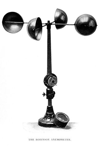
In meteorology, an anemometer is a device that measures wind speed and direction. It is a common instrument used in weather stations. The earliest known description of an anemometer was by Italian architect and author Leon Battista Alberti (1404–1472) in 1450.

A pitot tube measures fluid flow velocity. It was invented by a French engineer, Henri Pitot, in the early 18th century, and was modified to its modern form in the mid-19th century by a French scientist, Henry Darcy. It is widely used to determine the airspeed of aircraft; the water speed of boats; and the flow velocity of liquids, air, and gases in industry.

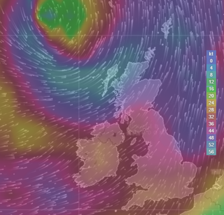
In meteorology, wind speed, or wind flow speed, is a fundamental atmospheric quantity caused by air moving from high to low pressure, usually due to changes in temperature. Wind speed is now commonly measured with an anemometer.
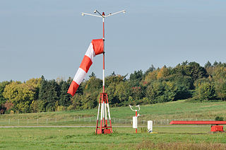
A windsock is a conical textile tube that resembles a giant sock. It can be used as a basic indicator of wind speed and direction, or as decoration. Windsocks are typically used at airports to show the direction and strength of the wind to pilots, and at chemical plants where there is risk of gaseous leakage. They are also sometimes located alongside highways at windy locations.

A weather station is a facility, either on land or sea, with instruments and equipment for measuring atmospheric conditions to provide information for weather forecasts and to study the weather and climate. The measurements taken include temperature, atmospheric pressure, humidity, wind speed, wind direction, and precipitation amounts. Wind measurements are taken with as few other obstructions as possible, while temperature and humidity measurements are kept free from direct solar radiation, or insolation. Manual observations are taken at least once daily, while automated measurements are taken at least once an hour. Weather conditions out at sea are taken by ships and buoys, which measure slightly different meteorological quantities such as sea surface temperature (SST), wave height, and wave period. Drifting weather buoys outnumber their moored versions by a significant amount.

A wind vane, weather vane, or weathercock is an instrument used for showing the direction of the wind. It is typically used as an architectural ornament to the highest point of a building. The word vane comes from the Old English word fana, meaning "flag".
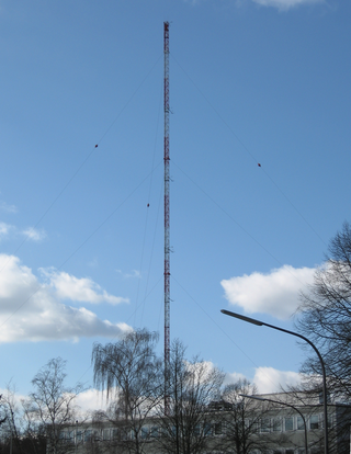
A measurement tower or measurement mast, also known as meteorological tower or meteorological mast, is a free standing tower or a removed mast, which carries measuring instruments with meteorological instruments, such as thermometers and instruments to measure wind speed. Measurement towers are an essential component of rocket launching sites, since one must know exact wind conditions for an execution of a rocket launch. Met masts are crucial in the development of wind farms, as precise knowledge of the wind speed is necessary to know how much energy will be produced, and whether the turbines will survive on the site. Measurement towers are also used in other contexts, for instance near nuclear power stations, and by ASOS stations.

An automatic weather station (AWS) is an automated version of the traditional weather station, either to save human labor or to enable measurements from remote areas. An AWS will typically consist of a weather-proof enclosure containing the data logger, rechargeable battery, telemetry (optional) and the meteorological sensors with an attached solar panel or wind turbine and mounted upon a mast. The specific configuration may vary due to the purpose of the system. The system may report in near real time via the Argos System, LoRa and the Global Telecommunications System, or save the data for later recovery.

A pitot–static system is a system of pressure-sensitive instruments that is most often used in aviation to determine an aircraft's airspeed, Mach number, altitude, and altitude trend. A pitot–static system generally consists of a pitot tube, a static port, and the pitot–static instruments. Other instruments that might be connected are air data computers, flight data recorders, altitude encoders, cabin pressurization controllers, and various airspeed switches. Errors in pitot–static system readings can be extremely dangerous as the information obtained from the pitot static system, such as altitude, is potentially safety-critical. Several commercial airline disasters have been traced to a failure of the pitot–static system.

Roughness length is a parameter of some vertical wind profile equations that model the horizontal mean wind speed near the ground. In the log wind profile, it is equivalent to the height at which the wind speed theoretically becomes zero in the absence of wind-slowing obstacles and under neutral conditions. In reality, the wind at this height no longer follows a mathematical logarithm. It is so named because it is typically related to the height of terrain roughness elements. For instance, forests tend to have much larger roughness lengths than tundra. The roughness length does not exactly correspond to any physical length. However, it can be considered as a length-scale representation of the roughness of the surface.
An anemoscope is a device designed to show the direction of the wind, or to indicate a change of wind direction. The name is usually applied to an apparatus consisting of a wind vane above, connecting to a building below by some kind of coupling, and with a dial or index with pointers to show the direction and changes of the wind.

Meteorological instruments, including meteorological sensors, are the equipment used to find the state of the atmosphere at a given time. Each science has its own unique sets of laboratory equipment. Meteorology, however, is a science which does not use much laboratory equipment but relies more on on-site observation and remote sensing equipment. In science, an observation, or observable, is an abstract idea that can be measured and for which data can be taken. Rain was one of the first quantities to be measured historically. Two other accurately measured weather-related variables are wind and humidity. Many attempts had been made prior to the 15th century to construct adequate equipment to measure atmospheric variables.

The following outline is provided as an overview of and topical guide to the field of Meteorology.
Surface weather observations are the fundamental data used for safety as well as climatological reasons to forecast weather and issue warnings worldwide. They can be taken manually, by a weather observer, by computer through the use of automated weather stations, or in a hybrid scheme using weather observers to augment the otherwise automated weather station. The ICAO defines the International Standard Atmosphere (ISA), which is the model of the standard variation of pressure, temperature, density, and viscosity with altitude in the Earth's atmosphere, and is used to reduce a station pressure to sea level pressure. Airport observations can be transmitted worldwide through the use of the METAR observing code. Personal weather stations taking automated observations can transmit their data to the United States mesonet through the Citizen Weather Observer Program (CWOP), the UK Met Office through their Weather Observations Website (WOW), or internationally through the Weather Underground Internet site. A thirty-year average of a location's weather observations is traditionally used to determine the station's climate. In the US a network of Cooperative Observers make a daily record of summary weather and sometimes water level information.

Wind is the natural movement of air or other gases relative to a planet's surface. Winds occur on a range of scales, from thunderstorm flows lasting tens of minutes, to local breezes generated by heating of land surfaces and lasting a few hours, to global winds resulting from the difference in absorption of solar energy between the climate zones on Earth. The two main causes of large-scale atmospheric circulation are the differential heating between the equator and the poles, and the rotation of the planet. Within the tropics and subtropics, thermal low circulations over terrain and high plateaus can drive monsoon circulations. In coastal areas the sea breeze/land breeze cycle can define local winds; in areas that have variable terrain, mountain and valley breezes can prevail.
A gust or wind gust is a brief increase in the speed of the wind, usually less than 20 seconds. It is of a more transient character than a squall, which lasts minutes, and is followed by a lull or slackening in the wind speed. Generally, winds are least gusty over large water surfaces and most gusty over rough land and near high buildings.

An air data boom provides air pressure, temperature, and airflow direction data to data acquisition systems for the computation of air, ground, and water vehicle orientation, speed, altitude/depth, and related information. Air data booms can be used as primary sensors or as a "measurement standard" of which primary sensors and instruments are compared to.

This glossary of meteorology is a list of terms and concepts relevant to meteorology and atmospheric science, their sub-disciplines, and related fields.
Xiangfeng wu were wind surveying instruments used to gather and measure the direction of the wind in ancient China.