WorldWide Telescope (WWT) is an open-source set of applications, data and cloud services,[4][5] originally created by Microsoft Research but now an open source project hosted on GitHub.[6] The .NET Foundation holds the copyright and the project is managed by the American Astronomical Society and has been supported by grants from the Moore Foundation and National Science Foundation. WWT displays astronomical, earth and planetary data allowing visual navigation through the 3-dimensional (3D) Universe. Users are able to navigate the sky by panning and zooming, or explore the 3D universe from the surface of Earth to past the Cosmic microwave background (CMB), viewing both visual imagery and scientific data (academic papers, etc.) about that area and the objects in it. Data is curated from hundreds of different data sources, but its open data nature allows users to explore any third party data that conforms to a WWT supported format. With the rich source of multi-spectral all-sky images it is possible to view the sky in many wavelengths of light.[7] The software utilizes Microsoft's Visual Experience Engine technologies to function.[8] WWT can also be used to visualize arbitrary or abstract data sets and time series data.
WWT is completely free and currently comes in two versions: a native application that runs under Microsoft Windows[9] (this version can use the specialized capabilities of a computer graphics card to render up to a half million data points), and a web client based on HTML5 and WebGL.[10] The web client uses a responsive design which allows people to use it on smartphones and on desktops. The Windows desktop application is a high-performance system which scales from a desktop to large multi-channel full dome digital planetariums.[11]
The WWT project began in 2002, at Microsoft Research and Johns Hopkins University. Database researcher Jim Gray had developed a satellite Earth-images database (Terraserver) and wanted to apply a similar technique to organizing the many disparate astronomical databases of sky images.[12] WWT was announced at the TED Conference in Monterey, California in February 2008.[13] As of 2016, WWT has been downloaded by at least 10 million active users."[14]
As of February 2012 the earth science applications of WWT are showcased and supported by the Layerscape community collaboration website, also created by Microsoft Research. Since WWT has gone to Open Source Layerscape communities have been brought into the WWT application and re-branded simply "communities".
Features
Modes
WorldWide Telescope has six main modes. These are Sky, Earth, Planets, Panoramas, Solar System and Sandbox.[11]
Earth
Earth mode allows users to view a 3D model of the Earth, similar to NASA World Wind, Microsoft Virtual Earth and Google Earth. The Earth mode has a default data set with near global coverage and resolution down to sub-meter in high-population centers. Unlike most Earth viewers, WorldWide Telescope supports many different map projections including Mercator, Equirectangular and Tessellated Octahedral Adaptive Subdivision Transform (TOAST). There are also map layers for seasonal, night, streets, hybrid and science oriented Moderate-Resolution Imaging Spectroradiometer (MODIS) imagery. The new layer manager can be used to add data visualization on the Earth or other planets.[11]
Planets
Planets mode currently allows users to view 3D models of eight celestial bodies: Venus, Mars, Jupiter, the Galilean moons of Jupiter, and our own planet's moon. It also allows users to view a Mandelbrot set.[11]
Sky
Sky mode is the main feature of the software. It allows users to view high quality images of outer space with images from many space and Earth-based telescopes. Each image is shown at its actual position in the sky. There are over 200 full-sky images in spectral bands ranging from radio to gamma-rays There are also thousands of individual study images of various astronomical objects from space telescopes such as the Hubble Space Telescope, the Spitzer Space Telescope in infrared, the Chandra X-ray Observatory, COBE, WMAP, ROSAT, IRAS, GALEX as well as many other space and ground-based telescopes.[11] Sky mode also shows the Sun, Moon, planets, and their moons in their current positions.
Users can add their own image data from FITS files or can convert them to standard image formats such as JPEG, PNG, TIFF. These images can be formatted with the astronomical visual metadata (AVM).
Users can include their own panoramas, created by gigapixel panoramas such as the ones available for HDView.,[11] or single-shot spherical cameras, such as the Ricoh Theta.
Solar System
This mode displays the major solar system objects from the Sun to Pluto, and Jupiter's moons, orbits of all solar system moons, all 550,000+ minor planets all positioned with their correct scale, position and phase. The user can move forward and backward in time at various rates, or type in a time and date for which to view the positions of the planets, and can select viewing location. The program can show the solar system the way it would look from any location at any time between 1 AD and 4000 AD. Using this tool a user can watch an eclipse (e.g., 2017 total solar eclipse) occultation, or astronomical alignment, and preview where the best spot might be to observe a future event.[11] In this mode it is possible to zoom away from the Solar System, through the Milky Way, and out into the cosmos to see a hypothetical view of the entire known universe. Other bodies, spacecraft and orbital reference frames can be added and visualized in the Solar System Mode using the layer manager.
Users can query the Minor Planet Center for the orbits of minor bodies in the solar system, such as
Sandbox
The Sandbox mode allows users to view arbitrary 3d models (OBJ or 3DS formats) in an empty universe. For instance, this is useful to explore 3D objects such as molecular data.
Local user content
WorldWide Telescope was designed as a professional research environment and as such it facilitates viewing of user data. Virtually all of the data types and visualizations in WorldWide Telescope can be run using supplied user data either locally or over the network. Any of the above viewing modes allow the user to browse and load equirectangular, fisheye, or dome master images to be viewed as planet surfaces, sky images or panoramas. Images with Astronomy Visualization Metadata (AVM) can be loaded and registered to their location in the sky. Images without AVM can be shown on the sky but the user must align the images in the sky by moving, scaling and rotating the images until star patterns align. Once the images are aligned they can be saved to collections for later viewing and sharing. The layer manager can be used to add vector or image data to planet surfaces or in orbit.[11]
Layer Manager
Introduced in the Aphelion release, the Layer Manager allows management of relative reference frames allowing data and images to be places on Earth, the planets, moons, the sky or anywhere else in the universe. Data can be loaded from files, linked live with Microsoft Excel, or pasted in from other applications. Layers support 3D points and Well-known text representation of geometry (WKT), shape files, 3D models, orbital elements, image layers and more. Time series data can be viewed to see smoothly animated events over time. Reference frames can contain orbital information allowing 3d models or other data to be plotted at their correct location over time.
Use for amateur astronomy
The program allows the selection of a telescope and camera and can preview the field of view against the sky. Using ASCOM the user can connect a computer-controlled telescope or an astronomical pointing device such as Meade's MySky, and then either control or follow it. The large selection of catalog objects and 1 arc-second-per-pixel imagery allow an astrophotographer to select and plan a photograph and find a suitable guide star using the multi-chip FOV indicator.[11]
Tours
WorldWide Telescope contains a multimedia authoring environment that allows users or educators to create tours with a simple slide-based paradigm. The slides can have a begin and end camera position allowing for easy Ken Burns Effects. Pictures, objects, and text can be added to the slides, and tours can have both background music and voice-overs with separate volume control. The layer manager can be used in conjunction with a tour to publish user data visualizations with annotations and animations. One of the tours featured was made by a six-year-old boy, while other tours are made by astrophysicists such as Dr. Alyssa A. Goodman of the Center for Astrophysics | Harvard & Smithsonian and Dr. Robert L. Hurt of Caltech/JPL.[11]
Communities
Communities are a way of allowing organizations and communities to add their own images, tours, catalogs and research materials to the WorldWide Telescope interface. The concept is similar to subscribing to a RSS feed except the contents are astronomical metadata.[11]
Virtual observatory
The WorldWide Telescope was designed to be the embodiment of a rich virtual observatory client envisioned by Turing Award winner Jim Gray and JHU astrophysicist and co-principal investigator for the US National Virtual Observatory, Alex Szalay in their paper titled "The WorldWide Telescope".[15] The WorldWide Telescope program makes use of IVOA standards for inter-operating with data providers to provide its image, search and catalog data. Rather than concentrate all data into one database, the WorldWide Telescope sources its data from all over the web and the available content grows as more VO compliant data sources are placed on the web.[11]
Full dome planetarium support
Visualization using WorldWide Telescope at the Hayden Planetarium
The WorldWide Telescope Windows client application supports both single and multichannel full-dome video projection allowing it to power full-dome digital planetarium systems. It is currently installed in several world-class planetariums where it runs on turn-key planetarium system. It can also be used to create a stand-alone planetarium by using the included tools for calibration, alignment, and blending. This allows using consumer DLP projectors to create a projection system with resolution, performance and functionality comparable to high-end turnkey solutions, at a fraction of the cost. The University of Washington pioneered this approach with the UW Planetarium.[16] WorldWide Telescope can also be used in single channel mode from a laptop using a mirror dome or fisheye projector to display on inflatable domes, or even on user constructed low-cost planetariums for which plans are available on their website.[17]
Reception
WorldWide Telescope was praised before its announcement in a post by blogger Robert Scoble, who said the demo had made him cry.[18] He later called it "the most fabulous thing I’ve seen Microsoft do in years."[19]
"The WorldWide Telescope takes the best images from the greatest telescopes on Earth ... and in space ... and assembles them into a seamless, holistic view of the universe. This new resource will change the way we do astronomy ... the way we teach astronomy ... and, most importantly, I think it's going to change the way we see ourselves in the universe,"..."The creators of the WorldWide Telescope have now given us a way to have a dialogue with our universe."[20]
A PC World review of the original beta concluded that WorldWide Telescope "has a few shortcomings" but "is a phenomenal resource for enthusiasts, students, and teachers."[21] It also believed the product to be "far beyond Google's current offerings."[22]
Prior to the cross-platform web client release, at least one reviewer regretted the lack of support for non-Windows operating systems, the slow speed at which imagery loads, and the lack of KML support.[23]
The Kitt Peak National Observatory (KPNO) is a United States astronomical observatory located on Kitt Peak of the Quinlan Mountains in the Arizona-Sonoran Desert on the Tohono Oʼodham Nation, 88 kilometers (55 mi) west-southwest of Tucson, Arizona. With more than twenty optical and two radio telescopes, it is one of the largest gatherings of astronomical instruments in the Earth's northern hemisphere.
KStars is a free and open-source planetarium program built using the KDE Frameworks. It is available for Linux, BSD, macOS, and Microsoft Windows. A light version of KStars is available for Android devices. It provides an accurate graphical representation of the night sky, from any location on Earth, at any date and time. The display includes up to 100 million stars, 13,000 deep sky objects, constellations from different cultures, all 8 planets, the Sun and Moon, and thousands of comets, asteroids, satellites, and supernovae. It has features to appeal to users of all levels, from informative hypertext articles about astronomy, to robust control of telescopes and CCD cameras, and logging of observations of specific objects.
Astrophotography, also known as astronomical imaging, is the photography or imaging of astronomical objects, celestial events, or areas of the night sky. The first photograph of an astronomical object was taken in 1840, but it was not until the late 19th century that advances in technology allowed for detailed stellar photography. Besides being able to record the details of extended objects such as the Moon, Sun, and planets, modern astrophotography has the ability to image objects outside of the visible spectrum of the human eye such as dim stars, nebulae, and galaxies. This is accomplished through long time exposure as both film and digital cameras can accumulate and sum photons over long periods of time or using specialized optical filters which limit the photons to a certain wavelength.
The European Organisation for Astronomical Research in the Southern Hemisphere, commonly referred to as the European Southern Observatory (ESO), is an intergovernmental research organisation made up of 16 member states for ground-based astronomy. Created in 1962, ESO has provided astronomers with state-of-the-art research facilities and access to the southern sky. The organisation employs over 750 staff members and receives annual member state contributions of approximately €162 million. Its observatories are located in northern Chile.
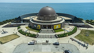
The Adler Planetarium is a public museum in Chicago, Illinois, dedicated to astronomy and astrophysics. It was founded in 1930 by local businessman Max Adler. Located on the northeastern tip of Northerly Island on Lake Michigan, the Adler Planetarium was the first planetarium in the United States. It is part of Chicago's Museum Campus, which includes the John G. Shedd Aquarium and The Field Museum. The Planetarium's mission is to inspire exploration and understanding of the universe.
Celestia is a real-time 3D astronomy software program that was created in 2001 by Chris Laurel. The program allows users to virtually travel through the universe and explore celestial objects that have been catalogued. Celestia also doubles as a planetarium, but the user is not restricted to the Earth's surface, like in other planetarium software such as Stellarium. Celestia can display objects of various scales using OpenGL.
Observational astronomy is a division of astronomy that is concerned with recording data about the observable universe, in contrast with theoretical astronomy, which is mainly concerned with calculating the measurable implications of physical models. It is the practice and study of observing celestial objects with the use of telescopes and other astronomical instruments.
The Sloan Digital Sky Survey or SDSS is a major multi-spectral imaging and spectroscopic redshift survey using a dedicated 2.5-m wide-angle optical telescope at Apache Point Observatory in New Mexico, United States. The project began in 2000 and was named after the Alfred P. Sloan Foundation, which contributed significant funding.
NASA WorldWind is an open-source virtual globe. According to the website, "WorldWind is an open source virtual globe API. WorldWind allows developers to quickly and easily create interactive visualizations of 3D globe, map and geographical information. Organizations around the world use WorldWind to monitor weather patterns, visualize cities and terrain, track vehicle movement, analyze geospatial data and educate humanity about the Earth." It was first developed by NASA in 2003 for use on personal computers and then further developed in concert with the open source community since 2004. As of 2017, a web-based version of WorldWind is available online. An Android version is also available.
Google Earth is a computer program that renders a 3D representation of Earth based primarily on satellite imagery. The program maps the Earth by superimposing satellite images, aerial photography, and GIS data onto a 3D globe, allowing users to see cities and landscapes from various angles. Users can explore the globe by entering addresses and coordinates, or by using a keyboard or mouse. The program can also be downloaded on a smartphone or tablet, using a touch screen or stylus to navigate. Users may use the program to add their own data using Keyhole Markup Language and upload them through various sources, such as forums or blogs. Google Earth is able to show various kinds of images overlaid on the surface of the Earth and is also a Web Map Service client. In 2019, Google revealed that Google Earth now covers more than 97 percent of the world, and has captured 10 million miles of Street View imagery.
A virtual globe is a three-dimensional (3D) software model or representation of Earth or another world. A virtual globe provides the user with the ability to freely move around in the virtual environment by changing the viewing angle and position. Compared to a conventional globe, virtual globes have the additional capability of representing many different views of the surface of Earth. These views may be of geographical features, man-made features such as roads and buildings, or abstract representations of demographic quantities such as population.
The Rose Center for Earth and Space is a part of the American Museum of Natural History in New York City. The Center's complete name is The Frederick Phineas and Sandra Priest Rose Center for Earth and Space. The main entrance is located on the northern side of the museum on 81st Street near Central Park West in Manhattan's Upper West Side. Completed in 2000, it includes the new Hayden Planetarium, the original of which was opened in 1935 and closed in 1997. Neil deGrasse Tyson is its first and, to date, only director.
Sky-Map.org is a wiki and interactive sky map that covers more than half a billion celestial objects. Users can view the whole star sky at once and zoom in to view areas in greater detail. WikiSky includes many stars, galaxies, constellations, and planets, but it is still in development. Users can also edit information about different stars by writing articles, adding Internet links, uploading images, or create a special interest group for a specific task. The website, although still available for users to visit, has not shown much activity since 2010.
Observatory Robert A. Naef is an astronomical observatory located at Épendes, Canton of Fribourg, Switzerland at 7.13938 degrees east of Greenwich and 46.76236 degrees north latitude. Its parallax constants are : ρ sin φ' = 0.68632 and ρ cos φ' = +0.72501.
Digital Universe Atlas is a free open source software planetarium application, available under the terms of the Illinois Open Source License, and running on Linux, Windows, macOS, AmigaOS 4, and IRIX.
SpaceEngine is an interactive 3D planetarium and astronomy software developed by Russian astronomer and programmer Vladimir Romanyuk. It creates a 1:1 scale three-dimensional planetarium representing the entire observable universe from a combination of real astronomical data and scientifically accurate procedural generation algorithms. Users can travel through space in any direction or speed, and forwards or backwards in time. SpaceEngine is in beta status and up to version 0.9.8.0E, released in August 2017, it was available as a freeware download for Microsoft Windows. Version 0.990 beta was the first paid edition, released in June 2019 on Steam. The program has full support for VR headsets.
Nightshade is a simulation and visualization software for teaching and exploring astronomy, Earth science, and related topics. Its focus is on use in digital planetarium systems or as an educational tool, with additional features to allow it to also be used on desktop or laptop computers. It operates on Linux, macOS and Windows.
glue is an interactive linked-view data visualization package for exploring relationships within and between related datasets.
This page is based on this Wikipedia article Text is available under the CC BY-SA 4.0 license; additional terms may apply. Images, videos and audio are available under their respective licenses.