Água de Pau

Last updated
Água de Pau
Civil Parish ( Freguesia )
Praia de Agua de Pau - Lagoa (Portugal).jpg
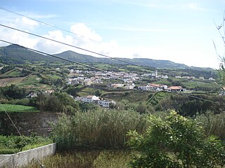
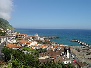
A view of Baixo da Areia beach along the southern coastal area, separated from the village of Caloura
Official name:Freguesia de Água de Pau
Name origin: Portuguese for water of wood
Country Flag of Portugal.svg  Portugal
Autonomous Region Flag of the Azores.svg  Azores
Island São Miguel
Municipality Lagoa
Localities Água de Pau,Caloura, Cerco,Cinzeiro,Galera,Jubileu
Landmark Convent of Caloura
Center Água de Pau
 - elevation 103 m (338 ft)
 - coordinates 37°43′16″N25°30′38″W / 37.72111°N 25.51056°W / 37.72111; -25.51056 Coordinates: 37°43′16″N25°30′38″W / 37.72111°N 25.51056°W / 37.72111; -25.51056
Highest point Pico da Barrosa
 - location Água de Pau Massif
 - elevation 922 m (3,025 ft)
 - coordinates 37°45′36″N25°29′29″W / 37.76000°N 25.49139°W / 37.76000; -25.49139
Lowest point Sea level
 - location Atlantic Ocean
 - elevation 0 m (0 ft)
Area 17.46 km2 (7 sq mi)
 - urban .40 km2 (0 sq mi)
Population 3,058 (2011)
Density 175/km2 (453/sq mi)
Settlement c. 1414
 -  Parish 28 July 1500
 -  Civil Parish c. 1515
LAU Junta Freguesia
 - location Largo de Santiago
President Junta Roberto Manuel Pereira de Sousa
President Assembleia Mónica Isabel Barranqueiro Domingues
Timezone Azores (UTC-1)
 - summer (DST) Azores (UTC0)
Postal Zone 9560-217
Area Code & Prefix (+351) 292 XX XX XX
Patron Saint Nossa Senhora dos Anjos
Locator map AZO SMG LAG Agua de Pau.svg
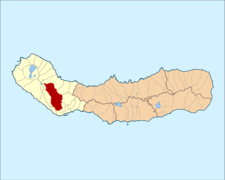
The location of the civil parish of Água de Pau within the municipality of Lagoa
Wikimedia Commons: Água de Pau (Lagoa)

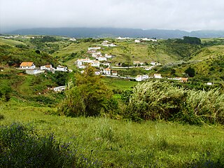
Água de Pau is a civil parish in the municipality of Lagoa in the Portuguese archipelago of the Azores. The population in 2011 was 3,058, [1] in an area of 17.46 km². [2]

Concelho, is the Portuguese-language term for municipality, referring to the territorial division. In comparison, the word município refers to the organs of State. This differentiation is still in use in Portugal and some of its former overseas provinces, but is no longer in use in Brazil following the abolition of these organs, in favour of the French prefecture system.

Portugal Republic in Southwestern Europe

Portugal, officially the Portuguese Republic, is a country located mostly on the Iberian Peninsula in southwestern Europe. It is the westernmost sovereign state of mainland Europe. It is bordered to the west and south by the Atlantic Ocean and to the north and east by Spain. Its territory also includes the Atlantic archipelagos of the Azores and Madeira, both autonomous regions with their own regional governments.

Azores Portuguese archipelago in the North Atlantic Ocean

The Azores, officially the Autonomous Region of the Azores, is one of the two autonomous regions of Portugal. It is an archipelago composed of nine volcanic islands in the North Atlantic Ocean about 1,360 km (850 mi) west of continental Portugal, about 1,643 km (1,021 mi) west of Lisbon, in continental Portugal, about 1,507 km (936 mi) northwest of Morocco, and about 1,925 km (1,196 mi) southeast of Newfoundland, Canada.

Contents

History

The front facade of Nossa Senhora dos Anjos, along the Regional Road in the center of Agua de Pau, Lagoa Igreja de Nossa Sehora dos Anjos, fachada, Agua de Pau, Lagoa, ilha de Sao Miguel, Acores.JPG
The front facade of Nossa Senhora dos Anjos, along the Regional Road in the center of Água de Pau, Lagoa

There are various theories as to the origin of the villa's name, Água de Pau, which literally means water of wood (which can be interpreted as waters where wood exist). The most recognized story pertains to early settlers whom, upon arriving in the vicinity of the coast, noticed a large ravine emptying into the ocean from a swamp. Another story defended locally is that the name derived from the corruption of the phrase "Água do Paul" (paul possibly being a term for swamp or bog), which itself referred to the "Ribeira do Paul", an old ravine that existed in the area behind the older parochial church of Nossa Senhora dos Anjos. The Paul has long since disappeared, and the area behind the church has been cultivated over the decades. Nossa Senhora dos Anjos dos Céus was founded, as was the custom, in the center of the faith community and it is likely that this area was an initial settlement for the community.

Swamp A forested wetland

A swamp is a wetland that is forested. Many swamps occur along large rivers where they are critically dependent upon natural water level fluctuations. Other swamps occur on the shores of large lakes. Some swamps have hammocks, or dry-land protrusions, covered by aquatic vegetation, or vegetation that tolerates periodic inundation or soil saturation. The two main types of swamp are "true" or swamp forests and "transitional" or shrub swamps. In the boreal regions of Canada, the word swamp is colloquially used for what is more correctly termed a bog, fen, or muskeg. The water of a swamp may be fresh water, brackish water or seawater. Some of the world's largest swamps are found along major rivers such as the Amazon, the Mississippi, and the Congo.

Bog wetland that accumulates peat due to incomplete decomposition of plant leftovers

A bog is a wetland that accumulates peat, a deposit of dead plant material—often mosses, and in a majority of cases, sphagnum moss. It is one of the four main types of wetlands. Other names for bogs include mire, quagmire, and muskeg; alkaline mires are called fens. They are frequently covered in ericaceous shrubs rooted in the sphagnum moss and peat. The gradual accumulation of decayed plant material in a bog functions as a carbon sink.

What is known, is that the settlement is concentrated around this church (dating back to about 1444) owing to the abundance of potable water and fertile lands. On 28 July 1515, the parish was incorporated, and the administration elevated, to the status of vila (town) by King D. Manuel I; this municipal seat, its territory comprising about a half a league of land, was de-annexed from the neighboring territory of Vila Franca do Campo. [3]

Manuel I of Portugal Portuguese monarch

Dom Manuel I, the Fortunate, King of Portugal and the Algarves, was the son of Ferdinand, Duke of Viseu, by his wife, the Infanta Beatrice of Portugal. His name is associated with a period of Portuguese history distinguished by significant achievements both in political affairs and in the arts. In spite of Portugal’s small size and population in comparison to the great European land powers of France, Italy and even Spain, the classical Portuguese Armada was the largest in the world at the time. During Manuel's reign Portugal was able to acquire an overseas empire of vast proportions, the first in world history to reach global dimensions. The landmark symbol of the period was the Portuguese discovery of Brazil and the South American subcontinent in April 1500.

Vila Franca do Campo Municipality in Azores, Portugal

Vila Franca do Campo is a town and municipality in the southern part of the island of São Miguel in the Portuguese Autonomous Region of the Azores. The population of the municipality was 11,229 in 2011, in an area of 77.97 km². The town proper, which incorporates the urbanized parishes São Miguel and São Pedro, has 4100 inhabitants.

Its urban nucleus, with its narrow streets, are typical of the colored houses, flowered avenues and traditional homes of the older buildings of Portugal, but following the 1522 Vila Franca earthquake many of these homes were destroyed: reconstruction was completed on 10 November 1525.

The 1522 Vila Franca earthquake, alternately the 1522 Vila Franca landslide refers to the great earthquake and landslides that occurred between 21–22 October 1522, in the municipality of Vila Franca do Campo, on the island of São Miguel, in the Portuguese archipelago of the Azores.

Its administrative role lasted for 330 years, until 24 June 1853, when the parish was incorporated into the municipality of Lagoa, while still retaining the honorific vila title (under Regional Legislative Decree 29/2003/A), to function as a civil parish.

Geography

A view of the parish of Agua de Pau, as seen from the coast, along the slopes of the Agua de Pau massif Agua de Pau, Azores.jpg
A view of the parish of Água de Pau, as seen from the coast, along the slopes of the Água de Pau massif
The compact streets that wind around the main center of Agua de Pau Aqua de Pau, Street view.jpg
The compact streets that wind around the main center of Água de Pau

The town of Água de Pau is located along the southern coast of the island of São Miguel, approximately 7 kilometres (4.3 mi) from the municipal center of Lagoa. It is bordered on either frontier by the Lagoan parishes of Santa Cruz (to the west) and Ribeira Chã (to the east), and fronts the Atlantic Ocean to the south. The interior headlands form part of the Água de Pau Massif, the central volcanic complex that formed the municipality and central portion of the island. This area is a shared frontier with the parishes of Santa Bárbara and Ribeira Seca in the municipality of Ribeira Grande (to the north) and Água de Alto (to the east) in the municipality of Vila Franca do Campo.

São Miguel Island Island in Azores, Portugal

São Miguel Island, nicknamed "The Green Island", is the largest and most populous island in the Portuguese archipelago of the Azores. The island covers 760 km2 (290 sq mi) and has around 140,000 inhabitants, with 45,000 people resident in Ponta Delgada, the archipelago's largest city.

Santa Cruz is a parish in the municipality of Lagoa in the Azores. The population in 2011 was 3,671, in an area of 14.27 km².

Ribeira Chã Civil Parish in Azores, Portugal

Ribeira Chã is a civil parish in the municipality of Lagoa in the Portuguese archipelago of the Azores. It is located along a cliff that overlooks the Atlantic Ocean. The population in 2011 was 396, in an area of 2.50 km². Ribeira Chã is the smallest parish by population and area in the municipality of Lagoa.

The territory is bisected by the Via-Rapida that transits the territory from Ponta Delgada to Vila Franca do Campo, but also by an older municipal roadway that connects the villages of the municipality, while rural roads intersperse these areas.

Architecture

The village has a rich architectural history, and can be seen in many of the civil and religious buildings erected over the centuries. The water fountains are particularly important vestiges of the historical community. To many of the local residents, these fountains were the sources of water, and centers of community meetings and fraternization. The main Chafariz de Água de Pau, located in the Largo de São Pedro, the fountain Praça da Republica and the water fountain of Nossa Senhora dos Anjos were important markers of community life within the villa.

Civic

Portuguese language Romance language that originated in Portugal

Portuguese is a Western Romance language originating in the Iberian Peninsula. It is the sole official language of Portugal, Brazil, Cape Verde, Guinea-Bissau, Mozambique, Angola, and São Tomé and Príncipe. It also has co-official language status in East Timor, Equatorial Guinea and Macau in China. As the result of expansion during colonial times, a cultural presence of Portuguese and Portuguese creole speakers are also found in Goa, Daman and Diu in India; in Batticaloa on the east coast of Sri Lanka; in the Indonesian island of Flores; in the Malacca state of Malaysia; and the ABC islands in the Caribbean where Papiamento is spoken, while Cape Verdean Creole is the most widely spoken Portuguese-based Creole. A Portuguese-speaking person or nation may be referred to as "Lusophone" in both English and Portuguese.

Religious

Front facade of the chapel annex of the Convent of Caloura, dedicated to Nossa Senhora das Dores, Caloura, Lagoa Fachada da Igreja do Convento da Caloura, Lagoa, ilha de Sao Miguel, Acores.JPG
Front facade of the chapel annex of the Convent of Caloura, dedicated to Nossa Senhora das Dores, Caloura, Lagoa

Culture

Festivities

Água de Pau's principal festival occurs on the assumption day of Nossa Senhora dos Anjos aos Céus, on August 15: the second oldest religious festival on the island of São Miguel. Locals and tourists participate in the event, that includes promessas, petitions to the Virgin Mary and prayers of thanksgiving. A traditional procession runs through the streets of the villa, showing the devotion and faith of the local community. In the following weekend, the traditional Festa do Pescador (Fisherman's Festival) in the seaside resort of Caloura is celebrated. In addition to music and traditional choruses, the popular local cuisine is celebrated with fried Largehead hairtail and mackerel, washed-down with local red wine and accompanied with corn bread. The feast day of Nossa Senhora das Dores is also widely celebrated, on the second or third Sunday in September.

The town also participates in the annual Festivals of the Divine Holy Spirit, celebrated in its six principal impérios or religious niche/chapels: the Império da Festa, the Império da Trindade, the Império de São João, the Império do Coração de Jesus, the Império de São Pedro and the Império de São Tiago.

Celebrations to honor the elevation of Água de Pau to the status of villa, on July 28, are also popular in the community and celebrated in the Largo de São Tiago and Casa da Junta (the parish house).

Related Research Articles

Belver (Gavião) Civil parish in Alentejo, Portugal

Belver is a Portuguese civil parish in the municipality of Gavião, district of Portalegre. The population in 2011 was 684, in an area of 69.84 km². It is situated along the northern bank of the Tagus River.

Vila do Porto Municipality in Azores, Portugal

Vila do Porto is the single municipality, the name of the main town and one of the civil parishes on the island of Santa Maria, in the Portuguese archipelago of Azores. Its nearest neighbor, administratively, is the municipality of Povoação on the southern coast of São Miguel, and it is physically southwest of the islets of the Formigas. The population in 2011 was 5,552, in an area of 96.89 km².

Angra do Heroísmo Municipality in Azores, Portugal

Angra do Heroísmo, generally known as Angra, is a municipality and city on the island of Terceira in the Portuguese autonomous region of the Azores. The population in 2011 was 35,402, in an area of 239.00 km². It forms the southern half of Terceira, with the north belonging to Praia da Vitória. Together with Ponta Delgada on São Miguel and Horta on Faial, Angra is one of the three regional capitals of the Azores. Each capital is responsible for one of the three branches of government. It is also the location of the Azorean bishop.

Calheta, Azores Municipality in Azores, Portugal

Calheta is a municipality on the island of São Jorge, in the Portuguese autonomous region of Azores. The municipality includes the eastern portion of the island of São Jorge and borders the municipality of Velas. The population in 2011 was 3,773, in an area of 126.26 km².

Feteira (Angra do Heroísmo) Civil Parish in Azores, Portugal

Feteira is a rural civil parish in the municipality of Angra do Heroísmo in the Portuguese archipelago of the Azores. The population in 2011 was 1,239, in an area of 5.25 square kilometres (2.03 sq mi).

Serreta (Angra do Heroísmo) Civil Parish in Azores, Portugal

Serreta is a civil parish in the municipality of Angra do Heroísmo on the island of Terceira in the Portuguese archipelago of the Azores. Its elevation is approximately 471 metres (1,545 ft). The population in 2011 was 335, in an area of 14.36 km2. It is the smallest parish in the municipality by population.

Vila de São Sebastião Civil Parish in Azores, Portugal

Vila de São Sebastião, commonly shortened to São Sebastião, is a civil parish in the municipality of Angra do Heroísmo, on the island of Terceira in the Portuguese archipelago of the Azores. The population in 2011 was 2,096, in an area of 23.93 square kilometres (9.24 sq mi). It is in the southeastern part of the island of Terceira.

Arrifes civil parish in Ponta Delgada

Arrifes is a civil parish in the municipality of Ponta Delgada on the island of São Miguel in the Azores. The population in 2011 was 7,086, in an area of 25.37 km².

São José (Ponta Delgada) Civil Parish in Azores, Portugal

São José is a civil parish in the municipality of Ponta Delgada on the island of São Miguel in the Portuguese archipelago of the Azores. It is one of the constituent parts of the city of Ponta Delgada, and location of many of the island's more significant cultural and historical, commercial and residential buildings. Extending a short distance along the coast it, nevertheless includes a large mixed urban-rural constituency from the shore north to the main freeway, the Via-Rápida. The population in 2011 was 5,934, in an area of 1.66 km².

Lagoa, Azores Municipality in Azores, Portugal

Lagoa is a municipality in the southwestern part of São Miguel Island in the Azores. The population in 2011 was 14,442, in an area of 45.59 km². Lagoa is located east of Ponta Delgada, the island capital.

Povoação, Azores Municipality in Azores, Portugal

Povoação is a municipality located in the southeastern corner of the island of São Miguel in the Portuguese archipelago of the Azores. The population in 2011 was 6,327, in an area of 106.41 km².

Almagreira (Vila do Porto) Civil Parish in Azores, Portugal

Almagreira is a civil parish in the municipality of Vila do Porto on the island of Santa Maria, in the Portuguese autonomous region of Azores. The population in 2011 was 599, in an area of 11.22 km². Bordering all other parishes of the island, it is located northwest of Vila do Porto.

Santo Espírito Civil Parish in Azores, Portugal

Santo Espírito is a Portuguese civil parish, located in the municipality of Vila do Porto, in the autonomous region of Azores. The population in 2011 was 588, in an area of 26.68 km².

Alandroal Municipality in Alentejo, Portugal

Alandroal is a municipality in the Portuguese district of Évora located on the eastern frontier with Spain along the right margin of the Guadiana River in the Central Alentejo region. It is located 341 metres (1,119 ft) above sea level, northeast of Évora and southeast of Estremoz. The population in 2011 was 5,843, in an area of 542.68 km².

Vila do Porto (parish) Civil Parish in Azores, Portugal

Vila do Porto is a civil parish in the municipality of Vila do Porto, located on the island of Santa Maria, in the Portuguese autonomous region of Azores. It is the southernmost and easternmost parish in the archipelago of Azores. The population in 2011 was 3,119, in an area of 25.55 km².

Guia (Albufeira) Civil parish in Algarve, Portugal

Guia is a civil parish in the Portuguese municipality of Albufeira in the Algarve, 5 kilometres (3.1 mi) from the coast. The population in 2011 was 4,376, in an area of 26.80 km².

Nossa Senhora do Bispo is a former civil parish in the municipality of Montemor-o-Novo, Portugal. In 2013, the parish merged into the new parish Nossa Senhora da Vila, Nossa Senhora do Bispo e Silveiras. It has an area of 121.83 km², and a population of approximately 5411 inhabitants in 2001 (approximately 44 inhabitants per km².

Povoação (parish) Civil parish in Azores, Portugal

Povoação is a civil parish in the municipality (concelho) of Povoação, on the island of São Miguel in the Portuguese archipelago of the Azores. The population in 2011 was 2,161, in an area of 26.23 km².

References

Notes

  1. Instituto Nacional de Estatística
  2. Eurostat
  3. 1 2 3 4 5 6 Noé, Paula (2012). SIPA, ed. "Convento da Caloura/Recolhimento da Caloura (no.PT072101010007)" (in Portuguese). Lisbon, Portugal: SIPA – Sistema de Informação para o Património Arquitectónico. Retrieved 25 August 2012.
  4. 1 2 3 Noé, Paula (2011). SIPA, ed. "Igreja Paroquial de Água de Pau/Igreja de Nossa Senhora dos Anjos (IPA.00032456/PT072101010019)" (in Portuguese). Lisbon, Portugal: SIPA – Sistema de Informação para o Património Arquitectónico. Retrieved 16 April 2014.
  5. 1 2 3 Noé, Paula (2013). SIPA, ed. "Ermida de Nossa Senhora do Monte (IPA.00034706)" (in Portuguese). Lisbon, Portugal: SIPA – Sistema de Informação para o Património Arquitectónico. Retrieved 16 April 2014.
  6. Noé, Paula (2013). SIPA, ed. "Ermida de São Tiago (IPA.00034707)" (in Portuguese). Lisbon, Portugal: SIPA – Sistema de Informação para o Património Arquitectónico. Retrieved 16 April 2014.