Leochares was an ancient Greek sculptor from Athens, who lived in the 4th century BC.

Indre By, also known as Copenhagen Center or K or Downtown Copenhagen, is an administrative district (bydel) in central Copenhagen, the capital of Denmark. It covers an area of 4.65 square kilometres (1.80 sq mi), has a population of 26,223, and a population density of 5,638 per km².

Vesterbro is one of the 15 administrative, statistical, and city tax districts (bydele) comprising the municipality of Copenhagen, Denmark. It covers an area of 3.76 km2 (1.45 sq mi), and has a population of 51,466 and a population density of 13,688 per km2.

Louis Hasselriis was a Danish sculptor known for his public statuary.
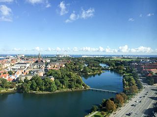
Copenhagen is a green city well endowed with open spaces. It has an extensive and well-distributed system of parks that act as venues for a wide array of events and urban life. As a supplement to the regular parks, there are a number of congenial public gardens and some cemeteries doubling as parks. It is official municipal policy in Copenhagen that all citizens by 2015 must be able to reach a park or beach on foot in less than 15 minutes.

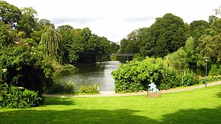
Østre Anlæg is a public park in Copenhagen. Once it was a part of the old city fortifications. The park was designed by landscape architect H.A. Flindt who also designed Ørstedsparken and Copenhagen Botanical Garden on the old fortification. The park lies between The National Art Museum at the southern end, and Oslo Plads and Østerport Station at the northern end. There are three lakes in this park, they used to be part of the moat system.

The fortifications of Copenhagen underwent a comprehensive modernization and expansion in the 17th century. The project was commenced and was largely the masterplan of Christian IV in the early 17th century but was continued and completed by his successors. The new fortifications relied on the existing, medieval fortifications of the city but the fortified area was extended and a defensive ring around the city completed particularly with new edifices facing the sea. The ring fortification consisted of four bastioned ramparts and an annexed citadel as well as various outworks.

The Fortification Ring in Copenhagen, Denmark, is a collective name used to refer to the grounds where the city's old 17th-century fortifications used to lie, now surrounding the City Centre. Since the fortifications were decommissioned in 1870, the Fortification Ring has been dominated by a number of parks and distinctive greenspaces and it is still maintained and developed as a green belt within the city limits, running between the city centre and the -bro districts. The ramparts, bastions and moats of the former fortifications are still clearly seen in the topography. At Christianshavn and the citadel Kastellet, the fortifications have been preserved and remain intact.
Christianshavns Vold is a former rampart which was part of the bastioned fortification ring which used to surround Copenhagen, Denmark. Running along the full south-eastern perimeter of Christianshavn and Holmen, it used to form a protective barrier towards the island of Amager. It consists of earthworks with 12 bastions and in front of it ran a moat, Stadsgraven, now forming a broad canal which separates Christianshavn from the rest of Amager. On the other side of Stadsgraven. on Amager, was a lower system of outworks called Christianshavns Enveloppe of which only the northern half survives. Along with Kastellet on the other side of the harbour, it is the only intact part of the fortification system.

Churchillparken is a public park in Copenhagen, Denmark, occupying a tract of land between Kastellet, a 17th-century fortress, and the street Esplanaden. Located on the former esplanade which used to surround Kastellet, the area has a long history as a greenspace but received its current name in 1965 to commemorate Winston Churchill and the British assistance in the liberation of Denmark during World War II.

The Ivar Huitfeldt Column is a monument at Langelinie in Copenhagen, Denmark, built to commemorate the death of Admiral Ivar Huitfeldt and his men from HDMS Dannebroge, which exploded and sank in the Battle of Køge Bat during the Great Northern War. The monument was constructed in 1886 to a design by Vilhelm Dahlerup. Ferdinand Edvard Ring was responsible for the statue of the Roman goddess of victory, Victoria, and for the reliefs, while Carl Brummer undertook the monument's architectural design.

Israels Plads is a large public square in central Copenhagen, Denmark, located in the area between Nørreport station and The Lakes. Its northern part hosts a market. Its southern part was extensively redesigned in 2014, with transition into the adjacent Ørsted Park.
Frue Plads is a public square located on the north side of the Church of Our Lady in central Copenhagen, Denmark. It occupies a rectangular space which is bounded on the other sides by University of Copenhagen's main building to the north, Nørregade to the west and pedestrianized Fiolstræde to the east.

Vester Farimagsgade, Nørre Farimagsgade and Øster Farimagsgade is a succession of streets which together connect the south-western Vesterbro to the northern Østerbro along the periphery of the city centre in Copenhagen, Denmark. A continuation of Reventlowsgade, Vester Farimagsgade extends from Vesterbrogade at Vesterport Station and initially runs along the sunken railway tracks on the left before soon reaching H. C. Andersens Boulevard. It then turns into Nørre Farimagsgade and continues behind Ørsted Park to Gothersgade where it becomes Øster Farimagsgade and proceeds along another green space, the Copenhagen Botanical Garden, passes Sølvtorvet and the neighbourhood of terraced houses known as Kartoffelrækkerne before terminating at Lille Triangel where Østerbrogade begins.
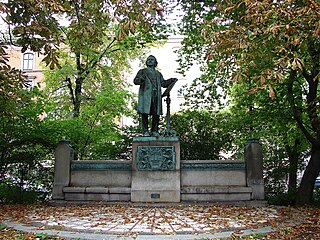
The Physicist Hans Christian Ørsted is a monument to Hans Christian Ørsted located in Ørsted Park in central Copenhagen, Denmark.

The Dragon Fountain is a fountain located in the City Hall Square in Copenhagen, Denmark. It was designed by Joakim Skovgaard in collaboration with Thorvald Bindesbøll and features a bull in combat with a dragon.

Rosenørns Allé is a street located on the border between Frederiksberg and Nørrebro, on the west side of The Lakes, in Copenhagen, Denmark. The street branches from the south side of the busy thoroughfare Kampmannsgade-Åboulevard at the west end of the embankment which separates St. Jørgen's Lake from Peblinge Lake, runs west to Julius Thomsens Plads and then continues in a more northwesterly direction to Bülowsvej where it turns into Rolighedsvej and later Godthåbsvej before reaching Bellahøj in Brønshøj.

Jagtvej is a major artery in the Nørrebro and Østerbro districts of Copenhagen, Denmark. It runs from Ågade on the border with Frederiksberg in the southwest to Østerbrogade in the northeast, linking Falkoner Allé with Strandboulevarden. The street passes Assistens Cemetery, University of Copenhagen's North Campus and Fælled Park.
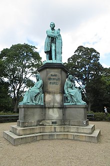
The Statue of Niels W. Gade is a statue of Danish composer Niels W. Gade located in Østre Anlæg in Copenhagen, Denmark. It depicts Gade in the process of conducting Elverskud, one of his most famous works. The monument was originally located on Sankt Annæ Plads but moved to its current location in May 1934.

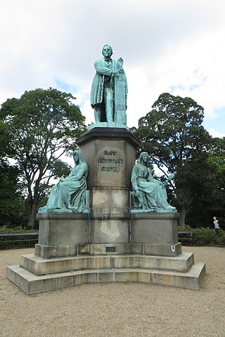
The statue of Anders Sandøe Ørsted is located in Ørstedsparken in Copenhagen, Denmark. Ørsted was Denmark's leading jurist of the mid-19th century. He served as Prime Minister of Denmark in 1853–54.