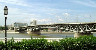
Petőfi híd or Petőfi Bridge is a bridge in Budapest, connecting Pest and Buda across the Danube. It is the second southernmost public bridge in Budapest.

The arrondissement of Nogent-sur-Marne is an arrondissement of France in the Val-de-Marne departement in the Île-de-France region. It has 14 communes.
Haraze Al Biar is one of three departments in Hadjer-Lamis, a region of Chad. Its capital is Massaguet.

Lenin Stadium is a multi-use stadium in Khabarovsk, Russia. It is currently used mostly for association football matches and is the home ground of FC SKA-Khabarovsk. The stadium holds 15,200 people. It is named after communist revolutionary Vladimir Lenin.

Chmieleń is a village in the administrative district of Gmina Lubomierz, within Lwówek Śląski County, Lower Silesian Voivodeship, in south-western Poland. It lies approximately 5 kilometres (3 mi) south-west of Lubomierz, 17 kilometres (11 mi) south-west of Lwówek Śląski, and 111 kilometres (69 mi) west of the regional capital Wrocław.
Żniatyn is a village in the administrative district of Gmina Dołhobyczów, within Hrubieszów County, Lublin Voivodeship, in eastern Poland, close to the border with Ukraine. It lies approximately 13 kilometres (8 mi) south of Dołhobyczów, 39 km (24 mi) south of Hrubieszów, and 131 km (81 mi) south-east of the regional capital Lublin.
Wielki Bór is a settlement in the administrative district of Gmina Giby, within Sejny County, Podlaskie Voivodeship, in north-eastern Poland, close to the borders with Belarus and Lithuania. It lies approximately 13 kilometres (8 mi) south of Sejny and 99 km (62 mi) north of the regional capital Białystok.

Dəcəl is a village in the Jabrayil Rayon of Azerbaijan.
Michałowice is a village in the administrative district of Gmina Czarnocin, within Kazimierza County, Świętokrzyskie Voivodeship, in south-central Poland. It lies approximately 4 kilometres (2 mi) north-west of Czarnocin, 11 km (7 mi) north of Kazimierza Wielka, and 59 km (37 mi) south of the regional capital Kielce.
Jastrzębiec is a village in the administrative district of Gmina Kuryłówka, within Leżajsk County, Subcarpathian Voivodeship, in south-eastern Poland. It lies approximately 15 kilometres (9 mi) east of Kuryłówka, 19 km (12 mi) north-east of Leżajsk, and 58 km (36 mi) north-east of the regional capital Rzeszów.
Kowala is a village in the administrative district of Gmina Pińczów, within Pińczów County, Świętokrzyskie Voivodeship, in south-central Poland. It lies approximately 7 kilometres (4 mi) south of Pińczów and 46 km (29 mi) south of the regional capital Kielce.
Strugi is a village in the administrative district of Gmina Teresin, within Sochaczew County, Masovian Voivodeship, in east-central Poland. It lies approximately 11 kilometres (7 mi) south-east of Sochaczew and 46 km (29 mi) west of Warsaw.
Sucha Huta is a village in the administrative district of Gmina Przywidz, within Gdańsk County, Pomeranian Voivodeship, in northern Poland. It lies approximately 6 kilometres (4 mi) south of Przywidz, 23 km (14 mi) south-west of Pruszcz Gdański, and 31 km (19 mi) south-west of the regional capital Gdańsk.
Sokolniki is a village in the administrative district of Gmina Maszewo, within Goleniów County, West Pomeranian Voivodeship, in north-western Poland. It lies approximately 5 kilometres (3 mi) east of Maszewo, 23 km (14 mi) east of Goleniów, and 38 km (24 mi) east of the regional capital Szczecin.
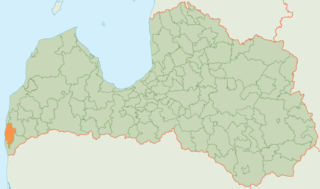
Nīca Municipality is a municipality in Courland, Latvia. The municipality was formed in 2009 by merging Nīca parish and Otaņķi parish the administrative centre being Nīca.
São José do Divino, Minas Gerais is a municipality in the state of Minas Gerais in the Southeast region of Brazil.
Kõnnu is a village in Kuusalu Parish, Harju County in northern Estonia.
Uhe is a village in Alutaguse Parish, Ida-Viru County in northeastern Estonia.
Kapra is a village in Saaremaa Parish, Saare County in western Estonia.
Tribistovo Lake is an artificial lake of Bosnia and Herzegovina. It is located in the municipality of Posusje.


