
Forestville is a census-designated place (CDP) in Schuylkill County, Pennsylvania, United States. The population was 431 at the 2000 census.

Hedge End railway station is situated on the northern edge of the town of Hedge End in Hampshire, England. The station was opened by British Rail in 1990. It is 76 miles 76 chains (123.8 km) down the line from London Waterloo.
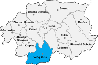
Závada is a village and municipality in the Veľký Krtíš District of the Banská Bystrica Region of southern Slovakia.
Kościelniki Dolne is a village in the administrative district of Gmina Lubań, within Lubań County, Lower Silesian Voivodeship, in south-western Poland.

Vardenut is a town in the Aragatsotn Province of Armenia. The town was settled in 1829 by emigrants from Persia as part of the exchange of populations under the Treaty of Turkmenchay.

Podlesie is a village in the administrative district of Gmina Biała Rawska, within Rawa County, Łódź Voivodeship, in central Poland. It lies approximately 7 kilometres (4 mi) north of Biała Rawska, 19 km (12 mi) north-east of Rawa Mazowiecka, and 70 km (43 mi) east of the regional capital Łódź.
Żarnowica is a village in the administrative district of Gmina Gołcza, within Miechów County, Lesser Poland Voivodeship, in southern Poland. It lies approximately 5 kilometres (3 mi) south of Gołcza, 11 km (7 mi) south-west of Miechów, and 26 km (16 mi) north of the regional capital Kraków.
Majdan Ruszowski is a village in the administrative district of Gmina Łabunie, within Zamość County, Lublin Voivodeship, in eastern Poland. It lies approximately 8 kilometres (5 mi) south-west of Łabunie, 12 km (7 mi) south of Zamość, and 87 km (54 mi) south-east of the regional capital Lublin.
Podzamcze is a village in the administrative district of Gmina Nowy Korczyn, within Busko County, Świętokrzyskie Voivodeship, in south-central Poland. It lies approximately 2 kilometres (1 mi) east of Nowy Korczyn, 21 km (13 mi) south of Busko-Zdrój, and 67 km (42 mi) south of the regional capital Kielce.
Falęcin Stary is a village in the administrative district of Gmina Stopnica, within Busko County, Świętokrzyskie Voivodeship, in south-central Poland. It lies approximately 4 kilometres (2 mi) north of Stopnica, 17 km (11 mi) east of Busko-Zdrój, and 52 km (32 mi) south-east of the regional capital Kielce.
Rembieszyce is a village in the administrative district of Gmina Małogoszcz, within Jędrzejów County, Świętokrzyskie Voivodeship, in south-central Poland. It lies approximately 7 kilometres (4 mi) south of Małogoszcz, 14 km (9 mi) north of Jędrzejów, and 27 km (17 mi) south-west of the regional capital Kielce.
Klwatka Królewska is a village in the administrative district of Gmina Gózd, within Radom County, Masovian Voivodeship, in east-central Poland. It lies approximately 10 kilometres (6 mi) west of Gózd, 10 km (6 mi) east of Radom, and 95 km (59 mi) south of Warsaw.

Kalalè is a town, arrondissement, and commune in the Borgou Department of eastern Benin. The commune covers an area of 3,586 square kilometres (1,385 sq mi) and as of 2002 had a population of 100,026 people.
Nowy Świat is a village in the administrative district of Gmina Śmigiel, within Kościan County, Greater Poland Voivodeship, in west-central Poland.
Gorzków Nowy is a village in the administrative district of Gmina Niegowa, within Myszków County, Silesian Voivodeship, in southern Poland. It lies approximately 4 kilometres (2 mi) north of Niegowa, 16 km (10 mi) north-east of Myszków, and 59 km (37 mi) north-east of the regional capital Katowice.
Jasiona is a village in the administrative district of Gmina Zbrosławice, within Tarnowskie Góry County, Silesian Voivodeship, in southern Poland. It lies approximately 8 kilometres (5 mi) north-west of Zbrosławice, 14 km (9 mi) west of Tarnowskie Góry, and 34 km (21 mi) north-west of the regional capital Katowice.
Dębnik is a settlement in the administrative district of Gmina Szemud, within Wejherowo County, Pomeranian Voivodeship, in northern Poland. It lies approximately 4 kilometres (2 mi) south-east of Szemud, 15 km (9 mi) south of Wejherowo, and 27 km (17 mi) north-west of the regional capital Gdańsk.
Slampe parish is an administrative unit of the Tukums Municipality, Latvia. The administrative center is Slampe.
Aïn Ou Ksir is a town and commune in Médéa Province, Algeria. According to the 1998 census it has a population of 5,366.

The Museo d'Arte Antica is an art museum in the Castello Sforzesco of Milan, in Lombardy in northern Italy. It has a large collection of sculpture from the late antiquity, Mediaeval and Renaissance periods. The various frescoed rooms of the museum house an armoury, a tapestry room, some funerary monuments, the Rondanini Pietà and two mediaeval portals.


