Squire Park is a district in the city of Seattle, in the U.S. state of Washington. According to the Squire Park Community Council, it is bounded on the south by S. Jackson Street, on the west by 12th Avenue and 12th Avenue S., on the north by E. Union Street, and on the east by 23rd Avenue and 23rd Avenue S., placing it within what are commonly thought of as First Hill and the Central District. Its main thoroughfares are E. Jefferson and Cherry Streets and E. Yesler Way and 14th Avenue. Swedish Medical Center's Cherry Hill campus is located here, Seattle University, a Jesuit University has part of its campus in Squire Park, as the Admissions, some dormitories and Athletics departments are east of 12th Avenue.
Gjorče Petrov Stadium is a multi-use stadium in Skopje, North Macedonia. It is currently used mostly for football matches and is the home of FK Makedonija Gjorče Petrov. The stadium seats 3,000 people.

Budai Township is an urban township in Chiayi County, Taiwan.
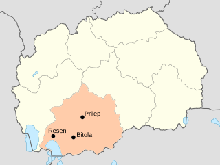
The Pelagonia Statistical Region is one of eight statistical regions of North Macedonia. It is located in southwestern part of the country along the eponymous plain. It borders Greece and Albania. Internally, it borders the Southwestern and Vardar statistical regions.

Nurnus, is a village in the Kotayk Province of Armenia.

Dyle is a village in the administrative district of Gmina Biłgoraj, within Biłgoraj County, Lublin Voivodeship, in eastern Poland. It lies approximately 8 kilometres (5 mi) north-east of Biłgoraj and 74 km (46 mi) south of the regional capital Lublin.

Taxtabaşı is a village in the Kalbajar Rayon of Azerbaijan.
Daran is a village in the Bilasuvar Rayon of Azerbaijan.
Majków Mały is a village in the administrative district of Gmina Grabica, within Piotrków County, Łódź Voivodeship, in central Poland. It lies approximately 14 kilometres (9 mi) north-east of Grabica, 24 km (15 mi) north of Piotrków Trybunalski, and 23 km (14 mi) south-east of the regional capital Łódź.
Łanowe Sołtysy is a village in the administrative district of Gmina Tarnawatka, within Tomaszów Lubelski County, Lublin Voivodeship, in eastern Poland.
Rogóźno-Kolonia is a village in the administrative district of Gmina Tomaszów Lubelski, within Tomaszów Lubelski County, Lublin Voivodeship, in eastern Poland.
Lipnik is a village in the administrative district of Gmina Kije, within Pińczów County, Świętokrzyskie Voivodeship, in south-central Poland. It lies approximately 2 kilometres (1 mi) east of Kije, 9 km (6 mi) north-east of Pińczów, and 31 km (19 mi) south of the regional capital Kielce.
Holendry Kozienickie is a village in the administrative district of Gmina Kozienice, within Kozienice County, Masovian Voivodeship, in east-central Poland. It lies approximately 4 kilometres (2 mi) north-east of Kozienice and 80 km (50 mi) south-east of Warsaw.
Miłowice is a village in the administrative district of Gmina Biała, within Prudnik County, Opole Voivodeship, in south-western Poland. It lies approximately 5 kilometres (3 mi) west of Biała Prudnicka, 9 km (6 mi) north of Prudnik, and 39 km (24 mi) south-west of the regional capital Opole.
Julin is a settlement in the administrative district of Gmina Iława, within Iława County, Warmian-Masurian Voivodeship, in northern Poland.
Písková Lhota is a village and municipality in Mladá Boleslav District in the Central Bohemian Region of the Czech Republic. It is located 6 kilometres (3.7 mi) south of Mladá Boleslav and 46 kilometres (29 mi) northeast of Prague.

Mäeküla is a subdistrict in the district of Haabersti, Tallinn, the capital of Estonia. It has a population of 2.
Tizi N'Bechar is a town and commune in Sétif Province in north-eastern Algeria.

Anoia is a comarca (county) in central Catalonia, Spain, with its capital at Igualada.
Shah Verdi Kandi is a village in Sarajuy-ye Sharqi Rural District, Saraju District, Maragheh County, East Azerbaijan Province, Iran. At the 2006 census, its population was 171, in 29 families.


