Škocjan, Koper

Last updated
Škocjan
Sveti Tomaž (until 1955), San Canziano (Italian)
Village

Postcard of Skocjan 1903.jpg

1903 postcard of Škocjan
Slovenia location map.svg
Red pog.svg
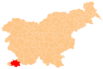
Škocjan
Location in Slovenia
Coordinates: 45°31′52.7″N13°46′30.38″E / 45.531306°N 13.7751056°E / 45.531306; 13.7751056 Coordinates: 45°31′52.7″N13°46′30.38″E / 45.531306°N 13.7751056°E / 45.531306; 13.7751056
CountryFlag of Slovenia.svg  Slovenia
Traditional region Littoral
Statistical region Coastal–Karst
Municipality Koper
Area
  Total 2.65 km2 (1.02 sq mi)
Elevation 48.2 m (158.1 ft)
Population (2002)
  Total 477
[1]

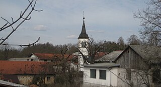
Škocjan (pronounced  [ˈʃkɔːtsjan] ) is a settlement on the outskirts of Koper in the Littoral region of Slovenia. [2]

Koper City in Slovenian Littoral, Slovenia

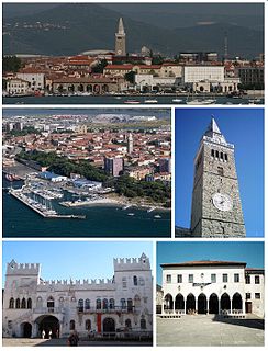
Koper is the fifth largest city in Slovenia. Located in the southwestern part of the country, approximately five kilometres south of the border with Italy and 20 kilometers from Trieste, Koper is the largest coastal city in the country. It is bordered by the satellite towns of Izola and Ankaran, and anchors the Istrian region. With a unique ecology and biodiversity, it is considered an important national natural resource. It is the oldest recorded urban settlement in Slovenia. The city's Port of Koper is the major contributor to the economy of the eponymous city municipality. With only one percent of Slovenia having a coastline, the influence that the Port of Koper also has on tourism was a factor in Ankaran deciding to leave the municipality in a referendum in 2011 to establish its own. The city is a destination on a number of Mediterranean cruising lines. In 2016, the city expects 65 cruise ship arrivals with the season spanning from March to December. Koper is the main urban centre of the Slovenian Istria, with a population of about 25,000.

Slovenia republic in Central Europe

Slovenia, officially the Republic of Slovenia, is a sovereign state located in southern Central Europe at a crossroads of important European cultural and trade routes. It is bordered by Italy to the west, Austria to the north, Hungary to the northeast, Croatia to the southeast, and the Adriatic Sea to the southwest. It covers 20,273 square kilometers (7,827 sq mi) and has a population of 2.07 million. One of the successor states of the former Yugoslavia, Slovenia is a parliamentary republic and a member of the United Nations, of the European Union, and of NATO. The capital and largest city is Ljubljana.

Contents

Name

The name of the settlement was changed from Sveti Tomaž (literally, 'Saint Thomas') to Škocjan in 1955. The name was changed on the basis of the 1948 Law on Names of Settlements and Designations of Squares, Streets, and Buildings as part of efforts by Slovenia's postwar communist government to remove religious elements from toponyms. [3] [4] [5]

Related Research Articles

Pivka Place in Inner Carniola, Slovenia

Pivka is a small town in Slovenia in the Pivka Basin in the Karst region. It is the seat of the Municipality of Pivka. It belongs to the traditional region of Inner Carniola.

Sveti Anton, Koper Place in Littoral, Slovenia

Sveti Anton is a settlement in the City Municipality of Koper in the Littoral region of Slovenia. It includes the hamlets of Boškarji, Bužarji, Cerej, Dolani, Dvori, Farančan, Fikoni, Gregoriči, Kavaliči, Kortina, Pečki, Škofarji, Sušteti, Tomažiči, Turki, and Vrtine.

Šmihel, Nova Gorica Place in Slovenian Littoral, Slovenia

Šmihel is a dispersed settlement in the Municipality of Nova Gorica in western Slovenia. It is located in the lower Vipava Valley.

Zadnja Vas in Upper Carniola, Slovenia

Zadnja Vas is a small village in the Municipality of Radovljica in the Upper Carniola region of Slovenia.

Brezje pri Tržiču Place in Upper Carniola, Slovenia

Brezje pri Tržiču is a settlement in the Municipality of Tržič in the Upper Carniola region of Slovenia. It is located near the road from Tržič to Begunje. In 2002 it had a population of 361.

Vrh pri Dolskem in Upper Carniola, Slovenia

Vrh pri Dolskem is a dispersed settlement in the hills northeast of Dolsko in the Municipality of Dol pri Ljubljani in the Upper Carniola region of Slovenia.

Vipavski Križ Place in Littoral, Slovenia

Vipavski Križ is a settlement on a small hill in the Vipava Valley in the Municipality of Ajdovščina in the Littoral region of Slovenia. It is one of the historically most interesting places in the area. There is evidence of habitation on the hill in the pre-Roman period. The settlement was first mentioned in written documents dating to the 13th century. The houses in the village are clustered inside a defence wall around a castle from the late 15th century. It was built to protect the residents against Ottoman raids. In 1532 Vipavski Križ was declared a town. In 1636 a Capuchin monastery with a rich library was founded in the town and it is now open to visitors.

Podnanos in Littoral, Slovenia

Podnanos is a village in the upper Vipava Valley in the Municipality of Vipava in the Littoral region of Slovenia. It lies below Mount Nanos, from which it gets its current name.

Slovenska Vas, Pivka Place in Inner Carniola, Slovenia

Slovenska Vas is a small village northeast of Pivka in the Inner Carniola region of Slovenia. Traditional agricultural activity of the village is linked to growing potatoes and oats and raising cattle, as well as some orchard and beekeeping activity.

Šmihel, Pivka in Inner Carniola, Slovenia

Šmihel is a village south of Pivka in the Inner Carniola region of Slovenia.

Sveti Duh, Bloke in Inner Carniola, Slovenia

Sveti Duh is a small village north of Nova Vas in the Municipality of Bloke in the Inner Carniola region of Slovenia.

Šentanel in Carinthia, Slovenia

Šentanel is a settlement in the hills northwest of Prevalje in the Carinthia region in northern Slovenia.

Kamence, Rogaška Slatina in Styria, Slovenia

Kamence is a settlement in the Municipality of Rogaška Slatina in eastern Slovenia, close to the border with Croatia. The area traditionally belonged to the region of Styria. It is now included in the Savinja Statistical Region.

Vidovica in Styria, Slovenia

Vidovica is a settlement in the Municipality of Podčetrtek in eastern Slovenia, close to the border with Croatia. The area was traditionally part of the Styria region. It is now included in the Savinja Statistical Region.

Vrhe, Trbovlje in Styria, Slovenia

Vrhe is a settlement in the Municipality of Trbovlje in central Slovenia. It lies in the hills northwest of the town of Trbovlje and part of the settlement lies in the neighbouring Municipality of Zagorje ob Savi. Traditionally the area was part of the Styria region. It is now included with the rest of the municipality in the Central Sava Statistical Region.

Gore, Hrastnik in Styria, Slovenia

Gore is a settlement in the Municipality of Hrastnik in central Slovenia. Traditionally the area was part of the Styria region. It is now included with the rest of the municipality in the Central Sava Statistical Region.

Turje, Hrastnik in Styria, Slovenia

Turje is a settlement in the hills southeast of Dol in the Municipality of Hrastnik in central Slovenia. Traditionally the area was part of the Styria region. It is now included with the rest of the municipality in the Central Sava Statistical Region.

Jelovice in Styria, Slovenia

Jelovice is a settlement in the western Haloze Hills in the Municipality of Majšperk in northeastern Slovenia. The area is part of the traditional region of Styria. It is now included with the rest of the municipality in the Drava Statistical Region.

Brnica, Žalec in Styria, Slovenia

Brnica is a small settlement in hills on the right bank of the Savinja River in the Municipality of Žalec in east-central Slovenia. The area is part of the traditional region of Styria. The municipality is now included in the Savinja Statistical Region.

Podgaj, Šentjur in Styria, Slovenia

Podgaj is a small settlement south of Ponikva in the Municipality of Šentjur in eastern Slovenia. Traditionally the area is part of Styria. The municipality is now included in the Savinja Statistical Region.

References

  1. Statistical Office of the Republic of Slovenia
  2. Koper municipal site
  3. Spremembe naselij 1948–95. 1996. Database. Ljubljana: Geografski inštitut ZRC SAZU, DZS.
  4. Premk, F. 2004. Slovenska versko-krščanska terminologija v zemljepisnih imenih in spremembe za čas 1921–1967/68. Besedoslovne lastnosti slovenskega jezika: slovenska zemljepisna imena. Ljubljana: Slavistično društvo Slovenije, pp. 113–132.
  5. Urbanc, Mimi, & Matej Gabrovec. 2005. Krajevna imena: poligon za dokazovanje moči in odraz lokalne identitete. Geografski vestnik 77(2): 25–43.