Gabrovica pri Črnem Kalu

Last updated
Gabrovica pri Črnem Kalu
Slovenia location map.svg
Red pog.svg
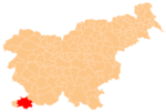
Gabrovica pri Črnem Kalu
Location in Slovenia
Coordinates: 45°33′36.42″N13°51′49.55″E / 45.5601167°N 13.8637639°E / 45.5601167; 13.8637639 Coordinates: 45°33′36.42″N13°51′49.55″E / 45.5601167°N 13.8637639°E / 45.5601167; 13.8637639
CountryFlag of Slovenia.svg  Slovenia
Traditional region Littoral
Statistical region Coastal–Karst
Municipality Koper
Area
  Total 2.53 km2 (0.98 sq mi)
Elevation 73.4 m (240.8 ft)
Population (2002)
  Total 76
[1]

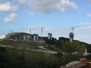
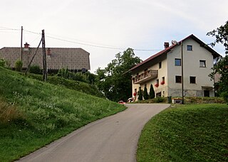
Gabrovica (pronounced  [ˈɡaːbɾɔʋitsa pɾi ˈtʃəɾnɛm ˈkaːlu] ; Italian : Gabrovizza) is a settlement near Črni Kal in the City Municipality of Koper in the Littoral region of Slovenia. [2] It lies below the Črni Kal Viaduct.

Italian language Romance language

Italian is a Romance language of the Indo-European language family. Italian, together with Sardinian, is by most measures the closest language to Vulgar Latin of the Romance languages. Italian is an official language in Italy, Switzerland, San Marino and Vatican City. It has an official minority status in western Istria. It formerly had official status in Albania, Malta, Monaco, Montenegro (Kotor) and Greece, and is generally understood in Corsica and Savoie. It also used to be an official language in the former Italian East Africa and Italian North Africa, where it plays a significant role in various sectors. Italian is also spoken by large expatriate communities in the Americas and Australia. In spite of not existing any Italian community in their respective national territories and of not being spoken at any level, Italian is included de jure, but not de facto, between the recognized minority languages of Bosnia-Herzegovina and Romania. Many speakers of Italian are native bilinguals of both standardized Italian and other regional languages.

Črni Kal Place in Littoral, Slovenia

Črni Kal is a village in southwestern Slovenia in the City Municipality of Koper. It is best known today for the Črni Kal Viaduct, the longest and the highest viaduct in Slovenia.

City Municipality of Koper Municipality in Slovenia

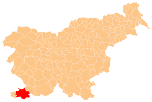
The City Municipality of Koper is one of eleven city municipalities of Slovenia. It lies at the coastline of the Adriatic Sea in southwestern Slovenia and was established in 1994. Its centre is the town of Koper. The area has been since 1995 included in Coastal–Karst Statistical Region. The municipality is bilingual.

Contents

Name

The name of the settlement was changed from Gabrovica to Gabrovica pri Črnem Kalu in 1953. [3]

Church

The local church is dedicated to Saint Nicholas and belongs to the Parish of Osp. [4]

Saint Nicholas 4th-century Christian saint

Saint Nicholas of Myra, also known as Nicholas of Bari, was an early Christian bishop of the ancient Greek maritime city of Myra in Asia Minor during the time of the Roman Empire. He is revered by many Christians as a saint. Because of the many miracles attributed to his intercession, he is also known as Nicholas the Wonderworker. Saint Nicholas is the patron saint of sailors, merchants, archers, repentant thieves, children, brewers, pawnbrokers, and students in various cities and countries around Europe. His reputation evolved among the faithful, as was common for early Christian saints, and his legendary habit of secret gift-giving gave rise to the traditional model of Santa Claus through Sinterklaas.

A parish is a territorial entity in many Christian denominations, constituting a division within a diocese. A parish is under the pastoral care and clerical jurisdiction of a parish priest, who might be assisted by one or more curates, and who operates from a parish church. Historically, a parish often covered the same geographical area as a manor. Its association with the parish church remains paramount.

Osp Place in Littoral, Slovenia

Osp is a village in the City Municipality of Koper in the Littoral region of Slovenia.

Related Research Articles

Črni Kal Viaduct bridge

The Črni Kal Viaduct is the longest and the highest viaduct in Slovenia. It is located on the A1 motorway above the Osp Valley near the village of Gabrovica, about 20 kilometres (12 mi) east of Koper. It is named after the village of Črni Kal. The viaduct is 1,065 metres (3,494 ft) long and is mounted on 11 Y-shaped columns, the highest reaching 87.5 m (287 ft).

Abitanti Place in Littoral, Slovenia

Abitanti is a small settlement in the City Municipality of Koper in the Littoral region of Slovenia.

Črnotiče Place in Littoral, Slovenia

Črnotiče is a settlement near Črni Kal in the City Municipality of Koper in the Littoral region of Slovenia. It includes the hamlets of Na Placu near St. Paul's Church, Na Vršiču in the center of the settlement, and lower-lying Na Križcah.

Dol pri Hrastovljah Place in Littoral, Slovenia

Dol pri Hrastovljah is a small village in the City Municipality of Koper in the Littoral region of Slovenia.

Klanec pri Kozini in Littoral, Slovenia

Klanec pri Kozini is a settlement south of Kozina in the Municipality of Hrpelje-Kozina in the Littoral region of Slovenia.

Brestovica pri Komnu Place in Slovenian Littoral, Slovenia

Brestovica pri Komnu is a village in the Municipality of Komen in the Littoral region of Slovenia next to the border with Italy.

Gabrovica pri Komnu Place in Slovenian Littoral, Slovenia

Gabrovica pri Komnu is a village in the Municipality of Komen in the Littoral region of Slovenia.

Kal nad Kanalom Place in Littoral, Slovenia

Kal nad Kanalom is a village in the hills east of Kanal in the Littoral region of Slovenia. It lies on the southwest part of the Banjšice Plateau.

Bača pri Podbrdu in Slovenian Littoral, Slovenia

Bača pri Podbrdu is a dispersed settlement above Podbrdo in the Municipality of Tolmin in the Littoral region of Slovenia. It lies on the southern slopes of Mount Kobla and is a popular starting point for hiking trips into the surrounding peaks of the southern Julian Alps.

Idrija pri Bači in Slovenian Littoral, Slovenia

Idrija pri Bači is a village on the right bank of the Idrijca River in the Municipality of Tolmin in the Littoral region of Slovenia.

Pečine Place in Slovenian Littoral, Slovenia

Pečine is a village in the mountains above the right bank of the Idrijca River in the municipality of Tolmin in the Littoral region of Slovenia. It includes the hamlets of Črni Vrh, Kabiunk, Kal, Maraževec, Podkal, Travnik, and Stari Rut.

Ravne pri Cerknem Village in Littoral, Slovenia

Ravne pri Cerknem is a settlement west of Cerkno in the traditional Littoral region of Slovenia.

Črni Vrh, Idrija Place in Littoral, Slovenia

Črni Vrh is a settlement in the hills south of Idrija in the traditional Littoral region of Slovenia. It includes the hamlets of Zgornja Vas, Spodnja Vas, Trate, Trebče, and Zidiše.

Nova Vas pri Jelšanah in Inner Carniola, Slovenia

Nova Vas pri Jelšanah is a small village east of Jelšane in the Municipality of Ilirska Bistrica in the Inner Carniola region of Slovenia, close to the border with Croatia.

Črni Potok pri Kočevju in Lower Carniola, Slovenia

Črni Potok pri Kočevju is a settlement southeast of the town of Kočevje in southern Slovenia. The area is part of the traditional region of Lower Carniola and is now included in the Southeast Slovenia Statistical Region.

Črni Potok pri Velikih Laščah Place in Lower Carniola, Slovenia

Črni Potok pri Velikih Laščah is a small settlement in the hills south of Velike Lašče in southern Slovenia. It lies in the Municipality of Ribnica. The entire municipality is part of the traditional region of Lower Carniola and is now included in the Southeast Slovenia Statistical Region.

Črni Potok, Šmartno pri Litiji Place in Lower Carniola, Slovenia

Črni Potok is a dispersed settlement in the valley of Black Creek south of Šmartno pri Litiji in central Slovenia. The area is part of the historical region of Lower Carniola. The entire Municipality of Šmartno pri Litiji is now included in the Central Slovenia Statistical Region. It includes the hamlets of Brezje and Sela.

Kal pri Krmelju in Lower Carniola, Slovenia

Kal pri Krmelju is a small settlement in the Municipality of Sevnica in central Slovenia. The area is part of the historical region of Lower Carniola. The municipality is now included in the Lower Sava Statistical Region.

References

  1. Statistical Office of the Republic of Slovenia
  2. Koper municipal site
  3. Spremembe naselij 1948–95. 1996. Database. Ljubljana: Geografski inštitut ZRC SAZU, DZS.
  4. Roman Catholic Diocese of Koper List of Churches May 2008 Archived March 6, 2009, at the Wayback Machine .