Škrljevo, Šentrupert

Last updated
Škrljevo
Slovenia location map.svg
Red pog.svg
Škrljevo
Location in Slovenia
Coordinates: 45°58′41.17″N15°4′41.53″E / 45.9781028°N 15.0782028°E / 45.9781028; 15.0782028 Coordinates: 45°58′41.17″N15°4′41.53″E / 45.9781028°N 15.0782028°E / 45.9781028; 15.0782028
Country Flag of Slovenia.svg Slovenia
Traditional region Lower Carniola
Statistical region Southeast Slovenia
Municipality Šentrupert
Area
  Total 1.14 km2 (0.44 sq mi)
Elevation 275.1 m (902.6 ft)
Population (2002)
  Total 82
[1]

Škrljevo (pronounced  [ʃkəɾˈljeːʋɔ] ) is a settlement just west of Šentrupert in southeastern Slovenia. The area is part of the historical region of Lower Carniola and is now included in the Southeast Slovenia Statistical Region. [2] It includes the hamlet of Češnjice (German : Kerschdorf). [3] [4]

Šentrupert Place in Lower Carniola, Slovenia

Šentrupert is a village in the traditional Lower Carniola region in southeastern Slovenia. In the past it was the cultural and economical centre of the Mirna Valley, but after the railway line bypassed the town the centre shifted to nearby Mirna. It is the seat of the Municipality of Šentrupert.

Slovenia republic in Central Europe

Slovenia, officially the Republic of Slovenia, is a sovereign state located in southern Central Europe at a crossroads of important European cultural and trade routes. It is bordered by Italy to the west, Austria to the north, Hungary to the northeast, Croatia to the southeast, and the Adriatic Sea to the southwest. It covers 20,273 square kilometers (7,827 sq mi) and has a population of 2.07 million. One of the successor states of the former Yugoslavia, Slovenia is a parliamentary republic and a member of the United Nations, of the European Union, and of NATO. The capital and largest city is Ljubljana.

Lower Carniola Traditional region in Slovenia

Lower Carniola is a traditional region in Slovenia, the southeastern part of the historical Carniola region.

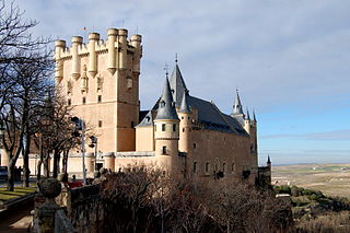
Škrljevo Castle (German : Grailach) [3] is a castle on the western edge of the settlement. It was first mentioned in written documents dating to 1044. The current building dates to the 15th and 17th centuries with some 19th-century rebuilding. [5]

German language West Germanic language

German is a West Germanic language that is mainly spoken in Central Europe. It is the most widely spoken and official or co-official language in Germany, Austria, Switzerland, South Tyrol (Italy), the German-speaking Community of Belgium, and Liechtenstein. It is also one of the three official languages of Luxembourg and a co-official language in the Opole Voivodeship in Poland. The languages which are most similar to German are the other members of the West Germanic language branch: Afrikaans, Dutch, English, the Frisian languages, Low German/Low Saxon, Luxembourgish, and Yiddish. There are also strong similarities in vocabulary with Danish, Norwegian and Swedish, although those belong to the North Germanic group. German is the second most widely spoken Germanic language, after English.

Castle Fortified residential structure of medieval Europe

A castle is a type of fortified structure built during the Middle Ages by predominantly the nobility or royalty and by military orders. Scholars debate the scope of the word castle, but usually consider it to be the private fortified residence of a lord or noble. This is distinct from a palace, which is not fortified; from a fortress, which was not always a residence for royalty or nobility; and from a fortified settlement, which was a public defence – though there are many similarities among these types of construction. Usage of the term has varied over time and has been applied to structures as diverse as hill forts and country houses. Over the approximately 900 years that castles were built, they took on a great many forms with many different features, although some, such as curtain walls and arrowslits, were commonplace.

Related Research Articles

Ortnek in Lower Carniola, Slovenia

Ortnek is a settlement in the Municipality of Ribnica in southern Slovenia. The railway line from Ljubljana to Kočevje runs through the settlement and the village has a railway station. The area is part of the traditional region of Lower Carniola and is now included in the Southeast Slovenia Statistical Region.

Gabrska Gora, Litija in Lower Carniola, Slovenia

Gabrska Gora is a settlement south of Gabrovka in the Municipality of Litija in central Slovenia. Traditionally the area was part of Lower Carniola and is now included with the rest of the municipality in the Central Sava Statistical Region; until January 2014 the municipality was part of the Central Slovenia Statistical Region. It includes the hamlets of Gora, Stari Boršt, Gabrje, and Turn.

Šentrupert, Laško in Styria, Slovenia

Šentrupert is a settlement in the Municipality of Laško in eastern Slovenia. The area was traditionally part of the Styria region. It is now included with the rest of the municipality in the Savinja Statistical Region.

Grajska Vas in Styria, Slovenia

Grajska Vas is a village in the Municipality of Braslovče in northern Slovenia. Traditionally the area was part of the Styria region. The municipality is now included in the Savinja Statistical Region.

Šentrupert, Braslovče in Styria, Slovenia

Šentrupert is a settlement in the Municipality of Braslovče in Slovenia. Traditionally the area was part of Lower Styria. The municipality is now included in the Savinja Statistical Region.

Bistrica, Šentrupert Place in Lower Carniola, Slovenia

Bistrica is a settlement in the Municipality of Šentrupert in southeastern Slovenia. The municipality is now included in the Southeast Slovenia Statistical Region. The settlement lies on the regional road leading southeast from Mirna to Mokronog in the historical region of Lower Carniola. The rail line from Sevnica to Trebnje runs south of the settlement.

Dolenje Jesenice in Lower Carniola, Slovenia

Dolenje Jesenice is a small settlement in the Municipality of Šentrupert in southeastern Slovenia. The area is part of the historical region of Lower Carniola and is now included in the Southeast Slovenia Statistical Region.

Gorenje Jesenice Place in Lower Carniola, Slovenia

Gorenje Jesenice is a village in the Municipality of Šentrupert in southeastern Slovenia. The area is part of the historical region of Lower Carniola. The municipality is now included in the Southeast Slovenia Statistical Region.

Hom, Šentrupert Place in Lower Carniola, Slovenia

Hom is a dispersed settlement in the Municipality of Šentrupert in southeastern Slovenia. The area is part of the historical region of Lower Carniola. The municipality is now included in the Southeast Slovenia Statistical Region.

Mali Cirnik pri Šentjanžu in Lower Carniola, Slovenia

Mali Cirnik pri Šentjanžu is a village in the Municipality of Šentrupert in southeastern Slovenia. It lies in the hills east of Šentrupert just off the road towards Šentjanž in the historical region of Lower Carniola. The municipality is now included in the Southeast Slovenia Statistical Region. The settlement includes the hamlets of Stražberk, Vrhe, and Selo.

Okrog, Šentrupert Place in Lower Carniola, Slovenia

Okrog is a settlement in the Municipality of Šentrupert in southeastern Slovenia. The area is part of the historical region of Lower Carniola. The municipality is now included in the Southeast Slovenia Statistical Region.

Rakovnik pri Šentrupertu in Lower Carniola, Slovenia

Rakovnik pri Šentrupertu is a village in the Municipality of Šentrupert in southeastern Slovenia. It lies south of Šentrupert and east of Mirna in the historical region of Lower Carniola. The railway line from Sevnica to Trebnje runs across the settlement's territory. The Municipality of Šentrupert is now included in the Southeast Slovenia Statistical Region.

Roženberk in Lower Carniola, Slovenia

Roženberk is a small settlement north of Dolenje Jesenice in the Municipality of Šentrupert in southeastern Slovenia. The area is part of the historical region of Lower Carniola. The municipality is now included in the Southeast Slovenia Statistical Region.

Slovenska Vas, Šentrupert Place in Lower Carniola, Slovenia

Slovenska Vas is a village in the Municipality of Šentrupert in southeastern Slovenia. It lies south of Šentrupert on the road from Mirna to Mokronog in the Mirna Valley, part of the traditional region of Lower Carniola. The municipality is now included in the Southeast Slovenia Statistical Region. The settlement is also traversed by the rail line from Sevnica to Trebnje that has a station there.

Straža, Šentrupert Place in Lower Carniola, Slovenia

Straža is a settlement in the Municipality of Šentrupert in southeastern Slovenia. It lies on the road from Šentrupert towards Mirna in the historical region of Lower Carniola. The municipality is now included in the Southeast Slovenia Statistical Region. The settlement includes the hamlets of Kurja Dolina, Grilov Hrib, and Praproče.

Trstenik, Šentrupert in Lower Carniola, Slovenia

Trstenik is a settlement in the Municipality of Šentrupert in southeastern Slovenia. It lies just northeast of Mirna in the historical region of Lower Carniola. The municipality is now included in the Southeast Slovenia Statistical Region. It includes the hamlets of Butara, Gorenji Konec, Veliki Konec, Kurja Dolina, Dolenji Konec, Kot, and Sotlo.

Zabukovje, Šentrupert Place in Lower Carniola, Slovenia

Zabukovje is a dispersed settlement in the Municipality of Šentrupert in southeastern Slovenia. It lies in the hills west of Šentrupert and north of Mirna. The area is part of the historical region of Lower Carniola. The municipality is now included in the Southeast Slovenia Statistical Region.

Laze pri Boštanju in Lower Carniola, Slovenia

Laze pri Boštanju is a dispersed settlement in the hills south of Boštanj in the Municipality of Sevnica in central Slovenia. The area is part of the historical region of Lower Carniola. The municipality is now included in the Lower Sava Statistical Region. It includes the hamlets of Rekštanj and Zapuže.

Veliki Cirnik in Styria, Slovenia

Veliki Cirnik is a village in the Municipality of Sevnica in east-central Slovenia. It lies southwest of Šentjanž in the historical region of Styria. The municipality is now included in the Lower Sava Statistical Region.

References

  1. Statistical Office of the Republic of Slovenia
  2. Šentrupert municipal site
  3. 1 2 Leksikon občin kraljestev in dežel zastopanih v državnem zboru, vol. 6: Kranjsko. 1906. Vienna: C. Kr. Dvorna in Državna Tiskarna, p. 85.
  4. Glonar, Joža. 1933. Poučni slovar, vol. 2. Ljubljana: Umetniška propaganda, p. 529.
  5. "EŠD 8755". Registry of Immovable Cultural Heritage (in Slovenian). Ministry of Culture of the Republic of Slovenia. Retrieved 19 July 2011.