
Železniki is a small town in Slovenia. It is the seat of the Municipality of Železniki and it is the economic centre and the largest settlement in the Selca Valley. It includes the hamlets of Jesenovec, Gorenji Konec, Ovčja Vas, Trnje, Racovnik, Škovine, Na Kresu, Češnjica, Log, and Tolar.

Bate is a village in western Slovenia in the Municipality of Nova Gorica. It is located on the Banjšice Plateau. It is part of the Gorizia area of the wider traditional region of the Slovenian Littoral, and is now part of the Gorizia Statistical Region. It includes the hamlets of Dolenji Konec, Gorenji Konec, Na Placu, and Breščaki in the main settlement, as well as Čafarini, Humarji, Sveto, Ježevec, Madoni, Jelaršče, Pičulini, Podlaka, Sedevčiči, and Čeferinovšče.
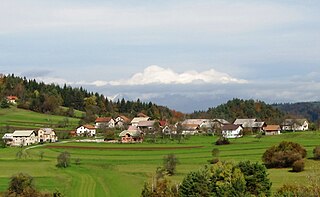
Avber is a village in the Municipality of Sežana in the Littoral region of Slovenia. The village includes the hamlets of Peganski Konec, Dolenski Konec, and Britof.

Leskovec pri Krškem is a settlement on the right bank of the Sava River in the Municipality of Krško in eastern Slovenia. The area was traditionally part of Lower Carniola. It is now included with the rest of the municipality in the Lower Sava Statistical Region. It includes the hamlets of Grad, Beli Breg, Veliki Marof, and Žadovinka. Older sources also mention the appertaining hamlet of Bajer.

Selo pri Robu is a settlement on the Rute Plateau in the hills southwest of Rob in the Municipality of Velike Lašče in central Slovenia. The municipality is part of the traditional region of Lower Carniola and is now included in the Central Slovenia Statistical Region.
Veliki Lipoglav is a small settlement in the hills southeast of Ljubljana in central Slovenia. It belongs to the City Municipality of Ljubljana and is part of the traditional region of Lower Carniola. It is now included with the rest of the municipality in the Central Slovenia Statistical Region.

Kal is a settlement in the Municipality of Hrastnik in central Slovenia. It lies in the hills north of Dol pri Hrastniku. Traditionally the area was part of the Styria region. It is now included with the rest of the municipality in the Central Sava Statistical Region. Kal includes the hamlets of Spodnji Kal and Veliki Kal.
Potok is a small settlement northwest of Šentlovrenc in the Municipality of Trebnje in the traditional region of Lower Carniola in Slovenia. The municipality is now included in the Southeast Slovenia Statistical Region.
Mačji Dol is a small settlement northwest of Šentlovrenc in the Municipality of Trebnje in eastern Slovenia. The municipality is part of the historical region of Lower Carniola and is now included in the Southeast Slovenia Statistical Region.
Gombišče is a small settlement in the Municipality of Trebnje in eastern Slovenia. The area is part of the historical region of Lower Carniola. The municipality is now included in the Southeast Slovenia Statistical Region. It includes the hamlet of Vrh.
Mirna Vas is a small village in the Municipality of Mokronog-Trebelno in southeastern Slovenia. The area is part of the historical region of Lower Carniola and is now included in the Southeast Slovenia Statistical Region. The village includes the hamlets of Mirna Dolina, Lipovec, and Vinjvršč.
Zavinek is a small settlement south of Škocjan in the traditional region of Lower Carniola in southeastern Slovenia. Within the Municipality of Škocjan, it belongs to the Local Community of Škocjan. The area is part of the Southeast Slovenia Statistical Region.

Mali Konec is a small settlement in the hills north of Polica in the Municipality of Grosuplje in central Slovenia. The area is part of the historical region of Lower Carniola. The municipality is now included in the Central Slovenia Statistical Region.
Mali Cirnik pri Šentjanžu is a village in the Municipality of Šentrupert in southeastern Slovenia. It lies in the hills east of Šentrupert just off the road towards Šentjanž in the historical region of Lower Carniola. The municipality is now included in the Southeast Slovenia Statistical Region. The settlement includes the hamlets of Stražberk, Vrhe, and Selo.
Straža is a settlement in the Municipality of Šentrupert in southeastern Slovenia. It lies on the road from Šentrupert towards Mirna in the historical region of Lower Carniola. The municipality is now included in the Southeast Slovenia Statistical Region. The settlement includes the hamlets of Kurja Dolina, Grilov Hrib, and Praproče.

Gabrje pri Stični is a settlement just north of Stična in the Municipality of Ivančna Gorica in central Slovenia. The area is part of the historical region of Lower Carniola. The municipality is now included in the Central Slovenia Statistical Region. The settlement includes the hamlets of Kurja Vas, Potok, Pungrt, and Nograd.
Cerovec is a dispersed settlement in the hills northeast of Šentjanž in the Municipality of Sevnica in central Slovenia. The area is part of the historical region of Styria. The municipality is now included in the Lower Sava Statistical Region. The settlement includes the hamlets of Podglina, Trebelno, Bajnof, Grič, Lesičjek, Veliki Vrh, Hom, and Pekel.
Veliki Cirnik is a village in the Municipality of Sevnica in east-central Slovenia. It lies southwest of Šentjanž in the historical region of Styria. The municipality is now included in the Lower Sava Statistical Region.
Gorenji Mačkovec is a remote abandoned former settlement in the Municipality of Kočevje in southern Slovenia. The area is part of the traditional region of Lower Carniola and is now included in the Southeast Slovenia Statistical Region. Its territory is now part of the village of Laze pri Oneku.
Veliki Koren is an uninhabited settlement in the Municipality of Krško in eastern Slovenia. The area was traditionally part of Lower Carniola. It is now included with the rest of the municipality in the Lower Sava Statistical Region.


