The Collegium Trilingue, often also called Collegium trium linguarum, or, after its creator Collegium Buslidianum, was founded in 1517 under the patronage of the humanist, Hieronymus van Busleyden.

Guldara is a village and the center of Guldara District, Kabul Province, Afghanistan. It is located at 34.8172°N 69.0878°E at 1722 m altitude, 45 km North of Kabul. The village was almost fully destroyed and now is continuing the process of rehabilitation. A new clinic has been opened. A local NGO, Afghan Educational and Rehabilitation Organisation (AERO) is running this clinic which will provide family planning, child and general health services to a population of around 38,000 people.

Arboleda is a town and municipality in the Nariño Department, Colombia. Its municipal seat is known as Berruecos.
Okopy is a village in the administrative district of Gmina Suchowola, within Sokółka County, Podlaskie Voivodeship, in north-eastern Poland.
16 Camelopardalis is a star in the constellation Camelopardalis. It has a dusty debris disk with a mean temperature of 120 K orbiting at a distance of 52 AU from the star. This disk has a combined mass equal to 2.1% the mass of the Earth.

Białotarsk is a village in the administrative district of Gmina Gostynin, within Gostynin County, Masovian Voivodeship, in east-central Poland. It lies approximately 11 kilometres (7 mi) west of Gostynin and 118 km (73 mi) west of Warsaw.
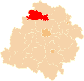
Stefanów is a village in the administrative district of Gmina Gostynin, within Gostynin County, Masovian Voivodeship, in east-central Poland. It lies approximately 7 kilometres (4 mi) north-east of Gostynin and 102 km (63 mi) west of Warsaw.
Strzałki is a village in the administrative district of Gmina Gostynin, within Gostynin County, Masovian Voivodeship, in east-central Poland. It lies approximately 3 kilometres (2 mi) west of Gostynin and 109 km (68 mi) west of Warsaw.
Sinogóra-Rozwozinek is a settlement in the administrative district of Gmina Lubowidz, within Żuromin County, Masovian Voivodeship, in east-central Poland.
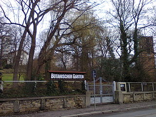
The Botanischer Garten Gera, also known as the Botanischer Garten der Museum für Naturkunde Gera, is a botanical garden located on the grounds of the Museum für Naturkunde der Stadt Gera at Nicolaistrasse 6, Gera, Thuringia, Germany. It is open daily without charge.
Jelašnica is a village in the municipality of Surdulica, Serbia. According to the 2002 census, the village has a population of 1173 people.
Eimuri is a village in Ādaži Municipality in the historical region of Vidzeme, and the Riga Planning Region in Latvia.
HD 120987 is a star system located in the constellation Centaurus. HD 120987 is a quintuple star system located 50 pc from the Sun. The system has an apparent magnitude of 5.565. Based on the system's parallax, it is located some 172 light-years away.
Marijan is a village in Behrestagh Rural District, in the Central District of Amol County, Mazandaran Province, Iran. At the 2006 census, its population was 28, in 7 families.
Fairview Township is a township in Jasper County, Iowa, USA.

The Church of Saint George, Sopotnica is a Serbian Orthodox church located at the village of Sopotnica in the Municipality of Novo Goražde in eastern Republika Srpska, Bosnia and Herzegovina. The church stands at the left bank of the Drina River, 4 kilometres from the town of Goražde. It was built in 1454 by Stefan Vukčić Kosača, when Goražde was part of a region ruled by him. The region would later come to be known as Herzegovina, after Kosača's title Herceg of Saint Sava. Herzegovina was gradually conquered by the Ottoman Empire between 1465 and 1481.
Folkeparken is the largest public park in central Roskilde, Denmark. The park adjoins two other parks, Berte Margrethe Anlægget and Klostermarken.

The Embassy of the United Kingdom in Tel Aviv is the chief diplomatic mission of the United Kingdom in Israel. The Embassy is located on Hayarkon Street in the Old North area of the city. The current British Ambassador to Israel is David Quarrey. The Embassy also represents the British Overseas Territories in Israel.
Hillcrest School is a secondary school for girls located in the Bartley Green area of Birmingham, in the West Midlands of England.

Moulay Yacoub is a spa town and municipality located 21 km northwest of Fez, Morocco. It is the capital of Moulay Yacoub Province and reported a population of 4612 in the 2014 Moroccan census. The baths use water pumped from 1500 m below ground and reach a temperature of 54 °C.