1929 New Zealand cyclone

Last updated

The cyclone of 1929 (also known as the Great Leith flood of 1929) was an unnamed tropical cyclone that struck New Zealand in mid-March 1929 causing widespread flooding and destruction.

Contents

Impact

The cyclone brought high winds to the northeast of the country, causing extensive damage in the Bay of Plenty on 18 March, before bringing heavy rain to coastal Canterbury and Otago, causing Dunedin's worst-ever flood. [1]

Bay of Plenty

Ōpōtiki township suffered one of its most severe gales, with roofs blown off marae buildings and local businesses. Maize crops were flattened, fruit trees were stripped, and many trees were blown over. [1]

Hawke's Bay

A foal was killed by a flying sheet of iron at Tirohanga. [1]

Canterbury

Heavy rain was recorded from Christchurch south, with 89 millimetres (3.5 in) falling in Waimate in 24 hours on 19–20 March. There was extensive flooding near the mouth of the Waihao River and around Duntroon. Crops were inundated in several parts of the region, and the South Island Main Trunk Railway was washed out south of Glenavy. [1]

Otago

There were floods throughout coastal Otago from Dunedin to Oamaru, and inland as far as Clyde. Heavy rainfall was recorded as far south as Balclutha. Burns Creek, inland from Waitati, recorded 224 millimetres (8.8 in) of rain in 24 hours on 19–20 March. Minor flooding occurred around the Kawarau Gorge and Cromwell, and several small creeks in the area became torrents, washing out roads, and severe damage was also caused to roads around Milton. Flooding occurred throughout both the residential and business precincts of Oamaru, and several retaining walls collapsed during the storm. Several houses were evacuated, and there was major damage to the Oamaru Public Gardens. [1]

Repairs being undertaken to Malvern Road at Glenleith in the Leith Valley after the 1929 flood. Leith remedial work above Rockside Bridge after flood 1929 (15281624322).jpg
Repairs being undertaken to Malvern Road at Glenleith in the Leith Valley after the 1929 flood.

Rail and other communication links were badly affected, with a railway worker killed as a result of the weather at Salisbury in the Taieri Gorge. [1]
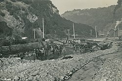
Dunedin

Heavy rain was recorded around Dunedin, with 139 millimetres (5.5 in) falling at Dunedin Botanical Gardens in 24 hours on 19–20 March. [1] The northern part of Dunedin was inundated by the heaviest flood in the city's history. Many houses were flooded from the city's Exchange area to North East Valley, [2] and many bridges were washed away. Significant damage was done by the undermining of walls, and roadways were washed away entirely in some places. Many business premises in the central city were inundated with water. The Water of Leith changed course, scouring out a new channel (part of which had been an earlier course of the river). [1]

In the southern part of the urban area, 100 houses were flooded from Cargill's Corner to Caversham, with the most badly affected area being around Kensington. The Kaikorai Stream became a torrent, flooding parts of Burnside and Green Island. Throughout the city a total of 506 houses were affected by floodwater. [3] Parts of Otago Peninsula were also isolated as slips blocked many of its roads. [1]

Deaths

At least one person lost his life as a result of the storm. The engine of a goods train from Ranfurly did not stop in time to avoid a washout in the Taieri Gorge. The train's fireman was drowned when the engine fell into the river. [4]

Aftermath

As a result of the storm, the lower reaches of the Water of Leith in Dunedin have now been contained within concrete channels, and the flow is controlled by several small weirs, notably just to the north of Woodhaugh Gardens and at the George Street bridge. [5] [6] The river's concrete channels close to its mouth were also doubled, creating a flood spillway channel. Further work to reduce the Leith's flooding risk was undertaken in the 1950s and 1960s and since the mid-1990s. There has been extensive flood protection work in progress since 2013, [7] [5] which is still ongoing, most recently resulting in the extensive closure of the Dundas St bridge. [8] [9]

Related Research Articles

<span class="mw-page-title-main">Otago</span> Region of New Zealand

Otago is a region of New Zealand located in the southern half of the South Island administered by the Otago Regional Council. It has an area of approximately 32,000 square kilometres (12,000 sq mi), making it the country's second largest local government region. Its population was 254,600 in June 2023.

<span class="mw-page-title-main">Clutha River</span> River in the South Island of New Zealand

The Clutha River is the second longest river in New Zealand and the longest in the South Island. It flows south-southeast 338 kilometres (210 mi) through Central and South Otago from Lake Wānaka in the Southern Alps to the Pacific Ocean, 75 kilometres (47 mi) south west of Dunedin. It is the highest volume river in New Zealand, and the swiftest, with a catchment of 21,000 square kilometres (8,100 sq mi), discharging a mean flow of 614 cubic metres per second (21,700 cu ft/s). The river is known for its scenery, gold-rush history, and swift turquoise waters. A river conservation group, the Clutha Mata-Au River Parkway Group, is working to establish a regional river parkway, with a trail, along the entire river corridor.

<span class="mw-page-title-main">Taieri River</span> River in New Zealand

The Taieri River is the fourth-longest river in New Zealand and is in Otago in the South Island. Rising in the Lammerlaw Range, it initially flows north, then east around the Rock and Pillar range before turning southeast, reaching the sea 30 kilometres (19 mi) south of Dunedin.

<span class="mw-page-title-main">Dunedin Railways</span>

Dunedin Railways is the trading name of Dunedin Railways Limited, an operator of a railway line and tourist trains based at Dunedin Railway Station in the South Island of New Zealand. The company is a council-controlled trading organisation wholly owned by Dunedin City Council through its holding company Dunedin City Holdings Limited.

<span class="mw-page-title-main">Strath Taieri</span> Geographic region in New Zealand

The Strath Taieri is a large glacial valley and river plateau in New Zealand's South Island. It is surrounded by the rugged hill ranges to the north and west of Otago Harbour. Since 1989 it has been part of the city of Dunedin. The small town of Middlemarch is located at its southern end.

<span class="mw-page-title-main">Water of Leith (New Zealand)</span> River in Dunedin, New Zealand

The Water of Leith, is a small river in the South Island of New Zealand.

<span class="mw-page-title-main">Tropical Storm Alberto (1994)</span> Atlantic tropical storm in 1994

Tropical Storm Alberto produced extensive and destructive flooding over portions of Alabama, Georgia, and Florida in July 1994. The first named storm of the annual hurricane season, Alberto developed from a tropical wave over the northwestern Caribbean Sea on June 30. Initially a tropical depression, the system moved westward, before curving northwestward on July 1 and entering the Gulf of Mexico. Early on the following day, the depression intensified into Tropical Storm Alberto. Alberto strengthened steadily over the Gulf of Mexico, and by midday on July 3, it peaked as a strong tropical storm with maximum sustained winds of 65 mph (100 km/h). A few hours later, the cyclone made landfall near Destin, Florida, at the same intensity. The system quickly weakened to a tropical depression early on July 4. Thereafter, a high pressure system caused Alberto to drift over west-central Georgia and central Alabama, until the storm dissipated over Alabama on July 7.

<span class="mw-page-title-main">1974 Brisbane flood</span> Deadly flood in 1974 in Brisbane, Queensland, Australia

In January 1974 a flood occurred in Brisbane, Queensland, Australia after three weeks of continual rain. The Brisbane River, which runs through the heart of the city, broke its banks and flooded the surrounding areas. The cyclone that produced the flood also flooded surrounding cities: Ipswich, Beenleigh, and the Gold Coast.

<span class="mw-page-title-main">1939 California tropical storm</span> Category 1 Pacific hurricane in 1939

The 1939 California tropical storm, also known as the 1939 Long Beach tropical storm, and El Cordonazo, was a tropical cyclone that affected Southern California in September 1939. Formerly classified a hurricane, it was the first tropical cyclone to directly affect California since the 1858 San Diego hurricane, and is the only tropical cyclone of tropical-storm strength to make landfall in the U.S. state of California. The storm caused heavy flooding, leaving many dead, mostly at sea.

<span class="mw-page-title-main">Otago Central Railway</span> Branch railway line in Otago, New Zealand

The Otago Central Railway (OCR) or in later years Otago Central Branch Railway, now often referred to as the Taieri Gorge Railway, was a secondary railway line in Central Otago, in the South Island of New Zealand.

<span class="mw-page-title-main">History of the Dunedin urban area</span>

The villages and then city that lay at the head of Otago Harbor never existed in isolation, but have always been a staging ground between inland Otago and the wider world. While Dunedin's current official city limits extend north to Waikouaiti, inland to Middlemarch and south to the Taieri River mouth, this articles focus is the history of the Dunedin urban area, only mentioning Mosgiel, the Otago Peninsula, Port Chalmers and inland Otago for context.

Floods in the United States before 1900 is a list of flood events that were of significant impact to the country, before 1900. Floods are generally caused by excessive rainfall, excessive snowmelt, and dam failure.

<span class="mw-page-title-main">Effects of Hurricane Dennis in Georgia</span>

The effects of Hurricane Dennis in Georgia included two deaths and $24 million (2005 USD) in damage. On June 29, 2005, a tropical wave emerged off the west coast of Africa. Gradually, the system organized on July 2 and formed a broad low pressure area. The system continued to organize, and it became a tropical depression on July 4. Tracking westward, it became a tropical storm on July 5 and a hurricane on July 7. Dennis rapidly intensified to attain Category 4 status on the Saffir-Simpson Hurricane Scale before making landfall on Cuba. The storm weakened to Category 1 status before re-emerging in the Gulf of Mexico and intensifying to a Category 4. Dennis weakened before the cyclone made landfall on the Florida Panhandle on July 10, then tracked over southeast Alabama.

<span class="mw-page-title-main">Climate of New Zealand</span>

The climate of New Zealand is varied due to the country's diverse landscape. Most regions of New Zealand belong to the temperate zone with a maritime climate characterised by four distinct seasons. Winters are relatively mild and summers comparatively cool. The main contributing factors are the Pacific Ocean and latitude, although the mountain ranges can cause significant climate variations in locations barely tens of kilometres from each other. Conditions vary from extremely wet on the West Coast of the South Island to almost semi-arid in Central Otago and subtropical in Northland.

<span class="mw-page-title-main">March 2010 Victoria storms</span> Series of storms in Victoria, Australia in 2010

The 2010 Victorian storms were a series of storms that passed through much of the Australian state of Victoria on 6 and 7 March 2010. One of the most severe storms passed directly over Greater Melbourne, bringing lightning, flash flooding, very large hail and strong winds to the state's capital.

<span class="mw-page-title-main">2011 Balochistan floods</span>

The 2011 Balochistan floods started from the last week of February and continued until the first week of March. Balochistan province was already badly affected from last year's devastating floods as UNHCR claims that 166,000 flood victims are still homeless in the province with 240 people still living in camps.

In June 1947 the southern half of Tasmania was affected by its largest floods on record. Although flooding at its peak between 16 and 18 June affected almost all rivers and streams across the island, in the rest of the state, the flooding did not approach the extent of the better-known 1929 floods. Floods on rivers such as the Derwent and Huon were the largest on record and caused considerable damage.

<span class="mw-page-title-main">Tropical Depression Eight (1981)</span> Atlantic tropical depression in 1981

Tropical Depression Eight caused severe flooding in southeastern Texas in late August 1981. The twelfth tropical cyclone of the annual hurricane season, the depression developed from a tropical disturbance over the Bay of Campeche on August 26. Moving northwestward, the cyclone failed to intensify into a tropical storm before making landfall in the Mexican state of Tamaulipas to the north of Tampico on August 28, with winds of 35 mph (55 km/h). After moving inland, the depression curved north-northwestward before degenerating into a surface low pressure area near the Mexico–United States border on August 29. The remnants moved eastward across Texas and entered Louisiana before dissipating on September 1.

On 3 June 2015, a low weather system brought heavy rain to the coastal Otago Region particularly South Dunedin. South Dunedin experienced heavy flooding, which was exacerbated by the area's high water table and the breakdown of the Portobello pumping station. 1,200 homes and businesses were damaged by flood damage. The Dunedin City Council (DCC) described the 3 June 2015 flood event as a "one in a 100 year" flood, with about 175mm of rain falling during a 24-hour period. The DCC subsequently drew criticism for the poor state of the city's storm water infrastructure.

References

  1. 1 2 3 4 5 6 7 8 9 "March 1929 Otago Flooding and Bay of Plenty High Winds (1929–03–18)," NIWA . Retrieved 10 December 2019.
  2. "Dunedin Lifelines: Chapter 3 – Hazards," civildefence.govt.nz, 1999. pp. 25–26. Retrieved 10 December 2019.
  3. "Flood damage," Otago Daily Times , 24 April 1929. Archived in paperspast.natlib.govt.nz. Retrieved 10 December 2019.
  4. ""Remarkable floods in Dunedin," The Advertiser (Adelaide), 21 March 1929. Archived at the National Library of Australia. Retrieved 10 December 2019.
  5. 1 2 "Leith Flood Protection Scheme". Otago Regional Council. Retrieved 10 December 2019.
  6. Herd, J., and Griffiths, G.J. (1980). Discovering Dunedin. Dunedin: John McIndoe.
  7. "Mitigating Leith floodwork aesthetics". 5 August 2013.
  8. "January start for last of Leith flood work". 29 November 2018.
  9. "Dundas St bridge to reopen to pedestrians". 10 October 2019.