
Salt Lake County is located in the U.S. state of Utah. As of the 2020 United States census, the population was 1,185,238, making it the most populous county in Utah. Its county seat and largest city is Salt Lake City, the state capital. The county was created in 1850. Salt Lake County is the 37th most populated county in the United States and is one of four counties in the Rocky Mountains to make it into the top 100. Salt Lake County has been the only county of the first class in Utah – under the Utah Code is a county with a population of 700,000 or greater. Although, Utah County directly to the south has recently reached this threshold.

The Wasatch Range or Wasatch Mountains is a mountain range in the western United States that runs about 160 miles (260 km) from the Utah-Idaho border south to central Utah. It is the western edge of the greater Rocky Mountains, and the eastern edge of the Great Basin region. The northern extension of the Wasatch Range, the Bear River Mountains, extends just into Idaho, constituting all of the Wasatch Range in that state.

The Wasatch Front is a major metropolitan region in the north-central part of the U.S. state of Utah. It consists of a chain of mostly contiguous cities and towns stretched along the Wasatch Range from approximately Santaquin in the south to Logan in the north, and containing the cities of Salt Lake City, Provo, Orem, Bountiful, Layton, and Ogden.

Snowbird is an unincorporated community in Little Cottonwood Canyon in the Wasatch Range of the Rocky Mountains near Salt Lake City, Utah, United States. It is most famous for Snowbird Ski and Summer Resort, an alpine skiing and snowboarding area, which opened in December 1971.

The Snowbelt, Snow Belt, Frostbelt, or Frost Belt is the region near the Great Lakes in North America where heavy snowfall in the form of lake-effect snow is particularly common. Snowbelts are typically found downwind of the lakes, principally off the eastern and southern shores.
A lake effect snow advisory was issued by the National Weather Service of the United States when lake effect snow may pose a hazard or is life-threatening. The snow must be completely caused by a convective snow development over a lake and not by a low pressure system. The criteria for this advisory vary from area to area.
The climate of Salt Lake City, Utah features cold and snowy winters, hot and dry summers, and modest to light seasonal rainfall. Lying in the Salt Lake Valley, the city is surrounded by mountains and the Great Salt Lake. Under the Köppen climate classification, Salt Lake City has either a Mediterranean climate (Csa) or dry-summer continental climate (Dsa) depending on which variant of the system is used, though it borders on a cold semi-arid climate (BSk) due to the city's relatively low precipitation.

The North American blizzard of 1996 was a severe nor'easter that paralyzed the United States East Coast with up to 4 feet (1.2 m) of wind-driven snow from January 6 to January 8, 1996. The City University of New York reported that the storm "dropped 20 inches of snow, had wind gusts of 50 mph and snow drifts up to 8 feet high." This storm was a classic example of a nor'easter, but the storm would not have been as historically significant without the presence of the arctic high pressure system located to the north of New York. It was followed by another storm, an Alberta Clipper, on January 12, then unusually warm weather and torrential rain which caused rapid melting and river flooding in the Northeast Floods later that month. Along with the March Superstorm of 1993 and the January 2016 United States blizzard, it is one of only three snowstorms to receive the top rating of 5, or "Extreme", on the Northeast Snowfall Impact Scale (NESIS).
The Early Winter 2006 North American storm complex was a severe winter storm that occurred on November 26, 2006, and continued into December 1. It affected much of North America in some form, producing various kinds of severe weather including a major ice storm, blizzard conditions, high winds, extreme cold, a serial derecho and some tornadoes.

The February 2007 North American blizzard was a massive winter storm that affected most of the eastern half of North America, starting on February 12, 2007 and peaking on Valentine's Day, February 14. The storm produced heavy snowfalls across the midwestern United States from Nebraska to Ohio and produced similar conditions across parts of the northeastern United States, and into Canada in Ontario, Quebec and New Brunswick. Significant sleet and freezing rain fell across the southern Ohio Valley and affected portions of the east coast of the United States, including the cities of Boston, Baltimore, Washington, D.C., New York City and Philadelphia.
The Great Salt Lake effect is a small but detectable influence on the local climate and weather around the Great Salt Lake in Utah, United States. In particular, snowstorms are a common occurrence over the region and have major socio-economic impacts due to their significant precipitation amounts. The Great Salt Lake almost never freezes and can warm rapidly, which allows lake enhanced precipitation to occur from September through May. Lake-enhanced snowstorms are often attributed to creating what is locally known as "The Greatest Snow on Earth".
The Early December 2007 North American winter storm was a major winter storm which affected the majority of the United States and portions of southern Canada from November 29 to December 5, hitting the Intermountain West and Midwestern United States, the Great Lakes region and the Northeast. The storm brought significant snows to portions of the Upper Midwest, Great Plains and Great Lakes regions of the United States and Canada on December 1 with a major winter storm for Quebec, Ontario and parts of the Northeast region on December 2 and 3 as well as the Canadian Maritimes on December 4 and 5. The system was also responsible for a major ice storm across the Midwestern states which caused disruptions to several major cities including Des Moines, Chicago, Detroit, Milwaukee and Toronto. The storm was blamed for at least 16 deaths across nine US states and one Canadian province. 10 traffic deaths had been reported, as of 2 December 2007.

The North American blizzard of 2008 was a winter storm that struck most of southern and eastern North America from March 6 to March 10, 2008. The storm was most notable for a major winter storm event from Arkansas to Quebec. It also produced severe weather across the east coast of the United States with heavy rain, damaging winds and tornadoes, causing locally significant damage. The hardest hit areas by the wintry weather were from the Ohio Valley to southern Quebec where up to a half a meter of snow fell locally including the major cities of Columbus, Ohio, Cleveland, Ohio, and Ottawa, Ontario. For many areas across portions of the central United States, Ontario and Quebec, it was the worst winter storm in the past several years. The blizzard and its aftermath caused at least 17 deaths across four US states and three Canadian provinces, while hundreds others were injured mostly in weather-related accidents and tornadoes.
The December 2008 North American snowstorms were a series of snowstorms that struck across Canada and the US. The snowstorms caused snow to fall across Canada and many parts of the United States, and broke records for the amount of snow accumulated in many cities on Christmas Day.

Global storm activity of 2008 profiles the major worldwide storms, including blizzards, ice storms, and other winter events, from January 1, 2008, to December 31, 2008. A winter storm is an event in which the dominant varieties of precipitation are forms that only occur at cold temperatures, such as snow or sleet, or a rainstorm where ground temperatures are cold enough to allow ice to form. It may be marked by strong wind, thunder and lightning, heavy precipitation, such as ice, or wind transporting some substance through the atmosphere. Major dust storms, Hurricanes, cyclones, tornados, gales, flooding and rainstorms are also caused by such phenomena to a lesser or greater existent.
Global weather activity of 2007 profiles the major worldwide weather events, including blizzards, ice storms, tornadoes, tropical cyclones, and other weather events, from January 1, 2007, to December 31, 2007. Winter storms are events in which the dominant varieties of precipitation are formed during cold temperatures; they include snow or sleet, or a rainstorm where ground temperatures are cold enough to allow ice, including freezing rain, to form. Thehy may be marked by strong wind, thunder, lightning thunderstorms, heavy precipitation, including ice storm, wind transporting some substance through the atmosphere, including dust storms, snowstorms, and hail storms. Other major non winter events such as large dust storms, hurricanes, cyclones, tornados, gales, flooding, and rainstorms are also caused by such phenomena.
Global weather activity of 2006 profiles the major worldwide weather events, including blizzards, ice storms, tropical cyclones, tornadoes, and other weather events, from January 1, 2006, to December 31, 2006. Winter storms are events in which the dominant varieties of precipitation are forms that only occur at cold temperatures, such as snow or sleet, or a rainstorm where ground temperatures are cold enough to allow ice to form. It may be marked by strong wind, thunder and lightning, heavy precipitation, such as ice, or wind transporting some substance through the atmosphere. Other major non winter events such as large dust storms, Hurricanes, cyclones, tornados, gales, flooding and rainstorms are also caused by such phenomena to a lesser or greater existent.

The 2011–12 North American winter by and large saw above normal average temperatures across North America, with the Contiguous United States encountering its fourth-warmest winter on record, along with an unusually low number of significant winter precipitation events. The primary outlier was Alaska, parts of which experienced their coldest January on record.
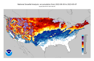
The 2022–23 North American winter was an unusually warm winter for the east and an unusually cold winter for the west in North America, as it occurred across the continent from late 2022 to early 2023. The winter season in North America began at the winter solstice, which occurred on December 21, 2022, and it ended at the March equinox, which occurred on March 20, 2023. The first day of meteorological winter began on December 1 and unofficially ended on February 28; winter storms may still occur outside of these limits.

In November 2022, a severe lake-effect winter storm impacted parts of Pennsylvania, Ohio, and New York, causing high accumulations of snow across the Great Lakes region, including snowfall accumulations upwards of 50 in (130 cm) in several locations. In Hamburg, New York, 81.2 in (206 cm) fell, while Orchard Park, New York recorded 80 in (200 cm) of snow. At least four fatalities occurred, with three in New York and one in Indiana, and several highways closed after heavy snowfall. A travel ban was also issued for New York by governor Kathy Hochul, and thundersnow occurred across areas impacted by the winter storm.
