Lantau Island is the largest island in Hong Kong, located west of Hong Kong Island and the Kowloon Peninsula, and is part of the New Territories. Administratively, most of Lantau Island is part of the Islands District of Hong Kong. A small northeastern portion of the island is located in the Tsuen Wan District.

Mui Wo is a rural town on the eastern coast of Lantau Island in Hong Kong. The 2011 Census recorded 5,485 people living in Mui Wo and its environs.

Tung Chung, meaning "eastern stream", is an area on the northwestern coast of Lantau Island, Hong Kong. One of the most recent new towns, it was formerly a rural fishing village beside Tung Chung Bay, and along the delta and lower courses of Tung Chung River and Ma Wan Chung in the north-western coast of Lantau Island. The area was once an important defence stronghold against pirates and foreign military during the Ming and the Qing dynasties.

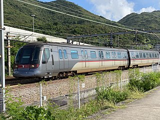
The Tung Chung line is one of the ten lines of the MTR system in Hong Kong, linking the town of Tung Chung with central Hong Kong. It was built in the 1990s as part of the Airport Railway project, part of the construction of the new Chek Lap Kok Airport. The line currently travels through eight stations in 31 minutes along its route. The line is coloured orange on the MTR system map.

Chek Lap Kok is an island in the western waters of Hong Kong's New Territories. Unlike the smaller Lam Chau, it was only partially leveled when it was assimilated via land reclamation into the 12.48 square kilometres (4.82 sq mi) island for the current Hong Kong International Airport, which opened for commercial aviation in 1998. The airport is popularly referred to as Chek Lap Kok Airport to distinguish it from the former Hong Kong International Airport, now commonly known as Kai Tak Airport.

The Airport Express is one of the ten rail lines of the Hong Kong MTR system. It links the urban area with Hong Kong International Airport and the AsiaWorld–Expo exhibition and convention centre.

Ngong Ping 360 is a bicable gondola lift on Lantau Island in Hong Kong. Intended to improve tourism to the area, the aerial lift was previously known as Tung Chung Cable Car Project before acquiring the Ngong Ping 360 brand in April 2005. It consists of the Ngong Ping Cable Car, formerly known as the Ngong Ping 360 Skyrail, and the Ngong Ping Village, a retail and entertainment centre adjacent to the cable car's upper station. Ngong Ping 360 connects Tung Chung, on the north coast of Lantau and itself linked to central Hong Kong by the Tung Chung line, with the Ngong Ping area in the hills above. This is home to the Po Lin Monastery and the Tian Tan Buddha, both already significant tourist attractions in their own right. Before Ngong Ping 360's opening, the only access was via a mountain road and bus service.

The Airport Core Programme was a series of infrastructure projects centred on the new Hong Kong International Airport during the early 1990s. The programme was part of the Port and Airport Development Strategy, commonly known as the Rose Garden Project.

North Lantau Highway is an expressway forming part of Hong Kong's Route 8, linking Hong Kong International Airport and Lantau Island with the rest of the territory. The road has three lanes in each direction for its entire length with full-width hard shoulders for emergencies and breakdowns. The speed limit is 110 kilometres per hour (68 mph) for most of its length, the highest of any road in Hong Kong.
A Site of Special Scientific Interest or SSSI is a special area to protect wildlife, habitats and geographic features based on scientific interest in Hong Kong. Scientific interests are special features relating to animal life, plant life, geology and/or geography. After being identified by the Agriculture, Fisheries and Conservation Department, these areas are documented by the Planning Department and added to maps. From 1975 to 2005, 67 locations were designated SSSIs throughout Hong Kong.

Typhoon Rose, known in the Philippines as Typhoon Uring, was the most violent and intense tropical cyclone to strike Hong Kong since Typhoon Wanda in 1962. The 21st named storm of the 1971 Pacific typhoon season, Rose developed from an area of disturbed weather while west of Guam on August 9. Moving west-northwestward, the storm briefly became a typhoon on the following day. After weakening to a tropical storm on August 11, Rose re-intensified into a typhoon several hours later. The system then curved westward and reached a primary peak intensity with winds of 205 km/h (127 mph) on August 13. Later that day, the typhoon made landfall near Palanan, Isabela in the Philippines. Rose weakened significantly while crossing the island of Luzon and was a minimal typhoon upon reaching the South China Sea on August 14.
The rainstorm warning signals are a set of signals used in Hong Kong to alert the public about the occurrence of heavy rain which is likely to bring about major disruptions such as traffic congestion and floods. They also ensure a state of readiness within the essential services to deal with emergencies.

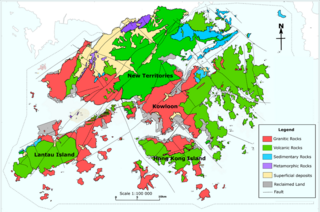
The geology of Hong Kong is dominated by igneous rocks formed during a major volcanic eruption period in the Mesozoic era. It made up 85% of Hong Kong's land surface and the remaining 15% are mostly sedimentary rocks located in the northeast New Territories. There are also a very small percentage of metamorphic rocks in the New Territories, formed by deformation of pre-existing sedimentary rocks (metamorphism).

The 2008 South China floods began on 26 May 2008. Four rounds of torrential rains with landslides and flooding lasted for 20 days and affected fifteen provinces in Eastern and Southern China.

Citygate is a commercial complex at the town centre of Tung Chung, Lantau Island, Hong Kong. It comprises a shopping centre called Citygate Outlets, an office tower, and the Novotel Citygate hotel.

This is a list of public housing estates on Lantau Island, Hong Kong.

Typhoon Vicente, known in the Philippines as Tropical Depression Ferdie, was the strongest tropical cyclone to strike the Chinese province of Guangdong since Hagupit in 2008, and was regarded as the strongest storm to affect Hong Kong and Macau in more than ten years. The eighth named storm and third typhoon of the 2012 Pacific typhoon season, Vicente began as a tropical depression on July 18, 2012 northeast of the Philippines. Vicente soon steadily moved into the South China Sea, and began to intensify above warm sea waters, and began explosive intensification early on July 23, and started to charge toward the Guangdong region prompting the Hong Kong Observatory (HKO) to issue the Hurricane Signal, No. 10, the first since York in 1999. The Macao Meteorological and Geophysical Bureau also hoisted Signal No. 9 for the first time since York and after the transfer of sovereignty over Macau. Late on the same day, Vicente made landfall over Taishan in Guangdong, China.
A series of major landslides occurred in Hong Kong in June 1972. Several apartment complexes and houses were wiped out, and at least 156 people lost their lives. The landslides had been caused by waterlogged soils in the area, a result of Typhoon Rose bringing unusually heavy rainfall in August 1971 as well as heavy rainstorms hitting Hong Kong on the days preceding the landslides.

In the evening of 7 September 2023, a heavy rainstorm struck the territory of Hong Kong and the Pearl River Delta area, including parts of Guangdong, China and Macau. The record rainfall caused widespread flooding and landslides in the cities, four dead and dozens injured.


