
The Kettle River Range, often called the Kettle Range, is the southernmost range of the Monashee Mountains, located in far southeastern British Columbia, Canada and Ferry County, Washington, in the United States. Most of the northern half of the range is protected by the Colville National Forest and the southern half of the range is located on the Colville Indian Reservation. The highest peak is Copper Butte, which reaches 2,177 metres (7,142 ft). The range is crossed by Washington State Route 20 at Sherman Pass.

The 2015 California wildfire season was a series of wildfires that burned across the state of California. By the end of 2015 a total of 8,745 fires were recorded, burning 893,362 acres (3,615 km2) across the state. Approximately 3,159 structures were damaged or destroyed by wildfires, and at least 7 fatalities were recorded.

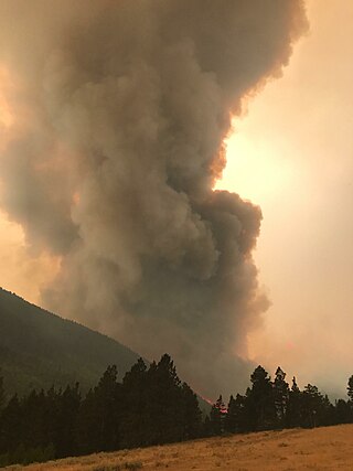
The Rice Ridge Fire was a wildfire that burned northeast of Seeley Lake in the Lolo National Forest in Montana in the United States. The fire, which was started by a lightning strike on July 24, 2017, became a megafire on September 3, growing from 40,000 acres (162 km2) to over 100,000 acres (405 km2), at which time it became the nation’s top wildfire priority as of early September 2017. Located north and east of Seeley Lake, Montana, over 700 firefighting personnel were assigned to the blaze, primarily active in a mountainous lodgepole and mixed conifer forest. The fire had burned 155,900 acres (631 km2) and at one point threatened over 1,000 homes in Powell County and Missoula County including the town of Seeley Lake, Montana and areas north of Highway 200, east of Highway 83. Evacuation orders included parts of Powell County north of Montana Highway 200, areas east of Montana Highway 83, and evacuation warnings for other sections of the forest within Missoula County.

The Lolo Peak Fire was a wildfire in Lolo National Forest and Bitterroot National Forest, Montana in the United States, that began by lightning strikes on the western flank of Lolo Peak, 10 miles southwest of Lolo, Montana on July 15, 2017. The fire burned a total of 53,902 acres (218 km2). One firefighter, Brent Witham, was killed working the fire, and another firefighter was injured. Two homes were destroyed, over 3,000 people were evacuated and 1,150 residences were threatened. The fire threatened homes along Highway 12 and Highway 93, impacting recreational activities in the area and the communities of Lolo and Florence.
The Alice Creek Fire was a wildfire north of Lincoln in the Lewis and Clark National Forest, located in Lewis and Clark County in Montana in the United States. The fire, started by a lightning strike, was reported on July 22, 2017. The fire burned at least 29,252 acres (118 km2). The Alice Creek Fire crossed the Continental Divide, impacting wildlife, specifically aquatic life, and threatened the Alice Creek Historic District.
The 2017 Montana wildfires were a series of wildfires that burned over the course of 2017.
The Park Creek Fire was a wildfire located two miles north of Lincoln in Helena National Forest and Lewis and Clark National Forest in Montana in the United States. The fire, which was reported on July 14, 2017, was started by lightning and burned over 18,000 acres (73 km2). It threatened the community of Lincoln and directly impacted recreational activities in the national forests.

The Weasel Fire was a wildfire 17 miles northeast of Eureka in the Kootenai National Forest in Montana in the United States. The fire was started by a lightning strike and first reported on September 2, 2017. The fire burned a total of 3,925 acres (16 km2) and was one of three fires, alongside the Gibralter Fire and Caribou Fire, burning in the vicinity at the same time.

The 2018 Washington wildfire season officially began June 1, 2018. A statewide state of emergency was declared by Governor Jay Inslee on July 31.

The 416 and Burro Fire Complex were two wildfires that burned in the southwestern portion of Colorado in the United States in 2018. The fires burned predominantly within San Juan National Forest, 13 miles north of Durango and 14 miles south of Rico. The 416 Fire started on June 1, 2018, and the Burro Fire followed on June 8. Federal officials allege that embers emitted from a coal-burning steam locomotive used by the historic Durango and Silverton Narrow Gauge Railroad started the blaze, and have filed a lawsuit against the railroad seeking recoupment of $25 million in firefighting costs, penalties and legal expenses. The fires burned a combined total of over 57,000 acres (23,067 ha) and have cost more than $43 million to contain. On March 31, 2022, the Durango and Silverton Narrow Gauge Railroad reached settlements in two lawsuits stemming from its role in starting the 416 fire: one settlement with federal authorities in which the railroad would pay $20 million to the federal government and institute a fire mitigation program for its operations. In the second settlement, the railroad agreed to pay an undisclosed amount to home and business owners impacted by the fire and subsequent floods during the summer monsoon season that followed in the wake of the 416 fire.

The Valley Fire was a wildfire that burned near the community of Forest Falls in San Bernardino National Forest, including the San Gorgonio Wilderness in California, United States. The fire was reported on July 6, one of a handful of brush fires that started in the area due to high temperatures and dry conditions. The Valley Fire burned 1,350 acres (5 km2) before it was fully contained on October 22. The fire impacted traffic on Highway 38 due to road closures and has caused evacuations of Forest Falls.

The Cranston Fire was a wildfire that burned in southwest Riverside County, California, in the United States. The fire was started on July 25, 2018, by Brandon M. McGlover, in an act of arson. The fire burned a total of 13,139 acres (53 km2), before it was fully contained on August 10. The Cranston Fire impacted the communities of Idyllwild and Mountain Center, as well as recreational activities in the Lake Hemet area, San Bernardino National Forest and Mount San Jacinto State Park. Over 7,000 people were evacuated due to the Cranston Fire.

The Long Hollow Fire was a wildfire burning five miles south of Dufur, Oregon in the United States. The fire was first reported on July 26, 2018 and has burned 78,425 acres (317 km2) .The fire was started by farm equipment. The fire is located just south of the Substation Fire. It is the third major fire of the 2018 Oregon wildfire season.
The Tucker Fire was a wildfire that burned near Clear Lake National Wildlife Refuge in Modoc County, California in the United States. The fire ignited on Sunday, July 28, 2019 along Highway 139 and went on to burn an estimated 14,217 acres of land. As of August 15, the fire was 95% contained. Officials say the wildfire was caused by traffic on Highway 139.

The Lake Fire was a wildfire that burned during the 2020 California wildfire season in the Angeles National Forest in Los Angeles County in the state of California in the United States. The fire, which was first reported on August 12, 2020, burned 31,089 acres (12,581 ha) near Lake Hughes. It was fully contained on September 28. The cause of the fire remains unknown. The fire has damaged 3 structures, destroyed 12 structures and 21 outbuildings, and injured 4 firefighters.

The 2020 Creek Fire was a very large wildfire in central California's Sierra National Forest, in Fresno and Madera counties. One of the most significant fires of California's record-setting 2020 wildfire season, it began on September 4, 2020, and burned 379,895 acres (153,738 ha) over several months until it was declared 100% contained on December 24, 2020. The Creek Fire is the fifth-largest wildfire in recorded California history and the second-largest single fire—i.e. not part of a larger wildfire complex—following the 2021 Dixie Fire.
The 2020 Lassen County wildfire season included seven large wildfires that burned entirely or in part in Lassen County. A total of 203,296 acres (82,271 ha) of land was burned in Lassen County, making it one of the larger clusters of fires in the 2020 California wildfire season.
The Tamarack Fire was a wildfire that burned 68,637 acres (27,776 ha), primarily in the Mokelumne Wilderness in Alpine County, California, Douglas County, Nevada and Lyon County, Nevada, as part of the 2021 California wildfire season.
